Best
17.5K views | +2 today
Follow
Best
Best or Top of a Category
Your new post is loading...
Scooped by Dr. Stefan Gruenwald
Scoop.it!

Data Visualization: 20+ Useful Tools and Resources for Interactive Maps

Data Visualization: 20+ Useful Tools and Resources for Interactive Maps | Best | Scoop.it

There are plenty of cool technologies available to collect and examine data. Both web and desktop applications have provided some really great interfaces to fall in love with data mining, and with the rise in popularity we have noticed an increased number of infographics created over the past few years.

No comment yet.
Rescooped by Dr. Stefan Gruenwald from OUR WEIRD WORLD
Scoop.it!

Analyzing Maps to Better Understand Global Current Events and History

Analyzing Maps to Better Understand Global Current Events and History | Best | Scoop.it

Maps tell stories about natural and human geography and geopolitics, whether by displaying the shapes of landforms and locations of cities or by highlighting global fashion trends or the routes of explorers.


But many students get overwhelmed by their own unfamiliarity with geography or by what might seem like an overload of information. Just like any other kind of visual thinking, learning to read maps accurately and with confidence takes practice. The authors of these lessons provide strategies to help students gain that confidence so they can interpret even the most complex historical or current maps. They also suggest ways for using current events maps as a tool to better understand both history and what’s going on in the world today.


Via Leonardo Wild
Kristen McDaniel's curator insight, January 22, 2016 10:57 AM

The NY Times learning blog really has some interesting, insightful lessons.  This one looks at using maps to understand culture and history, and how it affects today.  

Jamie Mitchell's curator insight, March 8, 2016 12:44 AM

Many of the more fortunate students (access to portable electronic devices, multi-car families with parents who drive them around, etc.) are actually worse off in map reading skills in part because they have never needed to develop a mental map and are not adept at navigating their neighborhoods (in the last few generations most and the range that part).  When these children become drivers, they are unable to navigate without GPS devices, but they still need to learn map reading skills. They are convinced that their apps can do all the work and that an old fashioned paper map is outdated technology, but their spatial thinking skills become atrophied. Spatial skills are crucial for understanding the world as a global citizen, to understand your local environs and for making scientific discoveries.  So teach a kid how to read a map...the sooner the better. 


Tagsmapping, K12, scale, location.

Nora Morton's curator insight, October 10, 2016 1:54 PM
A fantastic source on how to use maps in the classrooms and questions to help guide students into further exploration.  Provides numerous links to help understand the background and various types of maps, samples linking history with current events, and tools to create your own maps. 
Scooped by Dr. Stefan Gruenwald
Scoop.it!

13 JavaScript Libraries to Create Interactive & Customized Maps

13 JavaScript Libraries to Create Interactive & Customized Maps | Best | Scoop.it

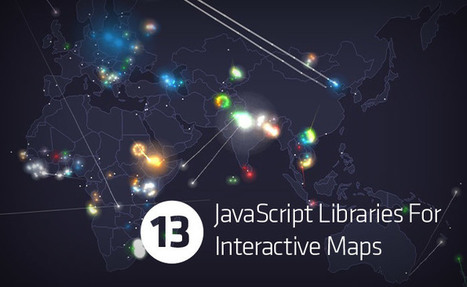
Hongkiat previously featured Google Map Maker and 10 other tools to help you build maps. However, if you prefer using Javascript libraries instead, have we got the post for you. Here are the JS libraries you can use to show special map markers, draw custom route lines or even show a dialog when you hover or click on certain points of the map. Personalize your maps in the style that you want — some of them can be styled with CSS — or customize your map to be as interactive as you like. The source of the map data, dependencies and licenses of each library has been included for your convenience.


More on Hongkiat:

No comment yet.
Rescooped by Dr. Stefan Gruenwald from Web Development | Resources | Inspirations
Scoop.it!

10 Easy to Use jQuery Google Maps Plugins and Tutorials

10 Easy to Use jQuery Google Maps Plugins and Tutorials | Best | Scoop.it
Google Maps is a very helpful tool and it's used by lots of people. It may be a bit difficult to integrate on your website but nowadays using jQuery plugins this has become a lot easier.

Via Levente Nagy
No comment yet.
Rescooped by Dr. Stefan Gruenwald from Eclectic Technology
Scoop.it!

40 Maps That Will Help You Make Sense of the World

40 Maps That Will Help You Make Sense of the World | Best | Scoop.it
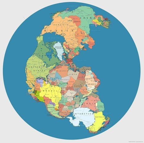
  If you're a visual learner like myself, then you know maps, charts and infographics can really help bring data and information to life. Maps can make a point resonate with readers and this c...

Via Beth Dichter
Olivier Aidyn's curator insight, August 16, 2013 12:44 AM

good work dude

Olivier Aidyn's comment, August 16, 2013 9:10 AM
Such a great infographics !
mtmeme's curator insight, August 16, 2013 10:31 AM

These are amazing!

Scooped by Dr. Stefan Gruenwald
Scoop.it!

12 Javascript Mapping Libraries

12 Javascript Mapping Libraries | Best | Scoop.it

JavaScript mapping libraries provide a way to display geodata. Sometimes they aggregate various mapping services behind a single interface.

No comment yet.
Scooped by Dr. Stefan Gruenwald
Scoop.it!

Top 7 Best Free Google Maps jQuery Plugins

Top 7 Best Free Google Maps jQuery Plugins | Best | Scoop.it
So in this article , we have compiled the top 7 of best free jQuery Google Maps Plugins that may offer a lot of map functionality in case you need them.
No comment yet.
Scooped by Dr. Stefan Gruenwald
Scoop.it!

7 Great Data Visualization + Business Intelligence Tools

7 Great Data Visualization + Business Intelligence Tools | Best | Scoop.it

In recent years, data and business intelligence in general has become an important part of business success. More and more business owners and teams are now relying on data more than ever before in order to make better decisions about customers, products, and systems. The problem is, data analysis doesn’t come very easy to most people. Unless you’re an experienced data scientist or a mathematician, it can be hard to interpret thousands of rows of data in a spreadsheet. Fortunately, there are a lot of great tools out there that can help make data analysis a lot easier.

No comment yet.
Scooped by Dr. Stefan Gruenwald
Scoop.it!

10 Free JavaScript Tools To Create Interactive Maps

10 Free JavaScript Tools To Create Interactive Maps | Best | Scoop.it
Here we are presenting a complete list of 10 JavaScript libraries to create interactive and customized maps. Though, there are Google Map maker and other tools to build maps but in this compilation, we are specifically presenting only JavaScript libraries that you can use to show special map markers.

We hope that this collection proves to be the best and will help you get going in the initial phases of your map designing project. It is once again our pleasure to share with you what we have gathered from all over the web so to help you with your masterpieces.
No comment yet.
Scooped by Dr. Stefan Gruenwald
Scoop.it!

22 maps and charts that will surprise you

22 maps and charts that will surprise you | Best | Scoop.it
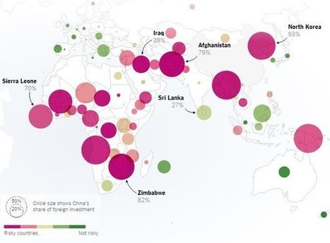
These 22 charts and maps all told me something I found surprising. Some of them genuinely changed the way I think about the world.
No comment yet.
Scooped by Dr. Stefan Gruenwald
Scoop.it!

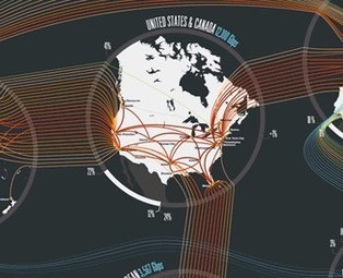
12 Maps That Map The Internet

12 Maps That Map The Internet | Best | Scoop.it

The internet is a worldwide network of computers, but it seems very intangible to most of us. In a general sense, the internet is made up of a lot of different components: Websites, users, servers, browsers, networking cables, and more. Some of these things have a physical component, and some of them do not, but even the ones that do have a physical component can be hard to conceptualize spatially. These maps help to lend that spatial component to the Internet.

No comment yet.
Scooped by Dr. Stefan Gruenwald
Scoop.it!

Google Maps: 100+ Best Tools and Mashups

Google Maps: 100+ Best Tools and Mashups | Best | Scoop.it
Most people think of Google Maps in terms of finding a place or business, or getting directions from one point to another. Others use the satellite images and terrain mapping fe...
No comment yet.
Scooped by Dr. Stefan Gruenwald
Scoop.it!

16 Best Free jQuery Map Plugins

16 Best Free jQuery Map Plugins | Best | Scoop.it

jQuery is one of the most popular javascript Libraries on the web, and almost every developer and designer are familiar with jquery’s functionality and features. jQuery resolves almost every issue and fits to your website requirements to make your website creative and innovative.


Nowadays most of the clients demand to integrate map plugin into their web applications. Most of the times, such plugins are only needed to integrate in to the contact page of a website, but these map plugins are useful for other functions as well that clients need such as gps tracker, navigation, etc.


To handle and resolve such situations, we are featuring 15 Best Free jQuery Google Maps Plugins, which are not only easy to implement into your websites but also offer a great deal of map functionality for site admins as well as for the end user interacting with them.

No comment yet.
Rescooped by Dr. Stefan Gruenwald from Illustrator ressources
Scoop.it!

100+ Free Vector Map Files

100+ Free Vector Map Files | Best | Scoop.it

I find myself constantly searching the web for awesome vector map .eps files to use in my projects.


Via Youyouk
No comment yet.