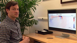
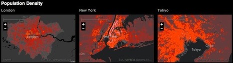
In this article, we will learn how to create a similar yet more customized plot using my favorite geovisualization package, Folium.I will also show you how to use the “Marker Cluster” feature of…...
Get Started for FREE
Sign up with Facebook Sign up with X
I don't have a Facebook or a X account


 Your new post is loading...
 Your new post is loading...
Your new post is loading...
In this article, we will learn how to create a similar yet more customized plot using my favorite geovisualization package, Folium.I will also show you how to use the “Marker Cluster” feature of…...
Phillip Trotter's insight:
This has been a really good series of articles on interactive GIS visualization - definitely worth reading

No comment yet.
Sign up to comment

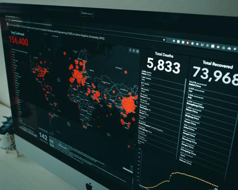
Digital volunteers are racing to map regions in West Africa where the Ebola virus, which has a 90 percent fatality rate, continues to spread
Phillip Trotter's insight:
The use of OpenStreetMap (OSM) as an unifying geodata system is increasing in humanitarian aid. The current Ebola outbreak in West Africa is a challenge at multiple levels for teams trying to coordinate a response. Due to years of war there are few up to date maps in the region and multiple boundaries mean different groups are collecting data. Digital volunteers creating new OSM entries will be a key asset in enabling health officials to manage the outbreak and hopefully bring things under control.

Overfishing and pollution are part of the problem, scientists say, warning that mass extinction of species may be inevitable
Phillip Trotter's insight:
Increasing acidification has been predicted by climate modellers and oceanographers for many many years. Hopefully we have not also passed the tipping point that they also described...

Each of the 24,000 dots on this map of London has been coloured according to its most frequently reported crime between May 2012 and April 2013. During this period, more than 250,000 crimes were reported – the equivalent of one every two minutes. Via James Cheshire
Phillip Trotter's insight:
great scoop by James Chesire - check out his scoop spot Spatial Analysis - awesome reading.
Phillip Trotter's insight:
ESRI's acquisition of CityEngine is probably one of the smartest tech acquisitions in the geospatial market in a long time. As the product and technology integration rolls forward we get to see how very smart the acquisition was.The WebGL publishing capabilities are very exciting for city planners. Great video of highlights from the recent ESRI user group conference its great seeing how the products are evolving.

Jed Fisher's curator insight,
July 19, 2013 4:50 PM
Nice job Dominik, Pascal, and Jack. Great to see how Proceedural has evolved with the acquistiion by ESRI (now 2-3 years ago). I'm glad ESRI has continued to take City Engine further. Love the swipe tool. Great urban planning tool.

NJVC will leverage the Cloudcuity AppDeployer application PaaS to integrate various apps to support the needs of a diverse population of international disaster first responders (e.g., law enforcement, fire response, disaster medical response) into a common complex humanitarian disaster (CHD) management operating environment.
Phillip Trotter's insight:
In this implementation, the AppDeployer PaaS extends and complements the Google Maps Engine development PaaS platform. Google will provide massively scalable, critical geospatial data and mapping services to the demonstration participants. The Cloud-based Google Maps Engine product lets users create, share, publish and view (via a browser or Google Earth client) purpose-built maps to address key CHD mission requirements. Clickon the title or image to learn more.
From
www

Stanford scientists have identified key acoustic characteristics of the 2011 Japan earthquake that indicated it would cause a large tsunami. The technique could be applied worldwide to create an early warning system for massive tsunamis.
Phillip Trotter's insight:
Computer simulations by Stanford scientists reveal that sound waves in the ocean produced by the earthquake probably reached land tens of minutes before the tsunami. If correctly interpreted, they could have offered a warning that a large tsunami was on the way. Click on the image or title to learn more.

Scientists link drilling-operation wastewater injection to a magnitude-5.7 earthquake that struck the US state of Oklahoma in 2011.
Phillip Trotter's insight:
Wastewater injection from drilling operations has been linked to seismic events in the past but a new study in Geology (http://bit.ly/YEpbIn) suggests that there are long term effects that have previously not been considered.
|
DirectionsMag.com
Phillip Trotter's insight:
IF you are involved in developing or using professional mapping, survey and photogrammetric products - Dielmo have released their back office cloud platform that enables teams to upload, store, process and share LiDAR, Raster, Vector data derived from UAV, Helicopter, Fixed-wing and Mobile platforms. Helping data acquisition companies to benefit from the latest in sensor and big data processing technologies, reducing the complexity of data processing and data analysis means Dielmo can help professional cartographers and cartographic solution developers - save time to market and operations costs.
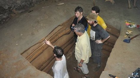
A cave on the northwestern coast of Sumatra holds a remarkable record of big tsunamis in the Indian Ocean. Scientists are using the site to help determine the frequency of catastrophes like the event of 26 December 2004.
Phillip Trotter's insight:
Sumatra's proximity to the Indo-Australia and Sunda tectonic plate boundary, and the giant earthquakes that occur there, means its shores are at risk of major inundations.Understanding how often these occur is important for policy and planning in the region. In the floor of the cave, encoded in the depositions of sand between layers of bat guano is a tsunami record providing detailed event histories from about 7,500 to 3,000 years ago that helps show the frequency of tsunamis in the region.
We investigate the growth dynamics of Greater London defined by the administrative boundary of the Greater London Authority, based on the evolution of its street network during the last two centuries. This is done by employing a unique dataset, consisting of the planar graph representation of nine time slices of Greater London's road network spanning 224 years, from 1786 to 2010. Within this time-frame, we address the concept of the metropolitan area or city in physical terms, in that urban evolution reveals observable transitions in the distribution of relevant geometrical properties. Given that London has a hard boundary enforced by its long standing green belt, we show that its street network dynamics can be described as a fractal space-filling phenomena up to a capacitated limit, whence its growth can be predicted with a striking level of accuracy. This observation is confirmed by the analytical calculation of key topological properties of the planar graph, such as the topological growth of the network and its average connectivity. This study thus represents an example of a strong violation of Gibrat's law. In particular, we are able to show analytically how London evolves from a more loop-like structure, typical of planned cities, toward a more tree-like structure, typical of self-organized cities. These observations are relevant to the discourse on sustainable urban planning with respect to the control of urban sprawl in many large cities which have developed under the conditions of spatial constraints imposed by green belts and hard urban boundaries.
Masucci AP, Stanilov K, Batty M (2013) Limited Urban Growth: London's Street Network Dynamics since the 18th Century. PLoS ONE 8(8): e69469. http://dx.doi.org/10.1371/journal.pone.0069469 Via Complexity Digest
Phillip Trotter's insight:
Mike Batty has created a truly world class research group and this paper by Paula Masucci and Mike is a great addition to literature relating to sustainable cities.
Phillip Trotter's insight:
Arsttechnica article describing research published in Geology where researchers used publicly available data from 33 deep wells drilled by the oil and gas industry in the Gulf of Mexico combined with seismic images of the region to identify massive Seafloor 'landslides' which occured as the result of the Chicxulub impact. The asteroid impact which ended the reign of the dinasaurs shook loose sediment along well over 2,000 miles of submarine slopes along the east coast of the United States as well as the Gulf of Mexico. Link to the orginal Geology paper at the end of the article.
From
gigaom
A new online mapping tool wants to make better urban planning by comparing a standardized map experience.
Phillip Trotter's insight:
Launched at ESRI's user conference the urban observatory enables cities to upload data and compare structural organisation, traffic, landuse, housing density, open space distribution and other variables. The gigaom article explains the aims and includes a video of Jack Dangermond and Richard Saul Wurman who jointly launched the venture.

2013 Esri International User Conference in San Diego, California, from July 8-12, 2013. Esri's yearly user conference is the largest geospatial conference.
Phillip Trotter's insight:
ESRI maybe the grandfather company of the GIS industry- but they constantly innovate and their user base does incredible things with their GIS technologies. The annual ESRI user conference is a great source of info and the videos from the key notes are worth watching. If you can take time to watch the STEM & GIS in schools with the incredibly impressive student team from Roosevelt High School and then watch the Will.iam and Jack Dangermond interview. .

According to a report by the Boston Consulting Group (BCG) the geospatial services industry in the United States generates annual revenues of $75 billion annually. That is about 0.5 % of the US GDP. The report breaks the geospatial services...
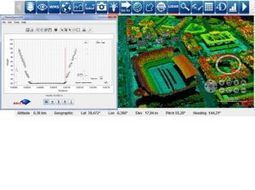
I'm a bog fan of Geoff Zeiss's blog Between the Poles - H ehas a great review of the Eclipse Foundation Locationtech teleconference presentation by Matt Ford of Cesium Cesium is an open source 3D, 2.5 D and 2D globe visualisation toolkit written in webgl. Planned support for Openlayers is ont he roadmap which will make it a very interesting customizable alternative to Google Earth or WorldWind for specific applications. Click on the image or title to learn more.
|