


DirectionsMag.com
DIELMO 3D Provides Geospatial Back-Office for UAV, Heli, Fixed-Wing and ...
Get Started for FREE
Sign up with Facebook Sign up with X
I don't have a Facebook or a X account


 Your new post is loading...
 Your new post is loading...
Your new post is loading...
DirectionsMag.com 
No comment yet.
Sign up to comment
|
With the combining increasingly of the Geographic Information System (GIS), Remote Sensing (RS) technologies with the modern network communication technology, some unique advantages have been displaying in the monitoring, forewarning and disaster... Via Knapco

Knapco's curator insight,
December 28, 2012 11:31 PM
RS and GIS technologies were used in processing of professional meteorological data like MODIS remote sensing images, the doppler radar echoes and the Meteoroloical Information Collecting, Analyzing and Processing System (MICAPS). The system is based on WebGIS and is convenient for the use of the agro-meteorological professionals, who use biological data and monitor weather diseaster events like spring frost, heal and drought. For some model crops some object-oriented user interfaces were developed with functions of the database management, data querying, map displaying, graphics rendering, spatial analysis, the professional data processing, information extraction, figure and table output. Read more.... |


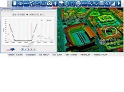
IF you are involved in developing or using professional mapping, survey and photogrammetric products - Dielmo have released their back office cloud platform that enables teams to upload, store, process and share LiDAR, Raster, Vector data derived from UAV, Helicopter, Fixed-wing and Mobile platforms. Helping data acquisition companies to benefit from the latest in sensor and big data processing technologies, reducing the complexity of data processing and data analysis means Dielmo can help professional cartographers and cartographic solution developers - save time to market and operations costs.