Human Interest
198.8K views | +0 today
Follow
Human Interest
Your new post is loading...
Rescooped by Skuuppilehdet from AP HUMAN GEOGRAPHY DIGITAL STUDY: MIKE BUSARELLO
Scoop.it!

Vultures, Environment, and Mapping Trash

"For generations we vultures, armed with our senses, have fought in silence. We’ve waged a battle against garbage, but now we’re losing that battle. We want to help humans, so we’ve launched a movement to help you detect piles of garbage so that you can take action to eliminate them. Join us in this fight. Vultures Warn, you take action!"


Via Mike Busarello's Digital Storybooks
Kelvis Hernandez's curator insight, September 29, 2018 11:00 PM
An ingenious idea to clean up the environment. This group is based out of Lima, Peru uses the vultures in the city to find the piles of garbage and refuse left by people and set up events to clean up the area. It is an amazing way to utilize nature to help us solve the problems we caused ourselves. They utilize the vultures by putting GPS devices and GoPro cameras on them and wait until they locate large trash piles. The video itself is so well-made and interesting that it almost forces you to learn more by checking out their website and their social media pages. The phrase they use is "Gallinazo Avisa, Tu Actuas" translates to vultures warn, you act. 
1
Rescooped by Skuuppilehdet from AP HumanGeo
Scoop.it!

Five reasons why we should still read maps

Five reasons why we should still read maps | Human Interest | Scoop.it
The Royal Institute of Navigation says reliance on sat-navs is undermining map-reading skills. So why should we still read maps?

Via Dawn Haas Tache
bernieshoot's curator insight, June 5, 2015 6:56 AM

#geography #education 

Catherine Lamarque's curator insight, June 6, 2015 5:55 AM
Lire un carte est toujours le début d'une histoire...
Adilson Camacho's curator insight, June 6, 2015 12:44 PM

É isso aí!

Rescooped by Skuuppilehdet from AP HumanGeo
Scoop.it!

In Kenya, Using Tech To Put An 'Invisible' Slum On The Map

In Kenya, Using Tech To Put An 'Invisible' Slum On The Map | Human Interest | Scoop.it
A billion people worldwide live in slums, largely invisible to city services and governments — but not to satellites.

Via Dawn Haas Tache
John Blunnie's curator insight, July 28, 2013 1:11 PM

Great how tech and globalization can help represed people in other countries.

Meagan Harpin's curator insight, October 6, 2013 5:07 PM

The slum-mapping movement began in India almost a decade ago and migrated to africa, the idea of this is to make slums a reality to people who have never set foot in one before. The maps can be used in court to stop evictions or simply to raise awarance. I think this idea is on the right track of what needs to be done. These people need help and so many people incuding the governement pretend they arent their but with these maps as proof they can no longer do that.    

Elizabeth Bitgood's curator insight, March 19, 2014 10:24 AM

Slums and squatter settlements are a problem that a lot of the developing world has to deal with.  The unsafe and unsanitary buildings cause headaches and problems for the leaders of the cities they surround.  This story is hopeful in that the city did manage to bring a water line out to get clean water to the people living in this area.  Perhaps this will lead to a better quality of life of the inhabitants of this particular slum.  Also the project of mapping such areas can be a useful tool for city planners to better regulate these areas and help the people that live there.,

Scooped by Skuuppilehdet
Scoop.it!

Giant Concrete Arrows Across America

Giant Concrete Arrows Across America | Human Interest | Scoop.it
Every so often, a hiker or a backpacker will run across something puzzling: a ginormous concrete arrow, as much as seventy feet in length, just sitting in the middle of scrub-covered America. What are these giant arrows? Jeopardy champ Ken Jennings solves the mystery.
Rescooped by Skuuppilehdet from AP HUMAN GEOGRAPHY DIGITAL STUDY: MIKE BUSARELLO
Scoop.it!

Latitude and Longitude of a Point

Latitude and Longitude of a Point | Human Interest | Scoop.it
Find the latitude and longitude of a point using Google Maps.


Simple, straightforward and easy to use.  All you do is point and click on the map to get latitude and longitude in both decimal degrees and DMS (degrees, minutes and seconds).  You can also quickly enter coordinates in either format an have the location displayed on the map.


Tags: GPS, mapping, location.


Via Seth Dixon, Mr. David Burton, Mike Busarello's Digital Storybooks
No comment yet.
Scooped by Skuuppilehdet
Scoop.it!

Paper maps still relevant even with computers, GPS

Paper maps still relevant even with computers, GPS | Human Interest | Scoop.it

"The president and owner of Mapping Specialists, David Knipfer, said maps are more prevalent in society now than they’ve ever been, from turn-by-turn direction apps, to restaurant searches, to social networks that pinpoint users’ locations. Maps aren’t going away, but people are learning to use them in a different way, Knipfer said."

Rescooped by Skuuppilehdet from AP HUMAN GEOGRAPHY DIGITAL STUDY: MIKE BUSARELLO
Scoop.it!

The Precision Agriculture Revolution

The Precision Agriculture Revolution | Human Interest | Scoop.it

"Thousands of years ago, agriculture began as a highly site-specific activity. The first farmers were gardeners who nurtured individual plants, and they sought out the microclimates and patches of soil that favored those plants. But as farmers acquired scientific knowledge and mechanical expertise, they enlarged their plots, using standardized approaches—plowing the soil, spreading animal manure as fertilizer, rotating the crops from year to year—to boost crop yields. Over the years, they developed better methods of preparing the soil and protecting plants from insects and, eventually, machines to reduce the labor required. Starting in the nineteenth century, scientists invented chemical pesticides and used newly discovered genetic principles to select for more productive plants. Even though these methods maximized overall productivity, they led some areas within fields to underperform. Nonetheless, yields rose to once-unimaginable levels: for some crops, they increased tenfold from the nineteenth century to the present.  

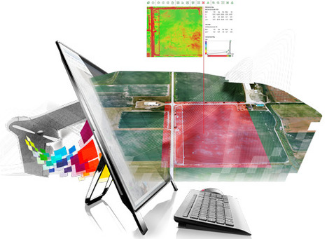
Today, however, the trend toward ever more uniform practices is starting to reverse, thanks to what is known as 'precision agriculture.' Taking advantage of information technology, farmers can now collect precise data about their fields and use that knowledge to customize how they cultivate each square foot."


Tags: technology, food production, agriculture, agribusiness, spatial, GPS.


Via Mike Busarello's Digital Storybooks
Cade Johns's curator insight, December 2, 2015 9:57 AM

Agriculture has evolved very much over time to many different methods of growing things and theyve changed the way we affect the soil.-CJ

Samuel bennett's curator insight, January 10, 2017 11:50 AM

In this article it talks about the development of agriculture  and how most of it started. This article relates to my world cultural geography class by telling how people used agriculture to provide for themselves and better there methods year after year. The use of technology and the pesticides they used to help there crops grow is similar  in our class to the was technology was developed and helped out a lot in the fields and in everyday life.

Alanna Thompson's curator insight, January 10, 2017 1:17 PM

This is very interesting insight on how farmers use precision agriculture to customize how they cultivate each square foot of their fields. In my opinion precision agriculture is a good way for farmers to know exactly what they need to do to their field and what they should plant. It also is a way for them to make sure none of the areas within their field underperform. 

Scooped by Skuuppilehdet
Scoop.it!

Now, Anyone On Earth Can See A View Of Our Planet From Space In Real Time - Business Insider

Now, Anyone On Earth Can See A View Of Our Planet From Space In Real Time - Business Insider | Human Interest | Scoop.it
NASANorth Korea (the dark area) and South Korea at night.There's nothing as profound as seeing Earth from space. Yet, only the 543 people who have trained...
No comment yet.
Rescooped by Skuuppilehdet from Mr Hill's Geography
Scoop.it!

Spatial Navigation Before GPS

Spatial Navigation Before GPS | Human Interest | Scoop.it

"Giant 70-foot concrete arrows that point your way across the country, left behind by a forgotten age of US mail delivery.  Long before the days of radio (and those convenient little smartphone applications), the US Postal service began a cross-country air mail service using army war surplus planes from World War I.  The federal government funded enormous concrete arrows to be built every 10 miles or so along established airmail routes they were each built alongside a 50 foot tall tower with a rotating gas-powered light. These airway beacons are said to have been visible from a distance of 10 miles high."


Via mrhill
Giovanni Sonego's curator insight, December 15, 2013 1:49 PM

Adesso sembra incredibile che si usasse un sistema simile per guidare la posta aerea. Forse a quei tempi sembrava normale. 

Steven Flis's curator insight, December 16, 2013 3:14 AM

I love articles like this one where they talk about the collide of different times. This article speaks of huge concrete arrows which were left from 1930's air mail routes. sadly most of the towers that were paired with the arrows have been dismantled but still really cool that these directional arrows from the past can still be found almost 90 years later.

Elle Reagan's curator insight, September 28, 2014 11:44 PM

Wow technology has come a long way in just a short amount of time! We would still be using  those stone arrows if it wasn't for the invention of the GPS.