Human Interest
198.8K views | +0 today
Human Interest
Your new post is loading...
Rescooped by Skuuppilehdet from HMHS History
Scoop.it!

The danger of a single story

The danger of a single story | Human Interest | Scoop.it
Our lives, our cultures, are composed of many overlapping stories. Novelist Chimamanda Adichie tells the story of how she found her authentic cultural voice -- and warns that if we hear only a single story about another person or country, we risk a critical misunderstanding.

Via Michael Miller
No comment yet.
Rescooped by Skuuppilehdet from AP HUMAN GEOGRAPHY DIGITAL STUDY: MIKE BUSARELLO
Scoop.it!

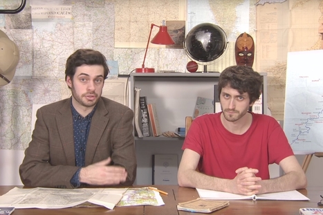
Map Men: teaching geography through comedy

Map Men: teaching geography through comedy | Human Interest | Scoop.it
Mark Cooper-Jones and Jay Foreman, the Map Men, tap into a rich vein of geographical quirks to teach through comedy

Via Mike Busarello's Digital Storybooks
Jeremy Hansen's curator insight, August 29, 2016 12:43 PM
Holy heck these guys are good! I'd like to see more of these Map Men videos. I'm sure at least some of my 8th graders can appreciate some British wit.
Colleen Blankenship's curator insight, January 22, 2018 1:21 PM
Funny and full of information!
Laurie Ruggiero's curator insight, May 29, 2018 5:29 PM
Unit 1
Scooped by Skuuppilehdet
Scoop.it!

The dirty little secret that data journalists aren’t telling you

The dirty little secret that data journalists aren’t telling you | Human Interest | Scoop.it
How to tell two radically different stories with the same dataset.
Jose Sepulveda's curator insight, July 29, 2016 1:19 PM
thee precaution should be taken with environmental data published as integrated variable maps   
Colleen Blankenship's curator insight, August 4, 2016 9:12 AM
Maps, like statistics, can tell very different stories using the same information!  Read this for some examples!
Mr Mac's curator insight, August 16, 2017 7:17 PM
Unit 1 - Thematic Maps (use of )
Scooped by Skuuppilehdet
Scoop.it!

Pisa tests to include 'global skills' and cultural awareness

Pisa tests to include 'global skills' and cultural awareness | Human Interest | Scoop.it

"Pisa tests, an international standard for comparing education systems around the world, could include a new measurement of global skills in the next round of tests in 2018. The OECD, which runs the tests in maths, reading and science, is considering adding another test which would look at how well pupils can navigate an increasingly diverse world, with an awareness of different cultures and beliefs. The OECD's education director Andreas Schleicher explains why there is such a need for new rankings to show young people's competence in a world where globalisation is a powerful economic, political and cultural force.

Education leaders around the world are increasingly talking about the need to teach 'global competences' as a way of addressing the challenges of globalisation."

Euneos's curator insight, June 2, 2016 1:23 AM
Kansainvälistyminen nousee uudeksi mitattavaksi asiaksi PISA-tutkimuksissa 2018. Miten mahtaa suomalaisten peruskoulujen käydä? Pystyvätkö ne globaalitaidoissa ja kulttuurienvälisessa osaamisessa yltämään samalle tasolle kuin kansainvälistymisessä pitkälle edistyneet Britannia, Hollanti, Belgia tai Tanska. Oma kokemukseni jo 10 vuotta jatkuneesta Intia-yhteistyöstä (http://www.eumind.net) ei ennakoi Suomen kouluille huipputuloksia. Mutta toivotaan parasta.
Jaume Busquets's curator insight, June 4, 2016 7:41 AM
Share your insight
Scooped by Skuuppilehdet
Scoop.it!

Eratosthenes calculation for the size of the earth around 240 BC

No comment yet.
Rescooped by Skuuppilehdet from Geography for All!
Scoop.it!

Changes in Three Gorges Dam

NASA's animation of China's Three Gorges Dam construction over the years.

Via Trisha Klancar
Benjamin Jackson's curator insight, November 9, 2015 5:40 PM

The impact of the Three Gorges Dam on the residents upstream is amazing. I cannot imagine anything like this happening in the US, mostly because of the impact on the people both upstream and downstream. Ecological damage from this dam may not phase the Chinese government, but I think any North American or European government would shudder at the thought of the backlash among their citizens this would create.

Matt Ramsdell's curator insight, December 14, 2015 9:27 PM

Three Gorges damn in China is the largest dam ever constructed. This was created to save on power by creating hydroelectric power for the people of the land. One of the issues with this was the the flooding of the land up streams displacing millions of people. It created a larger up stream area and very small down stream. A lot of the people that lived up stream had to be relocated further inland and faced changing climatif weather. The banks of the river are carved out between what seems like mountainous regions so as you move more uphill the weather and temperature will be a whole new category of life (Depending on how far you relocated).

Stevie-Rae Wood's curator insight, December 9, 2018 6:09 PM
From the animation that NASA has created of the construction of the Three Gorges Dam it is apparent that land has been lost. The Three Gorges Dam was created to generate more energy for Chinas growing economy. It is known as the largest hydroelectric project ever costing around 40 billion dollars and requiring 20,000 workers. There is a good and bad side to the creation of this dam. It has helped Chinas economy grow however to the expense of the people that were displaced because the dam took away land as we can see In the animation. It also effected people downstream negatively as we can see as well because there water supply was depleted. Like most things that take place today the people that benefit from something usually live far away from the problem while those that live closest pay the more costly price.
Scooped by Skuuppilehdet
Scoop.it!

Human activities are reshaping Earth's surface

Human activities are reshaping Earth's surface | Human Interest | Scoop.it

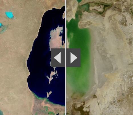
"By moving the slider, the user can compare 1990 false-color Landsat views (left) with recent true-color imagery (right). Humans are increasingly transforming Earth’s surface—through direct activities such as farming, mining, and building, and indirectly by altering its climate."

James Piccolino's curator insight, March 24, 2018 9:46 AM
Wow. This is depressing. I knew of the Aral sea thanks to class, but the others I had no idea. They were so green and lush way back in the day. Now they are dead and seriously in a sad state. There is nothing wrong with development and advancement, but this is just a lot when it comes to impact.
othni lindor's curator insight, October 20, 2018 4:01 AM
This map shows how human activities like farming has shaped the Earth's surface. The example they show is the Aral Sea. It is a 
regional environmental problem. It is located between the Southern part of Kazakhstan and Northern Uzbekistan. It used to be the world's fourth largest saline lake. Human activities have caused the lake to be almost completely dried up. Over the years, the Aral Sea became polluted with pesticides and chemicals. 


Stevie-Rae Wood's curator insight, October 28, 2018 9:51 PM
The Aral Sea is a severe environmental issue in Central Asia. This map that we are looking at shows how human activities such as farming have destroyed a natural wonder. The Aral Sea USED to be the fourth largest saline lake but has dried up. The Aral Sea has five times less volume and is five times more saltier than it once was. This occurred because people surrounding the area used more water and used it more intensely. The soviets thought it would be a good idea to use more water projects such as planting cotton, and rice which are water intense crops. This severely dried up the Sea. The area that the sea once was that is now dry land in uninhabitable because of the levels of salt left behind. As well the rivers that connected to the Aral Sea have either dried out or are on the verge of drying out causing many economic problems for those that depended on that water.
Scooped by Skuuppilehdet
Scoop.it!

The Drying of Lake Urmia

The Drying of Lake Urmia | Human Interest | Scoop.it

"Lake Urmia in northwestern Iran was once one of the largest saltwater lakes in the Middle East, but it has diminished dramatically. Diversion of water from local rivers for agricultural use is one likely cause. Since 1996, drought has further contributed to the decline. The lake now covers about 10 percent of the area it covered in the 1970s. In the 2014 image, the entire southern portion of the salty lakebed is exposed. Also see this set of images."


Tags: Iran, remote sensing, geospatial, unit 1 Geoprinciplesland use, foodfood production, environment.

No comment yet.
Scooped by Skuuppilehdet
Scoop.it!

What is Geography?

Flo Cuadra Scrofft's curator insight, March 21, 2015 9:38 PM

This presentation talks about the misconceptions of geography and about what it really involves. Geographers describe and try to explain how locations interact and relate to one another; are arranged the way they are; and have become what they are now. They also use critical thinking to project what the world might look like in the future. As there's usually so many questions that have to be answered, geography is an interdisciplinary work, meaning that it is a blend of natural sciences, social sciences, and humanities. Geographers also develop other skills, such as mapping and graphing (spatial representation skills) and development of verbal concepts, frameworks and mathematical models (spatial theorizing skills). Geography, therefore, can be used to study many issues, such as climate change, sustainability, human rights, among others.

Reflection- as the presentation accurately shows, many people believe that geography is just about memorizing countries and our world's natural resources locations, but in reality, geography goes much deeper than that. Geography is about asking questions and trying to come out with the best answers in order to solve issues that can range from local usage of land to international security.

Gregory Stewart's curator insight, August 29, 2015 9:37 AM

Prezi created by students interested in the field of geography.

Alex Smiga's curator insight, September 7, 2015 4:26 PM
Seth Dixon's insight:

This Prezi was created by students from theSyracuse Geography Department as part of a Senior Seminar to explain the disciple, the major and its utility.   This is a great recap of the discipline, the major and it's utility.

Rescooped by Skuuppilehdet from AP HUMAN GEOGRAPHY DIGITAL STUDY: MIKE BUSARELLO
Scoop.it!

A Landsat Flyby

"The Landsat program is the longest continuous global record of the Earth's surface, and continues to deliver both visually stunning and scientifically valuable images of our planet. This short video (download here) highlights Landsat's many benefits to society."


Tags: remote sensing, geospatial, unit 1 GeoPrinciples.


Via Mike Busarello's Digital Storybooks
Stephen Zimmett's curator insight, October 13, 2014 1:00 PM

another great bit of info from Seth

GTANSW & ACT's curator insight, October 19, 2014 7:34 PM

Environmental change at a variety of scales 

Scooped by Skuuppilehdet
Scoop.it!

What Does Earth Look Like?

Courtney Barrowman's curator insight, August 27, 2014 12:37 PM

Unit 1

MsPerry's curator insight, September 1, 2014 9:51 AM

APHG-Unit 1

Alex Smiga's curator insight, September 7, 2015 4:29 PM
Seth Dixon's insight:

This video covers various topics important to mapping and satellite imagery (and alesson from an APHG teacher on how to use this video with other resources).  There is so much more to the world and space than what we can see see.  Chromoscope, referenced in the video, simulates other forms of energy on the electromagnetic spectrum besides just visible light.  This type of information is at the core of the science behind all of our satellite imagery.  This video also covers many map projection issues and highlights online resources to understand map distortion including:

Google’s Mercator Map PuzzleJason Davies’ interactive map projection websiteInteractive Gnomonic Projectionand the military's live rendering of what the Earth looks like right now.  
Rescooped by Skuuppilehdet from AP HUMAN GEOGRAPHY DIGITAL STUDY: MIKE BUSARELLO
Scoop.it!

Most Young Americans Can’t Pass a Test on Global Affairs—Can You?

Most Young Americans Can’t Pass a Test on Global Affairs—Can You? | Human Interest | Scoop.it
A new survey finds that even college-educated Americans have a lot to learn about the world around them. Take our quizzes to see how much you know.

Via Mike Busarello's Digital Storybooks
Luis Cesar Nunes's curator insight, September 16, 2016 10:41 AM
Share your insight
Danielle Adams's curator insight, September 19, 2016 5:17 PM
geo 152
Lee Hancock's curator insight, November 1, 2016 5:44 PM

Are you smarter than a well educated young American? Take the quiz to see. 

Scooped by Skuuppilehdet
Scoop.it!

Olympic Races, in Your Neighborhood

Olympic Races, in Your Neighborhood | Human Interest | Scoop.it

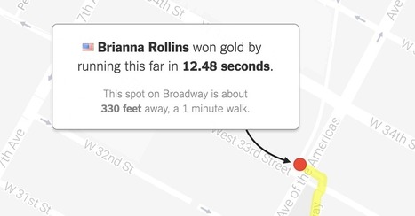
"What would Olympic races look like if they took place near you? Enter your address below to find out, or keep clicking the green button to explore races that begin in where you live."

No comment yet.
Scooped by Skuuppilehdet
Scoop.it!

Petra, Jordan: Huge monument found 'hiding in plain sight'

Petra, Jordan: Huge monument found 'hiding in plain sight' | Human Interest | Scoop.it

"Two archaeologists, who recently published their findings in the American Schools of Oriental Research, used Google Earth satellite images and drone photography to identify the outline of an enormous monument buried beneath sand and time at the UNESCO World Heritage site in Jordan."  --Motherboard

Zavier Lineberger's curator insight, March 29, 2018 3:38 PM
(Middle East) Using modern technology, archaeologists have discovered a new monument hidden underground in Petra. The find, dated around 150 B.C., is thought to be a ceremonial site with two platforms, pottery. columns, and a staircase carved out of stone. It is amazing that there are still new finds like this in the 21st century, but the history of the Middle East is so incredibly old, with so many extinct civilizations, that archaeologists will probably keep making new breakthroughs.
brielle blais's curator insight, April 1, 2018 4:40 PM
Physical geography can be really cool as understanding the current land helps to also understand the past. Researchers finding new monuments like this in Petra shows the importance of knowing the land around you, or someplace important like where the UNESCO World Heritage Site. 
Laurie Ruggiero's curator insight, May 29, 2018 5:30 PM
Unit 1
Rescooped by Skuuppilehdet from Human Geography is Everything!
Scoop.it!

Why Geography Matters . . . But Is So Little Learned

Why Geography Matters . . . But Is So Little Learned | Human Interest | Scoop.it

I will once again preach to the choir, but with the hope that this will arm you with resources to use in discussions with administrators and colleagues in the fight against geographic ignorance.  This article by Walter McDougall (2003 by Orbis) is worth reviewing and is a good reading assignment to start the school year.  The link is to a PDF version of the article. 


Via Scarpaci Human Geography
No comment yet.
Rescooped by Skuuppilehdet from HOMEHISTORY
Scoop.it!

Man of the world

Man of the world | Human Interest | Scoop.it

"On why a Prussian scientific visionary should be studied afresh...In a superb biography, Andrea Wulf makes an inspired case for Alexander von Humboldt to be considered the greatest scientist of the 19th century. Certainly he was the last great polymath in a scientific world which, by the time he died in Berlin in 1859, aged 89, was fast hardening into the narrow specializations that typify science to this day. Yet in the English-speaking world, Humboldt is strangely little-known."


Via Ben Salve
No comment yet.
Scooped by Skuuppilehdet
Scoop.it!

Why Mercator for the Web? Isn’t the Mercator bad?

Why Mercator for the Web? Isn’t the Mercator bad? | Human Interest | Scoop.it

"As you may know, Google Maps uses the Mercator projection. So do other Web mapping services, such as Bing Maps and MapQuest. Over the years I’ve encountered antipathy toward the use of the Web Mercator from map projection people. I know of two distinct schools of opposition. One school, consisting of cartographic folks and map aficionados, thinks the Mercator projection is 'bad': The projection misrepresents relative sizes across the globe and cannot even show the poles, they are so inflated. The other school, consisting of geodesy folks, thinks mapping services have corrupted the Mercator projection, whether by using the wrong formulæ for it or by using the wrong coordinate system for it."

Rescooped by Skuuppilehdet from AP HUMAN GEOGRAPHY DIGITAL STUDY: MIKE BUSARELLO
Scoop.it!

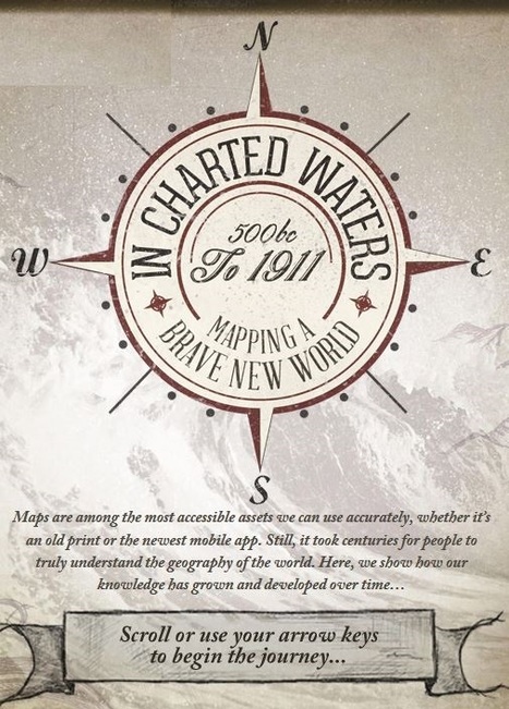
Evolution of the World Map

Evolution of the World Map | Human Interest | Scoop.it
Use our interactive In Charted Waters tool which shows information & visuals on how our knowledge of the world map has evolved.

Via Michael Miller, Mike Busarello's Digital Storybooks
Robert Slone's curator insight, February 25, 2015 7:23 AM

This interactive map is phenomenal teaching tool that would be great for teaching elementary school children introductory geography,

Luis Cesar Nunes's curator insight, February 26, 2015 7:14 AM

History of maps

Samuel Meyer's curator insight, March 23, 2015 12:00 PM

It is notable that the world's map has changed much since the advent of cartography, and many believed that the Americas were part of Asia. This is represented in the map.

Scooped by Skuuppilehdet
Scoop.it!

15 before-and-after images that show how we're transforming the planet

15 before-and-after images that show how we're transforming the planet | Human Interest | Scoop.it
We've dammed mighty rivers, built hundreds of artificial islands, and made the world's fourth-largest lake disappear.
Courtney Barrowman's curator insight, May 21, 2015 10:02 AM

Summer reading KQ2, How have humans altered Earth's environment? key concepts- remote sensing, land use

Gregory Stewart's curator insight, August 29, 2015 9:32 AM

Spatial Perspective!

Scooped by Skuuppilehdet
Scoop.it!

Earth From the ISS

"Watch along with Expedition 38 crew members Mike Hopkins and Rick Mastracchio as they look at various cities across the globe from the vantage point of the cupola on board the International Space Station."  


Tags: mapping, perspective, images, remote sensing, geospatial, unit 1 Geoprinciples.

No comment yet.
Scooped by Skuuppilehdet
Scoop.it!

Alexander von Humboldt

"Have you heard of Alexander von Humboldt? Not likely. The geologist turned geographer and South American explorer was a bit of an 18th century super scientist, traveling over 24,000 miles to understand the relationship between nature and habitat. George Mehler details Humboldt’s major accomplishments and why we should care about them today. See this TED ED lesson plan that accompanies the video."

Alyssa Dorr's curator insight, December 16, 2014 6:39 PM

I had not heard of Alexander Von Humbboldt before watching this video. He is said to be one of the most amazing scientists to ever live. More places around the world have been named after him than any other person. His name was lost in history so this is why many people are not familiar with him. He started off as a geologist, then he began a scientific five year journey from 1799-1804. His journey was long, dangerous at some times, and very interesting to hear about. He travel through mountains, across oceans, and through villages. For one thing, he was the first explorer to witness preparation of the curare plant, which was used for poison arrows. He recognized the importance of the cinchona tree, who's bark contains quinine, a malaria killer. He also discovered the ocean current which eliminates rainfall on the coast of Peru. To record air pressure, he climbed to the top of one of the tallest volcanoes, Mount Chimborazo. His total journey consisted of about 2400 miles, which is reality is equal to the circumference of the Earth.

Danielle Lip's curator insight, February 10, 2015 8:42 PM

This video was quite interesting because I had never heard of Alexander von Humboldt, yet this great scientist founded many different important facts that are beneficial and helped to find with the preparation of the Curare Plant which is in poisonous arrows and discovered the ocean current on South America. Without Humboldt South America might have been at a lose for some objects and geographical information. Everyone has an impact in geography and geology, yet Humboldt helped to create contour maps which happened different patterns, everyone builds off of others ideas. 

Kristin Mandsager San Bento's curator insight, March 5, 2015 3:58 PM

Nope, never heard of him.  Humboldt did some extraordinary things though.  I'm surprised we don't hear more about him in education.  I've definitely heard of Darwin though.  It's interesting what we decide is relevant or who is relevant in history.