

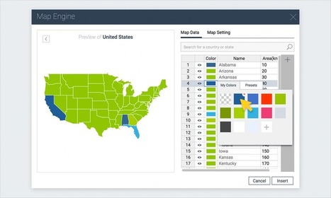

A step-by-step tutorial on how to create an interactive map with Visme, a free online infographic and presentation tool.
Get Started for FREE
Sign up with Facebook Sign up with X
I don't have a Facebook or a X account


 Your new post is loading...
 Your new post is loading...
Your new post is loading...
A step-by-step tutorial on how to create an interactive map with Visme, a free online infographic and presentation tool. 

Tom Cockburn's curator insight,
December 13, 2016 3:55 AM
Create your own maps

António Leça Domingues's curator insight,
December 19, 2016 6:44 AM
Criar um mapa interativo com Visme.

Bart van Maanen's curator insight,
December 19, 2016 10:02 AM
Mooie tool om een kaart van data te voorzien.
Sign up to comment

War, sectarian violence, and famine have forced more than 50 million people from their homes—the largest number of displaced people since World War II.
Skuuppilehdet's insight:
Here are two excellent ESRI StoryMaps about the Syrian refugee crisis; these are two very good examples of a great web maps.
Tags: GIS, ESRI, mapping, cartography, geospatial, edtech, Syria, political, refugees.

Mr. D's Social Studies Classroom's curator insight,
March 2, 2016 5:34 PM
Here are two excellent ESRI StoryMaps about the Syrian refugee crisis; these are two very good examples of a great web maps. 'The Uprooted' (focused more on Syria).Epicenter of a Deepening Refugee Crisis (puts Syria into larger global patterns).
Tags: GIS, ESRI, mapping, cartography, geospatial, edtech, Syria, political, refugees. 
malbert's curator insight,
March 4, 2016 1:30 AM
Here are two excellent ESRI StoryMaps about the Syrian refugee crisis; these are two very good examples of a great web maps. 'The Uprooted' (focused more on Syria).Epicenter of a Deepening Refugee Crisis (puts Syria into larger global patterns).
Tags: GIS, ESRI, mapping, cartography, geospatial, edtech, Syria, political, refugees. 
Rachel Stutzman's curator insight,
March 11, 2016 10:28 AM
Here are two excellent ESRI StoryMaps about the Syrian refugee crisis; these are two very good examples of a great web maps. 'The Uprooted' (focused more on Syria).Epicenter of a Deepening Refugee Crisis (puts Syria into larger global patterns).
Tags: GIS, ESRI, mapping, cartography, geospatial, edtech, Syria, political, refugees.

Maps. They’ve been around longer than photographs. They’ve defined empires,guided explorers, told stories, and captured the imagination of many a hopeful traveler for years. While most appreciate the beauty and power of a good map, few recognize the dynamic and vital applications they have today.
Tags: mapping, 201, edtech, cartography. Via Mike Busarello's Digital Storybooks

All the latest news on the the search for the lost ships of the Franklin Expedition, as well as information on past searches, the technology used in the searches, historical information about the Franklin Expedition itself, and much more. Via Mike Busarello's Digital Storybooks

Jacob McCullough's curator insight,
March 23, 2015 6:46 PM
I am totally into archeology and the study of the past I feel it is valuable for all people to learn as much they can from past mistakes and success

Join our FREE GIS Day World Record mapping event taking place during Geography Awareness week (Nov 17th -21nd 2014, video with more details). With a local to global perspective, we want students to map their thoughts and feeling about their local area.
They can add their data to a global map that is shared with the world. Help us achieve our goal of having 100,000 students take part globally. The event will provide great opportunities for:
Using the latest GIS technologySpatial thinkingData analysis with GISMap designConnecting students with their peers worldwide Tags: mapping, GIS, K12, ESRI, geospatial, edtech.
Via Mike Busarello's Digital Storybooks
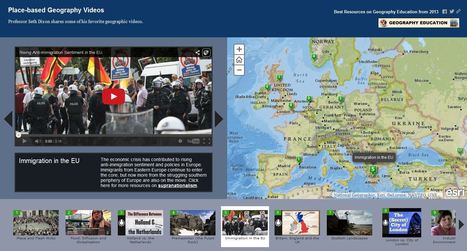
Professor Seth Dixon shares over 50 of his favorite geography videos in this online map http://bit.ly/KDY6C2

Melissa Marie Falco-Dargitz's curator insight,
November 3, 2014 12:02 PM
It was nice to see where everything was happening. I hope it gets updated to more current events. I wish we had something like this when we were looking at the invasion of Kuwait. 
Caroline Ivy's curator insight,
March 15, 2015 5:19 PM
Seth Dixon uses ArgGIS to juxtapose maps with the location a video is associated with.
This idea has crossed my mind before. Now, a video can be contemplated with the spatial accuracy needed. This connects events to a place, and can help students more fully grasp the geospatial distribution of events. 
Nita Ardi's curator insight,
January 14, 2019 12:16 PM
Great resource for classroom and information to get kids going.
|
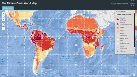
"Obsessed as we are with cartography we in Staridas Geography perceive any aspect of the actual 3D World as a constant opportunity for another pretty map creation!" Via Alex Smiga

GTANSW & ACT's curator insight,
August 19, 2016 7:47 PM
Great map to discuss global distribution of biomes and links to climate 
Sally Egan's curator insight,
August 21, 2016 6:24 PM
Fun way for students to learn about the diverse climates around the world, by selecting a location on the map students are shown the climatic data of the selected place.
"Join Queen Rania Al Abdullah of Jordan and wander through the lost city of Petra in Street View http://goo.gl/ixZRa9 "

This website serves as an off-campus host for text, images, data and other web-based resources associated with the free eText, Introduction to Human Geography: A Disciplinary Approach.

Leoncio Lopez-Ocon's curator insight,
August 13, 2015 8:52 AM
Gracias a Seth Dixon accedo a este texto de acceso libre que es una interesante Introducción a la Geografía Humana. De fácil navegación se puede acceder a valiosa información textual, a imágenes, datos y otros recursos. Es un producto de Steven Graves, profesor de geografía en California State University, Northridge.
"Never doubt that a small group of thoughtful, committed citizens can change the world; indeed, it's the only thing that ever has." --Maragret Mead Via Courtney Barrowman

Kristin Mandsager San Bento's curator insight,
May 1, 2015 3:55 PM
I love the notion and sometimes agree with this idea. But at the same time it has to be sustained by the people. It's this exciting idea to be a part of something, but that wears off quickly for a lot of people. Then they are on to the next thing. It would be nice if everyone would pick one cause and stay with it for atleast a year. Maybe make this your New Years Resolution instead of hitting the gym. 
Avery Liardon's curator insight,
May 20, 2015 10:43 AM
Very intriguing way to summarize the world and wrap up human geography. Reminds me of the pale blue dot speech, and really captures the big idea of how people and geography shape the world we live in.

I have a confession to make; I’m a map geek. Even as a kid watching Raiders of the Lost Ark, I was fascinated by the map they used to segue between scenes to show Indiana Jones’ travels.

Adriene Mannas's curator insight,
December 12, 2014 11:05 AM
Unit 1 Nature and Perspectives of Geography
This article shows that people often still love maps. Some people grow out of map loving as a teenager and it is not as popular for people to like them anymore. This article tells haw maps are being pushed out of style and how it is hurting our intelligence.
This ties into human geography through the fact that it is needed to have a passion for geographical thinking to even get into Human Geography. This shows how not learning about mas can drastically hurt and is drawing away from the geographical field. 
Jason Schneider's curator insight,
January 27, 2015 12:02 AM
I'm taking World Regional Geography because I love maps as well. I am more of a visual learner rather than a verbal learner. In my spare time, I like to map out my dream restaurants and my dream home and turning it into a map itself helps me understand locations in the easiest way. It also helps me identify one area's size and shape in comparison to other's. |


