Human Interest
198.8K views | +0 today
Follow
Human Interest
Your new post is loading...
Scooped by Skuuppilehdet
Scoop.it!

Pacific nation Tuvalu has grown by 73 hectares over 40 years

Pacific nation Tuvalu has grown by 73 hectares over 40 years | Human Interest | Scoop.it

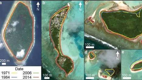
"The tiny Pacific nation of Tuvalu – once thought to be under threat from rising sea levels – has grown the size of California's Disneyland over the past 40 years. It's mostly thanks to waves dumping extra sediment, sand and gravel on shore lines, according to research by Auckland University scientists. The study, published in the Nature Communications journal on Friday, was the first in-depth look at how much each of Tuvalu's 101 islands have changed over the decades."


Tags: Oceaniawatercoastal, environment, physical, geomorphology, erosiongeology, landforms.

No comment yet.
Scooped by Skuuppilehdet
Scoop.it!

Africa’s Charcoal Economy Is Cooking. The Trees Are Paying.

Africa’s Charcoal Economy Is Cooking. The Trees Are Paying. | Human Interest | Scoop.it
In Madagascar, the booming charcoal business is contributing to deforestation and may exacerbate the effects of global warming.
Launceston College Geography's curator insight, June 13, 2017 9:51 PM

Deforestation drivers

Alex Smiga's curator insight, August 9, 2017 9:41 AM
If we know that furthering education and economic opportunities will help alleviate the problems present here, why aren't we as a planet seeing that they are implemented? 
brielle blais's curator insight, May 1, 2018 10:23 PM
Charcoal has become the unlikely hero of the informal economy of Africa. This is a positive for the economy. However, this is not a positive for the environment. Deforestation has become a large issue since the boom of more people using charcoal. This will speed up the issue of climate change. This post shows the negative and positives a product can have involving geography.
Scooped by Skuuppilehdet
Scoop.it!

Floods might have doomed prehistoric American city

Floods might have doomed prehistoric American city | Human Interest | Scoop.it
Cahokia settlement's decline began in 1200, around time of major Mississippi River surge.
No comment yet.
Rescooped by Skuuppilehdet from AP HUMAN GEOGRAPHY DIGITAL STUDY: MIKE BUSARELLO
Scoop.it!

Why Do Rivers Curve?


Via Mike Busarello's Digital Storybooks
Sally Egan's curator insight, December 7, 2014 4:27 PM

A very siual form using simple language to explain the meandering of rivers. Applicable to the course work on Hydrosphere.

Jason Schneider's curator insight, January 27, 2015 12:15 AM

So pretty much, the water controls rivers rather than particles controlling the river. Also, it appears that the motion and strength of the water causes rivers to bend and form in different curves. I'd like to think of it as a ball bouncing from side to side and every time it touches the border land of a river, it expands to the opposite side. However, when the water flow is hitting the side of a river, the opposite side is not getting any force from the water flow. In that case, the side that is not getting hit by the water flow slowly moves to the side that is being by the water flow causing river curves.

GTANSW & ACT's curator insight, June 1, 2015 2:07 AM


The geomorphic processes that produce landforms, including a case study of at least one landform 


Rescooped by Skuuppilehdet from AP HUMAN GEOGRAPHY DIGITAL STUDY: MIKE BUSARELLO
Scoop.it!

Eerie Landforms

Eerie Landforms | Human Interest | Scoop.it

Utah's Fantasy Canyon features mudstone eroded into bizarre shapes. This one's called "Flying Witch". #Halloween


Tags: physical, geomorphology, erosion, landforms, Utah.


Via Mike Busarello's Digital Storybooks
No comment yet.
Scooped by Skuuppilehdet
Scoop.it!

This is what Louisiana stands to lose in the next 50 years

This is what Louisiana stands to lose in the next 50 years | Human Interest | Scoop.it
The USGS says sea-level rise and sinking could claim up to 4,677 square miles of land along the coast if the state doesn’t implement major restoration plans.
James Hobson's curator insight, September 15, 2014 9:23 AM

(North America topic 2)
This interactive map is an excellent tool for researching how low-lying delta areas such as southern Mississippi have changed over recent years, and for what underlying reasons. Although human activity has been largely responsible for the loss of valuable marshland (land development, canals, levees), it's nice to know that in some cases human activity has actually helped to promote it, even if it was not originally intended to do so.

It makes you think: what other unintended consequences human actions are having on the environment in other places and on other scales?

Giselle Figueroa's curator insight, September 28, 2014 9:24 PM

Is very crazy that soon these land will be gone. What really makes me worry is that in a few years all these land in Louisiana will be gone, what is going to happen to all these people who is living right know in these areas? What action government will take? This is a very worrying situation.

Jake Red Dorman's curator insight, November 13, 2014 11:04 AM

If I lived in Louisiana, I wouldn’t settle down near the coast. 2,000 square miles will be lost in about 80 years. The water will have risen to 4.3 feet, and Louisiana has an average height of 3 feet. That leaves everything outside of the protective levees underwater in due time. Many pipelines that serve 90% of the nation’s offshore energy production and 30% of its gas and oil supply that goes to 31 different states and over 2 million people will all need to find a new place to live if this continues. Once home to 700 people south of New Orleans is now home to nearly 15 residents. The water level has already been ruining homes for people in Louisiana.  

Scooped by Skuuppilehdet
Scoop.it!

Block-Long Sinkhole Swallows Cars in Baltimore

Block-Long Sinkhole Swallows Cars in Baltimore | Human Interest | Scoop.it

"A block-long sinkhole opened up in a residential neighborhood in rain-soaked Baltimore on Wednesday, devouring cars and forcing the evacuation of several houses."

Jim Doyle's curator insight, May 9, 2014 10:57 PM
Block-Long Sinkhole Swallows Cars in Baltimore
Scooped by Skuuppilehdet
Scoop.it!

Rivers from Above

Rivers from Above | Human Interest | Scoop.it
Get a unique view of these rivers beyond the banks.Photo editing by Lia Pepe
Woodstock School's curator insight, February 25, 2014 5:01 AM

The Art of Geography

Mark Burgess's curator insight, February 26, 2014 6:26 AM

Awesome rivers. i love a good river.

ok's curator insight, September 23, 2014 5:45 AM

esrdcfvtgbhyjnkmstgyb weiweeee

Scooped by Skuuppilehdet
Scoop.it!

Sinkhole looks like an abyss, recharges aquifer

Sinkhole looks like an abyss, recharges aquifer | Human Interest | Scoop.it
At this sinkhole, about 500 cubic feet of water per second is disappearing into the earth, the equivalent of an Olympic-sized swimming pool every three minutes, according to an engineer with the Edwards Aquifer Authority. For as much water reaches the aquifer at this spot, far more infiltrates through porous rock across South-central Texas.
No comment yet.
Scooped by Skuuppilehdet
Scoop.it!

Large Flash Flood

"A nice flood rolled down Johnson Canyon (southern Utah) on July 6th, 2015."

No comment yet.
Rescooped by Skuuppilehdet from AP HUMAN GEOGRAPHY DIGITAL STUDY: MIKE BUSARELLO
Scoop.it!

Simulation of the Oso Landslide

Simulation of the Oso Landslide | Human Interest | Scoop.it

"The large landslide that occurred in March near Oso, Washington was unusually mobile and destructive."


Via Mike Busarello's Digital Storybooks
Kristin Mandsager San Bento's curator insight, January 27, 2015 4:50 PM

This seems like a useful tool to a degree.  But if we could actually simulate every destructive event then we would be miracle workers.  This was a sad event.  We have left such an imprint on the earth that it's starting to fight back.  We need to be more aware and careful with the one planet we have.  Climate changes are in the news more and more.  We can't ignore climate changes anymore.  

Rescooped by Skuuppilehdet from AP HUMAN GEOGRAPHY DIGITAL STUDY: MIKE BUSARELLO
Scoop.it!

Meandering Stream Time Lapse

The most viral images on the internet, curated in real time by a dedicated community through commenting, voting and sharing.

Via Mike Busarello's Digital Storybooks
Jake Red Dorman's curator insight, November 25, 2014 1:24 PM

El Sire Reserve in Peru is a river that has been monitored over the last 28 years. Every time I watch this short 6 second clip, I learn something different about how this river has changed. On the bottom of the screen, just past half way, the river just takes a huge short cut and cuts over and connects to a different part of the same river. This happens on the whole river too. there are 8 or 9 huge bends and curves in the river but by the end in 2012 there are only about 3 to 4 bends and curves. For some reason the water is taking short cuts and just leaving the spaces where the water used to run through and leaving it dry.  

Mathijs Booden's curator insight, January 20, 2016 8:35 AM

This is such a tangible way of showing things that seem abstract on a static map.

Pieter de Paauw's curator insight, February 15, 2016 6:28 AM

Een natuurlijk meanderende rivier

Rescooped by Skuuppilehdet from U.S HISTORY SHACK : MIKE BUSARELLO
Scoop.it!

Louisiana Loses Its Boot

Louisiana Loses Its Boot | Human Interest | Scoop.it
The boot-shaped state isn’t shaped like that anymore. So, we revised its iconic outline to reflect the truth about a sin…

Via Mike Busarello's Digital Storybooks
James Hobson's curator insight, September 18, 2014 10:52 AM

(North America topic 7)
Just like geography and history textbooks become obsolete the day they're published (thanks to Professors Dixon and Bonin for the phrase!), the same can be said for maps and icons.

This article uses the example of Louisiana's state highway signs, which show the outline of the state... well, according to data from the 1930s. While an updated sign isn't as pretty, it does bring about the truth that the landscape is changing, and on a larger scale this is true for the entire world, especially with influence from development and climate change.
However, I can relate to the other side of the argument too. Tossing the old LA symbol would toss a historical reminder of what once was. The same can be said for New Hampshire's Old Man of the Mountain road signs and license plates. I'd hate to see the profile removed, especially since what is symbolizes still lives on in the hearts of many residents and visitors, including myself.

Scooped by Skuuppilehdet
Scoop.it!

Mystery of Death Valley's 'Sailing' Stones Solved

Mystery of Death Valley's 'Sailing' Stones Solved | Human Interest | Scoop.it
There's a place in Death Valley National Park where a mystery that has puzzled scientists and park visitors for decades finally has been solved.
Riaz Ahmad Baboojee's curator insight, August 29, 2014 12:59 AM

Think

Greg Russak's curator insight, August 29, 2014 9:30 AM

It's probably not what you think. It wasn't what I thought.....then again, I had no idea what was happening.

Jake Red Dorman's curator insight, October 29, 2014 1:46 PM

It's amazing to see that even though we have been on this planet for so long, there are stilll mysteries such as this. Tjis could have taken year s to solve but looking at the picture in the slides at the bottom of the article, it seems like this group of scientists knew exactly how to figure this out. this all happens becasue of geography and where these rocks are in the world that make them move around. Iis in a dried up lake pond that freezes over at night to create a layer of ice strong enough to help the rocks move around at night. This discovery took 2 whole years to figure out, but was vey much worth it in the end. 

Scooped by Skuuppilehdet
Scoop.it!

Largest glacier calving ever filmed

"On May 28, 2008, Adam LeWinter and Director Jeff Orlowski filmed a historic breakup at the Ilulissat Glacier in Western Greenland. The calving event lasted for 75 minutes and the glacier retreated a full mile across a calving face three miles wide. The height of the ice is about 3,000 feet, 300-400 feet above water and the rest below water."


Tags: physical, geomorphology, landforms, erosion, climate change, Greenland.

Ms. Harrington's curator insight, April 13, 2014 10:37 AM

More information at www.chasingice.com

Maricarmen Husson's curator insight, April 13, 2014 2:15 PM

Adam LeWinter and Director Jeff Orlowski filmed a historic breakup at the Ilulissat Glacier in Western Greenland

Rescooped by Skuuppilehdet from The Geo Feed
Scoop.it!

Gravity...

Gravity... | Human Interest | Scoop.it

"The video clip shows the cliff where the fall initiated, near the ledge close to the skyline.  Then, below the ledge, you can see the talus cone, which are rocky bits along the slope. The really large boulders that fell down and ruined the house have carved out soil ruts as the boulders rolled downhill." http://geographyeducation.org/2014/01/30/gravity/


Via geo-pickmeup.com
Giovanni Sonego's curator insight, January 31, 2014 7:18 AM

Una decina di giorni fa, il 21 gennaio 2014, è franato un torrione di roccia posto sopra un'abitazione a Termeno (Tramin), in Alto Adige.


Devastati campi, attrezzature, vigneti - a Tramin si produce i famoso Traminer - e tanta paura per la famiglia del sig. Herbert Trebo che ha visto uno dei massi fermarsi a pochi metri dalla casa. 


Qui trovate un filmato che riprende dall'alto la zona, evidenziando la zona del distacco e gli effetti devastanti dei massi rotolati e del terreno franato.