


"Unchecked development remains a priority in the famously un-zoned city, creating short-term economic gains for some, but long term flood risk for everyone."
Get Started for FREE
Sign up with Facebook Sign up with X
I don't have a Facebook or a X account


 Your new post is loading...
 Your new post is loading...
Your new post is loading...
"Unchecked development remains a priority in the famously un-zoned city, creating short-term economic gains for some, but long term flood risk for everyone." 
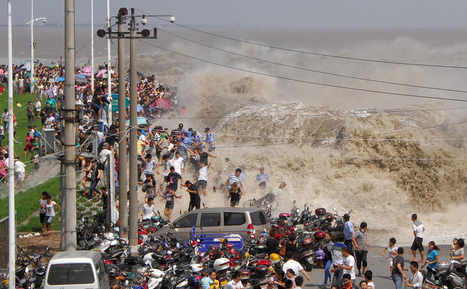
For hundreds of years, on the eighth month of the lunar calendar, people have gathered along the shores of China’s Qiantang River at the head of Hangzhou Bay to witness the waves of its famous bore tide. Higher-than-normal high tides push into the harbor, funneling into the river, causing a broad wave that can reach up to 30 feet high. If the waves surge over the banks, spectators can be swept up, pushed along walkways or down embankments. Below, I’ve gathered images from the past few years of the Qiantang bore tides.

Geographers make a distinction between site and situation as they consider the underlying foundation of a place. Few cities represent such a wide chasm between these two aspects as does New Orleans. The situation, or the answer to why does a place exist, was imperative. The Mississippi River was a major artery for the North American continent. As first the Europeans and then the Americans assumed control of the area, a port was essential at the mouth of this river. But the site, the response to where a city is placed, continues to confound. Few environments were or are more inhospitable to human habitation. Poor soil, disease, floods, and hurricanes are constant threats that have plagued the city for over three centuries. But the why trumped the where and hence the paradox of New Orleans persists. Via CT Blake

"It's difficult to comprehend the ridiculous amounts of water that have fallen in such a short time in a state that, until recently, had been in the grip of a historic drought. But one place to start would be to look at reservoir levels in the state. In the past 30 days, Texas reservoirs have gone from being 73 percent full to 82 percent full, according to data maintained by the Texas Water Development board. All told, about 8 million acre-feet of water have flowed into the state's reservoirs." Via Scott Langston
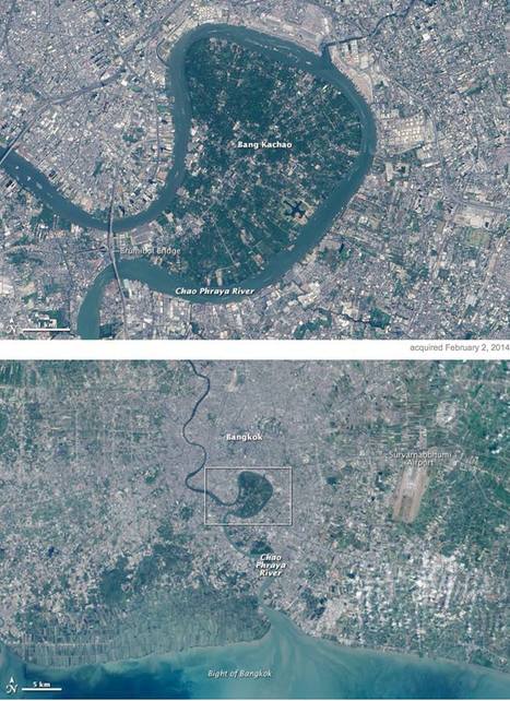
"In the heart of Thailand’s most populous city, an oasis stands out from the urban landscape like a great “green lung.” That’s the nickname given to Bang Kachao—a lush protected area that has escaped the dense development seen elsewhere in Bangkok. The city is built on the alluvial plain of the Chao Phraya River. Toward the southern end, near the Gulf of Thailand, is an old meander that never quite formed an oxbow lake. That meander traces the boundary of Bang Kachao, which TIME magazine once called the 'best urban oasis' in Asia. According to a travel story in The New York Times, Bang Kachao is gaining popularity among tourists lured by bike tours, a floating farmers’ market, and the relaxed atmosphere." Tags: physical, fluvial, remote sensing, land use, Thailand, Southeast Asia, urban ecology. Via GTANSW & ACT

Savannah Rains's curator insight,
May 27, 2015 1:51 AM
This scoop shows an example of built environmental space. The highly urban and crowded Thailand has little green space. So why is this massive green park looking landmass there? Its a strictly environmental section of land to help water flow into the ocean. The people call it the "green lung" because its plants give off oxygen and provide a contrast from its urban sprawl. This article shows the importance that should be placed on having more strictly environmental places in big cities. 
Chris Costa's curator insight,
November 9, 2015 2:06 PM
It's interesting to see the mixture of natural and manmade landscapes in this image. Humans have an enormous influence on the world around us- we have moved entire rivers for our own purposes, reshaped entire regions. In China, we have literally made it rain. Therefore, it's nice to see remnants of the rich environments that used to cover the urban sprawls of many of the world's largest cities, like Central Park in New York. Bang Kachao in Bangkok is another example of this, a reminder of the richness of the region before it was overwhelmed by the urban development that has characterized Bangkok over the previous century. The oasis serves as a valuable tourist attraction, as Westerners come to enjoy the bike trails and small farming community within Thailand's green lung. Leave it to hipsters to travel halfway across the globe just to enjoy nature within the confines of one of the world's largest cities. 
brielle blais's curator insight,
May 3, 2018 3:55 PM
This showcases how important physical geography is. This "green lung" breaks up the high urbanized Bangkok. This helps the environment thrive and helps to cut down of emissions that affect climate change which is a problem in some areas.

Sally Egan's curator insight,
December 7, 2014 4:27 PM
A very siual form using simple language to explain the meandering of rivers. Applicable to the course work on Hydrosphere. 
Jason Schneider's curator insight,
January 27, 2015 12:15 AM
So pretty much, the water controls rivers rather than particles controlling the river. Also, it appears that the motion and strength of the water causes rivers to bend and form in different curves. I'd like to think of it as a ball bouncing from side to side and every time it touches the border land of a river, it expands to the opposite side. However, when the water flow is hitting the side of a river, the opposite side is not getting any force from the water flow. In that case, the side that is not getting hit by the water flow slowly moves to the side that is being by the water flow causing river curves. 
GTANSW & ACT's curator insight,
June 1, 2015 2:07 AM
The geomorphic processes that produce landforms, including a case study of at least one landform

The boot-shaped state isn’t shaped like that anymore. So, we revised its iconic outline to reflect the truth about a sin… Via Mike Busarello's Digital Storybooks

James Hobson's curator insight,
September 18, 2014 10:52 AM
(North America topic 7) This article uses the example of Louisiana's state highway signs, which show the outline of the state... well, according to data from the 1930s. While an updated sign isn't as pretty, it does bring about the truth that the landscape is changing, and on a larger scale this is true for the entire world, especially with influence from development and climate change. |
"Watch salmon race across the road on their way to spawn; for more footage, watch this extended version."
GTANSW & ACT's curator insight,
December 17, 2016 11:45 PM
Sometimes the natural world finds ways to adapt to human environmental changes. Useful when studying inland water / rivers for the option study.

On occasion, we are reminded of how utterly captivating and gorgeous nature is, its visual poetry surrounds us. It just takes a step back, a shift in perspective, to realize how amazing the constructs of this planet are; it’s a beautiful constant balance between order and entropy. Case in point, what appears to be well-crafted, intricate abstract paintings, or works of art, are in reality, mindblowing aerial images of Iceland."

Joaquín del Val's curator insight,
May 27, 2016 1:20 PM
Espectaculares imágenes de canales fluviales en Islandia
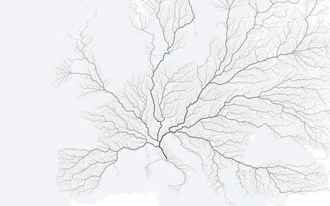
"As the saying goes, 'All roads lead to Rome.' Folks at the moovel lab were curious about how true this statement is, so they tested it out. They laid a grid on top of Europe, and then algorithmically found a route from each cell in the grid to Rome, resulting in about half a million routes total. Yep, there seems to be a way from Rome from every point."
Tags: fluvial, mobility, transportation, mapping. Via Mike Busarello's Digital Storybooks

Gilbert C FAURE's comment,
January 24, 2016 11:09 AM
a new geography of europe! fascinating for politicians
Gilbert C FAURE's curator insight,
January 24, 2016 11:10 AM
une nouvelle géographie de l'Europe! pour les politiques!! 
Leonardo Wild's curator insight,
January 24, 2016 1:00 PM
But many roads didn't leave Rome ... a small detail that has been lost to history.
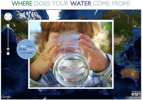
This interactive map documents where 443 million people around the world get there water (although the United States data is by far the most extensive). Most people can't answer this question. A recent poll by The Nature Conservancy discoverd that 77% of Americans (not on private well water) don't know where their water comes from, they just drink it. This link has videos, infographics and suggestions to promote cleaner water. This is also a fabulous example of an embedded map using ArcGIS Online to share geospatial data with a wider audience.
Tags: GIS, water, fluvial, environment, ESRI, pollution, development, consumption, resources, mapping, environment depend, cartography, geospatial. Via GTANSW & ACT

Cahokia settlement's decline began in 1200, around time of major Mississippi River surge.
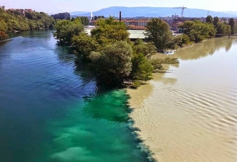
"Confluences occur wherever two streams come together. If the gradient is low (i.e., nearly level) and the properties of the two streams are very different, the confluences may be characterized by a dramatic visible distinction as the mixing occurs only slowly." Tags: physical, fluvial, geomorphology, erosion, landscape.

Sylvain Rotillon's curator insight,
January 7, 2015 5:47 AM
Wonderful pictures of rivers confluences
The most viral images on the internet, curated in real time by a dedicated community through commenting, voting and sharing. Via Mike Busarello's Digital Storybooks

Jake Red Dorman's curator insight,
November 25, 2014 1:24 PM
El Sire Reserve in Peru is a river that has been monitored over the last 28 years. Every time I watch this short 6 second clip, I learn something different about how this river has changed. On the bottom of the screen, just past half way, the river just takes a huge short cut and cuts over and connects to a different part of the same river. This happens on the whole river too. there are 8 or 9 huge bends and curves in the river but by the end in 2012 there are only about 3 to 4 bends and curves. For some reason the water is taking short cuts and just leaving the spaces where the water used to run through and leaving it dry. 
Mathijs Booden's curator insight,
January 20, 2016 8:35 AM
This is such a tangible way of showing things that seem abstract on a static map.
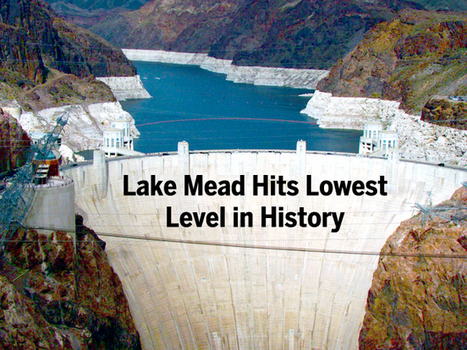
"The largest reservoir in the U.S. falls to its lowest water level in history, Nevada State Sen. Tick Segerblom introduced a bill title and issued a press release on July 8 calling for an 'independent scientific and economic audit of the Bureau of Reclamation’s strategies for Colorado River management.'"
This week’s history-making, bad-news event at Lake Mead has already triggered lots of news stories, but almost all of these stories focus on the water supply for Las Vegas, Phoenix and California. But what about the health of the river itself?
Tags: physical, fluvial, drought, water, environment.

Tom Franta's curator insight,
July 12, 2014 11:40 AM
Many geographers are aware that future water resource issues in the American Southwest will have political, cultural, and social impacts. What do you believe to be some approaching concerns after reading this article? |


Houston's development boom and reduction of wetlands leave region prone to more severe flooding. Here is a great map of the change in impervious surfaces in the region from 1940 to 2017--when you combine that with record-breaking rainfall the results are catastrophic. But a local understanding of place is critical and this viral post--Things non-Houstonians Need to Understand--is pretty good.
Tags: physical, fluvial, water, coastal, urban, planning, transportation, architecture.
Un dossier sur les inondations à Houston (en anglais). La présentation est très originale.