


While Indonesia has taken steps to address the worst forest fires in living memory, a new palm oil alliance with Malaysia threatens to take a giant leap back.
Via dilaycock
Get Started for FREE
Sign up with Facebook Sign up with X
I don't have a Facebook or a X account


 Your new post is loading...
 Your new post is loading...
Your new post is loading...
While Indonesia has taken steps to address the worst forest fires in living memory, a new palm oil alliance with Malaysia threatens to take a giant leap back. Via dilaycock 
No comment yet.
Sign up to comment

The Vault is Slate's history blog. Like us on Facebook, follow us on Twitter @slatevault, and find us on Tumblr. Find out more about what this space is all about here.

How do the products we buy affect the world’s rainforests? In the lead up to the Asia-Pacific Rainforest Summit held in Sydney this week, The Conversation is running a series on rainforest commodities…

At the recent UN Climate Summit in New York there was little in the way of new climate policy announcements, but 27 countries did sign a new forest agreement — the New York Declaration on Forests. Some… Via dilaycock
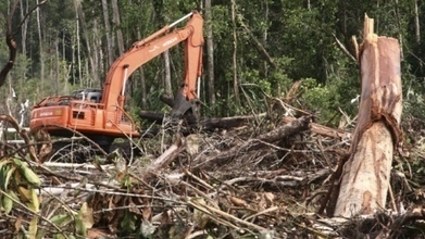
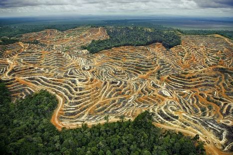
Indonesia has for the first time surpassed Brazil in clearing tropical forests and losses are accelerating despite a 2011 moratorium meant to protect wildlife and combat climate change, scientists said on Sunday. Via dilaycock

The federal and incoming Tasmanian governments are pushing ahead with moves to delist parts of Tasmania’s forest World Heritage, on grounds that the area includes “degraded” forest. But these “degraded… Via dilaycock

dilaycock's curator insight,
March 19, 2014 8:31 PM
Wouldn't it be safe to say that most World Heritage Areas have been degraded to some extent by the very fact that by being WHA they attract tourists (and all the associated development).

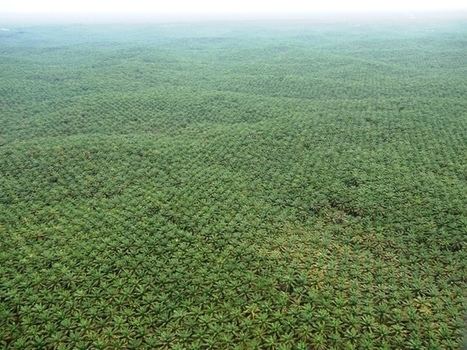
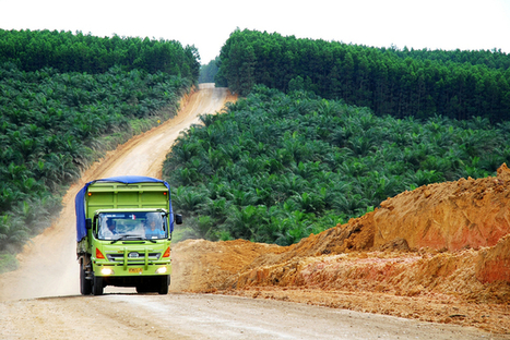
Indonesia is the world’s biggest destroyer of forests and four multinational corporations — APP, APRIL, Wilmar and Golden Agri Resources — have been responsible for much of it. Until recently these mega-corporations… Via dilaycock
|

The Vault is Slate's history blog. Like us on Facebook, follow us on Twitter @slatevault, and find us on Tumblr. Find out more about what this space is all about here.

How do the products we buy affect the world’s rainforests? In the lead up to the Asia-Pacific Rainforest Summit held in Sydney this week, The Conversation is running a series on rainforest commodities… Via dilaycock
Palm oil plantations have an overall negative impact on biodiversity, according to research released this week. The study, published in Nature Communications, found palm oil plantations are home to fewer… Via dilaycock
Oil palm plantations are a major threat to orangutans, but new initiatives for deforestation-free palm oil may help save them. Via dilaycock
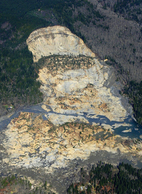
In recent decades the state allowed logging — with restrictions — on the plateau above the Snohomish County hillside that collapsed in last weekend’s deadly mudslide. Via dilaycock

Geofreak's curator insight,
April 3, 2014 1:39 PM
Mijnbouw en aardverschuivingen, een goede combinatie ...... 
PIRatE Lab's curator insight,
April 7, 2014 11:48 AM
There are several reasons for mudslides--some are purely a result of physical geography and others are related to land use patterns. This last week's mudslide in Washington state was a combination of the two and although this impacts one place (see on map), it is a good teaching moment to discuss the environmental impacts of land use patterns and resource extraction projects. As seen in this interactive, the river was cutting at the base of the hill, while loggers were clear-cutting at the top of the mountain. Trees help prevent erosion as the roots hold the soil in place--a critical piece to the puzzle in a very rainy climate. With $1 million worth of timber on the slope, logging companies persisted despite objections from the Department of Natural Resources and some restrictions (but in hindsight, those restrictions clearly were not enough).
View the impact in ArcGIS online: Before and After Swipe, LiDAR I and II, and Imagery.
Questions to Consider: Other than economic worth, what other ways are there to value and evaluate the environment? How could this landscape have been protected and managed better or was this mudslide inevitable? 
El Futuro deWaukesha's curator insight,
April 18, 2014 12:03 AM
Working on an Inquiry of recent natural disasters with first grader.
dilaycock's curator insight,
February 24, 2014 5:53 PM
A new high-resolution global map of forest loss and gain has been created with the help of Google Earth. The interactive online tool is publicly available and zooms in to a remarkably high level of local detail - a resolution of 30m. It charts the story of the world's tree canopies from 2000 to 2012, based on 650,000 satellite images by Landsat 7. In that time, the Earth lost a combined "forest" the size of Mongolia, enough trees to cover the UK six times.

Logging companies in PNG are using special agricultural leases to clear vast tracts of rainforest timber, on the promise of roads and economic development for remote villages. Via dilaycock
|


