Astronauts on the International Space Station took these images of cities at night. Note that up doesn’t necessarily mean north. All images: ESA/NASA
Via LEONARDO WILD, Mike Busarello's Digital Storybooks
Get Started for FREE
Sign up with Facebook Sign up with X
I don't have a Facebook or a X account


 Your new post is loading...
 Your new post is loading...
Your new post is loading...
Astronauts on the International Space Station took these images of cities at night. Note that up doesn’t necessarily mean north. All images: ESA/NASA Via LEONARDO WILD, Mike Busarello's Digital Storybooks 

Ivan Ius's curator insight,
March 28, 2017 8:44 AM
Geographic Thinking Concepts: Spatial Significance, Patterns and Trends

Alexander peters's curator insight,
April 11, 2017 9:07 AM
The article was about identifying city lights from the sky. I think that it was fun to do and guess them.
Sign up to comment
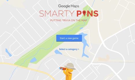
Smarty Pins is a Google Maps based geography and trivia game. Via Mike Busarello's Digital Storybooks
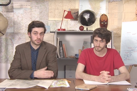
Mark Cooper-Jones and Jay Foreman, the Map Men, tap into a rich vein of geographical quirks to teach through comedy Via Mike Busarello's Digital Storybooks

Jeremy Hansen's curator insight,
August 29, 2016 12:43 PM
Holy heck these guys are good! I'd like to see more of these Map Men videos. I'm sure at least some of my 8th graders can appreciate some British wit.

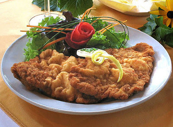
We take what is offered for daily celebration. Sometimes it tempts our palettes, other times not. There are even times when it takes some searching in order to put the two together for some foodie fun. Via Sharla Shults
April 13 is... Via Sharla Shults

Cartoons by John Atkinson. ©John Atkinson, Wrong Hands (by Wrong Hands) Via Mike Busarello's Digital Storybooks

Niall Conway's curator insight,
March 16, 2016 1:41 PM
Maybe this is not the next geographic model that will transform the discipline, but it is fun.
Tags: urban, economic, urban models, fun, art.

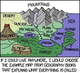
"What is on the other side of the Earth? Find out here."

Ignacio Garrido's curator insight,
October 20, 2015 8:17 AM
Exercise to do :
a) Explain what is the "antipodes" concept b) Find out the "antipodes" of one city in each continent c)If in one city is summer...what is the climate of their antipode city? d) Write 10 lines explaining what is the most like you about this map

Scott Greer's curator insight,
August 28, 2015 8:45 PM
All you need to know is that it is John Oliver....he's funny.
A weekly show where knowledge junkies get their fix of trivia-tastic information. This week, John shares 27 facts about maps.

Ashley Burleson's curator insight,
August 11, 2015 4:45 AM
This Mental Floss video is an entertaining rapid-fire hodgepodge of map trivia with some important educational content nicely nestled in there. This 99 Percent Invisible podcast is another 'ode to maps,' but this one is more poetic about the value of cartography and personal in how it explores the qualities they possess. Enjoy them both! Tags: mapping, trivia, cartography. 
Matt Davidson's curator insight,
August 11, 2015 7:43 AM
Maps are awesome - need I say more! This clip actually covers a significant amount on the power / influence of maps through history. 
Ruth Reynolds's curator insight,
August 11, 2015 7:59 PM
Very USA centric but entertaining and makes you think about the taken-for- granted use of maps. We do believe them!!
"How well do you know your Saskatchewan slang? At Insightrix in Saskatoon, Saskatchewan, we've got the prairies down flat!"

Jason Schneider's curator insight,
January 26, 2015 8:45 PM
I am absolutely fascinated by Earth's Physical Environments. What I like specifically about this map and most maps for that matter is that you won't find a lot of comfortable environments that introduce you to many environmental areas in real life. As long as I have the survival skills, I would love to live in a place where I can know what are Earth's Physical Environments.

"During the month of October, I take advantage of the pumpkin harvest to bring hands-on geography to my students. After spending a month becoming familiar with the location of the seven continents and the major bodies of water, each student is given a pumpkin to turn into a globe. Students paint the entire surface of the pumpkin blue to represent water. Next, they use pushpins to position and trace the outline of each continent onto their pumpkins. They use actual globes as models and are careful to place the continents in the correct hemisphere. Then, they paint and label each continent a different color. They label the major bodies of water and use white paint to represent the North and South Poles." Via Seth Dixon

Seth Dixon's curator insight,
October 23, 2014 9:17 AM
Happy October everyone! The pictures above (from a friend's website) show how teachers and parents alike can get children involved in a fun craft that will strengthen kids' mental maps--all with a seasonal twist. If you really love idea of pumpkin globes, you should also see this one. Besides the fun and games here are some resources to teach the geography behind Thanksgiving. 
Jacob Crowell's curator insight,
October 27, 2014 11:14 AM
This is a great use of connecting education and culture. Carving pumpkins is something that most children connect with this season. I think it is an effective strategy to connect these traditions with education. I think its a great way to put a educational spin on a childhood tradition. |
"September 9 is... Via Sharla Shults
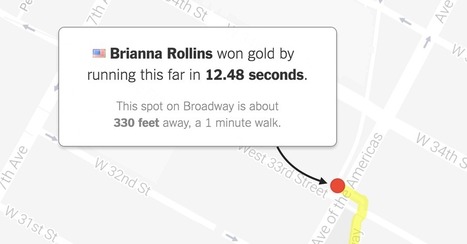
"What would Olympic races look like if they took place near you? Enter your address below to find out, or keep clicking the green button to explore races that begin in where you live."
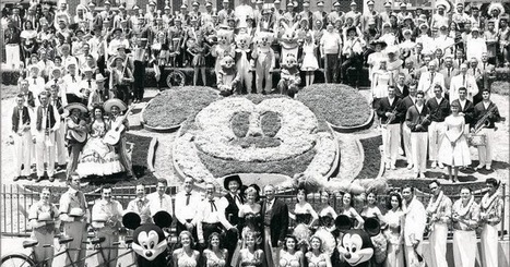
Today's History Lesson...theme park Via Sharla Shults

After years of teaching, speaking and publishing in an effort to convey the breadth and nuance of Africa’s thousands of cultural groups, earlier today, two weary professors gave up the fight to convince Americans that Africa is not, in fact, a country.
Skuuppilehdet's insight:
This was the best of the April Fool's Day articles. And no, will we never concede and we will fight on, because that's what teachers do.
Ivan Ius's curator insight,
April 3, 2016 11:57 AM
This was the best of the April Fool's Day articles. And no, will we never concede and we will fight on, because that's what teachers do. 
James Piccolino's curator insight,
March 24, 2018 10:26 AM
I may not have a large amount to say as far as analysis goes, I have to admit I'm glad to see some humor sprinkled in here in what is normally a sea of posts about sadness, economic depression and death.

A walkable map of the world, made from soil and stone by one man

Ian Fairhurst's curator insight,
November 26, 2015 4:02 PM
One for our Master Plan STEM Unit..... a walkable map of the Earth 
Maricarmen Husson's curator insight,
November 26, 2015 5:35 PM
Un mapa del mundo hecho con suelo y piedras.

The convergence of three state borders, or tri-points, offers a chance for out-of-the-way exploring.

We hear the names of these places in the news constantly, but can you actually locate them on a map? Via Mike Busarello's Digital Storybooks

Courtney Barrowman's curator insight,
August 24, 2015 2:10 PM
locational geography test your knowledge and challenge yourself!

"Revolution and rotation are the terms we use to describe the motions of the earth and moon. Revolution is the movement of the earth in an orbit around the sun. The Earth completes one revolution around the sun every 365 days. The moon revolves around the Earth about once every month." Via Mike Busarello's Digital Storybooks

Barbara Goebel's curator insight,
December 23, 2014 10:41 AM
Writing prompt: Specify a set of objects to put in motion, have them observe the interactions of the objects, then write to describe. For younger students, supply an observation organizer note sheet. For older students, the descriptions can be as technical as their math understanding will allow.
Jason Schneider's curator insight,
January 28, 2015 9:06 PM
It's pretty simple, the bigger the particle is, the bigger it's atmosphere is to allow more gravity. For example, Jupiter is the largest planet which is in favor to Earth. The reason why is because Jupiter uses it's large mass to protect Earth from oncoming meteors and comets. It uses it's large atmosphere to absorb comets and meteors onto Jupiter instead of allowing them to crash onto Earth. |