"The country is perhaps more aware of its own history than any other major society on earth. That remembering is certainly partial - events like Mao's Cultural Revolution are still very difficult to discuss within China itself. But it is striking how many echoes of the past can be found in its present."
This is a very interesting article...one can make too much of a country's history as a casual factors, and yet make too little of historical patterns at your own peril. "To understand China's approach today to trade, foreign policy or censorship, consider its history." This article considers a few of China's current policies that may seem peculiar today but that make much more sense with a longer and deeper history. Some of the topics considered include:
In this interesting article you can learn a lot about the Chinese history. The country is more aware of its own history than any other. major society on earth. some of the ways include:
In the 1860s and 70s, photographer Timothy O'Sullivan created some of the best-known images in American History. After covering the U.S. Civil War, (many of his photos appear in this earlier series), O'Sullivan joined a number of expeditions organized by the federal government to help document the new frontiers in the American West. The teams were composed of soldiers, scientists, artists, and photographers, and tasked with discovering the best ways to take advantage of the region's untapped natural resources. O'Sullivan brought an amazing eye and work ethic, composing photographs that evoked the vastness of the West. He also documented the Native American population as well as the pioneers who were already altering the landscape. Above all, O'Sullivan captured -- for the first time on film -- the natural beauty of the American West in a way that would later influence Ansel Adams and thousands more photographers to come.
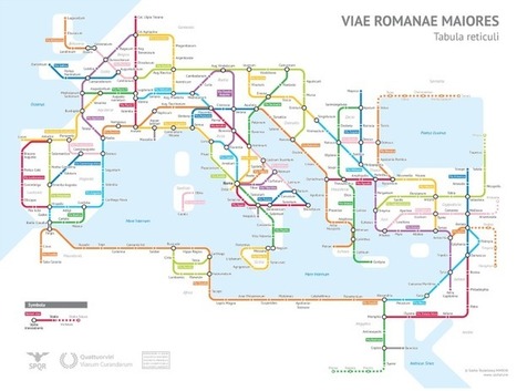
The map above is tube / subway style map of the major Roman roads around 125 AD. It is the amazing work of Sasha Trubetskoy and is largely based off the ORBIS model and The Pelagios Project.
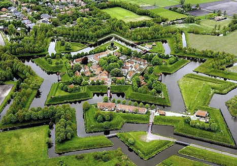
Fort Bourtange remains perfectly preserved, with historic structures strewn across the 11-acre pentagon.
Star forts, five-sided forts designed to give guards a panoramic view of any potential attackers, originated in Italy in the 15th century. Providing the optimal structure for protection from threats, star forts were used in Italian warfare for years and eventually diffused to the Groningen region of the Netherlands, where the Bourtange star fort was constructed in 1593.
The Star Forts, a five sided star carved into the ground surrounded by a swampy moat was the premier Defense system of the Late 1500's. These forts were designed to give guards a panoramic view of any attackers. Bourtange is the most fascinating and unique historical area and was originated in Italy in the 15th Century. Inside these forts are historical churches and wooden windmills with cobblestone streets. There are Beautiful bridges and old military barracks. The Forts were used in Italian warfare for years but they were eventually diffused to the Netherland region where Bourtange Star Fort was constructed.
"In February 1942, President Franklin Roosevelt issued Executive Order 9066, sending 120,000 people from the US west coast into internment camps because of their ethnic background. Two-thirds of them were born in America. The treatment of Japanese-Americans during the World War Two was denounced by President Ronald Reagan in 1988 as 'a policy motivated by racial prejudice, wartime hysteria, and a failure of political leadership.' He signed the Civil Liberties Act to compensate more than 100,000 people of Japanese descent who were incarcerated in internment camps."
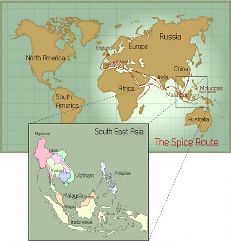
"In its day, the spice trade was the world’s biggest industry. It established and destroyed empires and helped the Europeans (who were looking for alternate routes to the east) map the globe through their discovery of new continents. What was once tightly controlled by the Arabs for centuries was now available throughout Europe with the establishment of the Ocean Spice Trade route connecting Europe directly to South Asia (India) and South East Asia."
A very insightful article and shows the uttermost importance of geography in many phases. First off, it shows the importance of having key resources within your country or region. Southeast Asia is know for its spices which made it especially key during the age of exploration. Also, which is key is how do we get there? What are the best trade routes? Over the years, first the Romans then the Ottoman Empire controlled key lands in which connected Europe and Southeast Asia. Since, the Christian Europeans did not want to work with the Muslims they found new trade routes and well eventually we end up discovering the New World (the Americas". This shows how everything like always connects. Southeast Asia, which for most of its time has been colonized up until almost the mid 1980s is finally starting to grow on its own. It will be interesting to see how they use there own resources to try to gain traction in the global markets throughout the next few decades and it we see any smaller world powers come out of the area. The spice trade dominated thousands of years of trade, but Southeast Asia has many other key resources as well and it will be key for politicians and businesses in the future to capitalize on this into the future.
It is no exaggeration to say that the spice trade shaped the world as we know it today. Southeast Asia's location made it the only place in the world to obtain some of the most popular spices and other goods. Meanwhile Constantinople, being situated squarely between Europe and Asia, was the perfect middleman through which spices could get to markets in Europe -- where demand was high from Antiquity through the Middle Ages -- until the city fell to the Ottoman Empire and turned its back on Europe. This motivated Europeans to develop the sailing and navigational technology necessary to find sea routes to Asia, which led to the discovery of the Americas, and the rest is history. What followed were centuries of colonization, conflict, trade, and globalization on a scale the world had never seen before. All because people were crazy for spices that could only be found half-way around the world.
The spice trade not only opened up all the amenities Southeast Asia had to offer but spread their culture throughout Western Europe. It also opened up new routes for Europeans to explore Eastern Asia and then sail around the world.
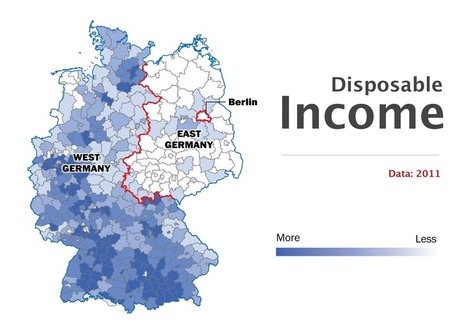
"While 75 percent of Germans who live in the east said that they considered their country's reunification a success, only half of western Germans agreed. With eastern and western Germans blaming each other for past mistakes over the past two years, that frustration has likely increased. Younger citizens, especially — who do not usually identify themselves with their area of origin as strongly anymore — have grown worried about the persistent skepticism on both sides. But where do those divisions come from? And how different are eastern and western Germany today?"
The social, political, and economic impacts of reunification are still being flt today. The old policies of both East and West Germany still impact the cultural and social habits of Germans. Despite the borders between the two former nations being eliminated almost 30 years ago, the differences between the two halves of Germany will be felt for decades to come. Issues from vaccines to child care to trash production all feel the effects of the policies of the former division.
From when this article was written it has been 26 years since Germany was completely unified. But over the last two years there has been a rift between east and west Germany. Economically the east feels left behind by the west with their rise of wealth. The west is mad that the east doesn’t taken in as many refugees as they do. These rifts between the two are not making things easy to work out between the two. All they are doing are pointing fingers and not coming up with solutions. Many people of the younger generations don’t feel as divided as the older generations do. They feel they are Germans and not east or west. Maybe they can find a way to bring people together as one.
You may think that since the fall of the Berlin wall that Germany has reunified itself and has become a strong nation again but that isnt such the case. The fact is that most of West Berlin still feel left out and feel that they are still shorted in the reunification.
"Without trying to defend or absolve U.S. policy, then, it is worth stepping back to ask what shared historical experiences might have left these four countries — Iraq, Syria, Libya and Yemen — particularly at risk of violent collapse. The following maps help highlight how, at various points over the past century, historical circumstances conspired, in an often self-reinforcing way, to bolster the stability of some states in the region while undermining that of others."
These maps are not cartographically inspiring, but the it's the historical and political insight that makes them valuable. The goal of this set of maps is to find some underlying causal reasons for political stability(or more importantly instability) in the Middle East. These four maps focus on these key issues:
From the western perspective, it's easier just to assume the Middle East is constantly in conflict purely out of their own fault. However, the story is more complicated than that and much of the conflict in the area is due to involvement from the west. These four maps show the different factors that impact the countries in the Middle East. The first one shows that countries that were fully formed states for longer, tend to be more stable. This makes sense because they haven't had outside influence for longer and have had more time to create stronger governments. Looking at just this map, it seems like Iran and Egypt should be more stable than Saudi Arabia today. However, this map doesn't tell the whole story. The second map shows the types of colonial rule that each country was under in recent history. Turkey was the only country in the region that was able to stay fully independent. Iraq, Libya, Syria, and Israel are some of the countries that were under full colonization. Not surprisingly, the struggles they had to gain their independence still effects the stability of these countries today. This shows that the involvement from outsiders has had negative, long-term effects on the area and that the west is not free from blame of what is happening in the Middle East. The third map differentiates between the countries that changed regimes after World War II and those that did not. There is a correlation between which countries experienced the change and the countries that are the least stable today. The final map shows which countries were pro-western, pro-Soviet, or shifted alignments during the Cold War. Once again the outside influence of both the west and in this case the Soviet Union, lead to further divide in the region. The history and shifting geography of the Middle East in just the last hundred years helps to give insight to how the region has become as conflicted in some countries, yet stable in others.
Long before Columbus reached the Americas, Cahokia was the biggest, most cosmopolitan city north of Mexico. Yet by 1350 it had been deserted by its native inhabitants the Mississippians – and no one is sure why
This article is the eighth in the "Lost Cities" series (Babylon, Troy, Pompeii, Angkor, Fordlandia, etc.). The earthen mounds of Cahokia on the flat flood plains must have been the most awe-inspiring demonstration of political power and economic wealth in its day. Like so many other civilizations before them (and many more in the future?), Cahokia probably declined from too many environmental modifications that led to unforeseen consequences.
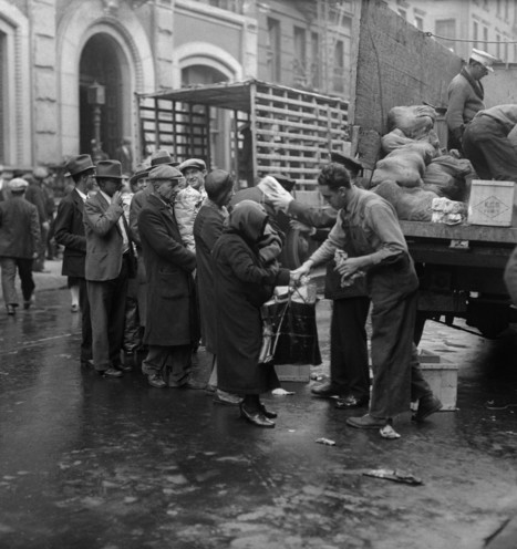
During the Depression, cheap, nutritious and filling food was prioritized — often at the expense of taste. Jane Ziegelman and Andy Coe, authors of A Square Meal, discuss food trends of the time.
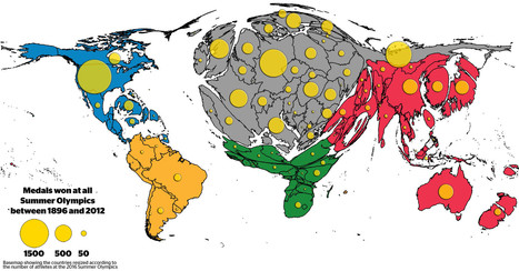
The distribution of medals shows the existing Olympic inequalities: The overall patterns are a reflection of wealth distribution in the world, raising the question whether money can buy sporting success. Besides investment in sports by those countries who can afford it, the medal tables also reflect a battle for global supremacy in political terms.
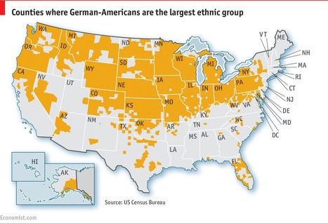
America’s largest ethnic group has assimilated so well that people barely notice it
German-Americans are America’s largest single ethnic group (if you divide Hispanics into Mexican-Americans, Cuban-Americans, etc). Yet despite their numbers, they are barely visible. During the first world war, parts of America grew hysterically anti-German. Many stopped speaking German and anglicized their names. The second world war saw less anti-German hysteria, but Hitler and the Holocaust gave German-Americans more reasons to hide their origins.
Tags: culture, migration, historical, ethnicity, USA.
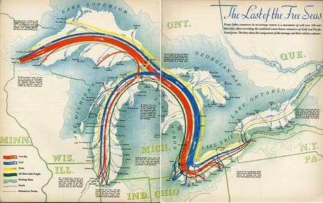
"The Last of the Free Seas is the title of this fantastic map of the Great Lakes made by Boris Artzbasheff. It was published in Fortune Magazine in July 1940."
"Simulating climate conditions over the last 125,000 years and predicting how those changes would have allowed humans to spread around the globe, this video models human migration patterns." Read more: http://ow.ly/lWIp304qZEo
Some interesting modelling based on climate change. I wonder what it would look like based on something different? Cultural differences? What came first culture or climate?
The World Economic Forum noted that some spatial research that was originally published in Nature, shows how geneticists took DNA samples from people of different cultures in different parts of the world to track their dispersal throughout the globe. The video uses climatic data, combined with the genetic data, to create a model showing how the human race spread across the globe over a 125,000 year period.
As the U.S. entered World War I, German culture was erased as the government promoted the unpopular war through anti-German propaganda. This backlash culminated in the lynching of a German immigrant.
"The [importance of this study is that it] examines the dynamic between geography and area studies through their distinct understandings of space. As I argue, the dominance of the regional concept in geography, which took the multiple ways of bounding space as its central problematic, was reduced in area studies rendering of global space. This study assesses the transformation of geography during the two decades before and after the Second World War. This era was one of contrasts. On the one hand, geography was central to the war effort and in the creation of post-war programs, most notably area studies. On the other, this era also marked the relative marginalization of geography as a discipline in higher education."
One specialized unit gathered data that could guide a missile to a target thousands of miles away.
The work of the 1370th bridged a crucial gap in the history of military technology. By the late 1950s, both the United States and the Soviet Union had developed intercontinental ballistic missiles, but satellite navigation systems like GPS weren’t yet up and running. That left military planners with a huge challenge: how to program a missile to hit a target on the other side of the world. Even a tiny mistake could be disastrous.
Why have I never heard of this? This is too interesting to have somehow just passed most of us by. The entire time I was reading this, I was hoping that they would offer an image of what the site looks like today, and luckily they did. As a history lover there has always been something so amazing about being able to compare historical sites in their prime vs what they are like now. I tend to look up locations of historic places after, say watching a tv show based there, for this same reason. To think this all was hidden under an old drive in movie theater, it's a little crazy, but then again that is what makes this sort of thing so interesting.
(North America) The common view of Native Americans involve nomads and small villages in the north and technologically advanced cities in Mexico. However, the largest Native American settlement was in modern day Illinois. At the time, Cahokia had a greater population than Paris or London and had huge intricate mounds, plazas, agricultural centers, and, most importantly, places of ritual worship. It's amazing how archaeologists can piece together so much of day to day life. Rooms with bones and pottery are discovered to be centuries old feasting rooms, a place with distinct pottery and mats is deemed to be a ritual burning ground. The fact that the workers can tell if objects were imported from other villages or how fast the city was built allows the ancient Americans to communicate with us over 600 hundred years later, especially on their religious beliefs of the Upper and Under Worlds. Not only are the archaeologists able to see daily life, they can see the changing history of the city through different housing patterns further below the soil.
It is a shame that probably not enough residents of the United States are aware that this wondrous city ever existed. People recognize the name "Manchu Picchu" but not Cahokia. Why is that the case in our American culture? The article reports that this city has been under serious excavation since the 1970s. Cahokia is a First Nations example of highly advanced civilization - something that even overtook medieval European civilization when the city was in its prime (1200 BCE). The hegemonic narrative of white, patriarchal supremacy - a view that is characterized as 'Eurocentric' - still dominates our culture and prevents stories like these from impacting and shaping how Americans view history. This is important because Cahokia is further evidence that no European ever introduced civilization to the First Nations. More accurately stated, Europeans introduced a different kind of civilization to the Indigenous Peoples implying a sense of equality and humanness. The resulting genocide of the First Nations by white Americans is even harder to justify and ignore because "savages" do not build magnificent cities based on complex systems of religion, spirituality, politics, and artistic expression.
For 50 years, high school students in Rabun County have chronicled their region's disappearing traditions and mountain people, from blacksmiths to moonshiners, in publications and a living museum.
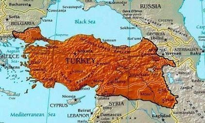
Erdogan’s aggressive nationalism is now spilling over Turkey’s borders, grabbing land in Greece and Iraq.
In the past few weeks, a conflict between Ankara and Baghdad over Turkey’s role in the liberation of Mosul has precipitated an alarming burst of Turkish irredentism. President Erdogan criticized the Treaty of Lausanne, which created the borders of modern Turkey, for leaving the country too small. Turkey won’t be annexing part of Iraq anytime soon, but this combination of irredentist cartography and rhetoric nonetheless offers some insight into Turkey’s current foreign and domestic policies and Ankara’s self-image. The military interventions and confrontational rhetoric this nationalism inspires may worsen Turkey’s security and regional standing.
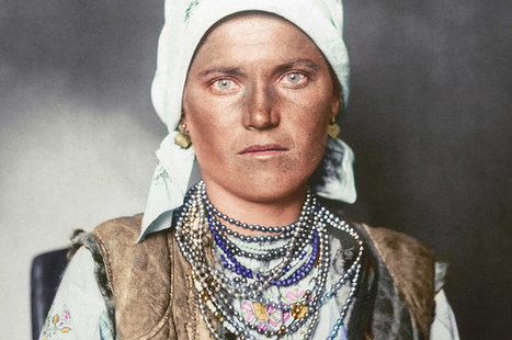
Here are just a handful of the 12 million men, women, and children who arrived at Ellis Island, New York, between 1892 and 1954 to start a new life in the USA, often dressed in their finest clothes. The portraits show immigrants wearing the national dress of their country of origin, including military uniforms from Albania, bonnets from the Netherlands, and clothing of Sámi people from the Arctic regions.
The photographs were taken between 1906 and 1914 by amateur photographer Augustus Francis Sherman, the chief registry clerk at Ellis Island, then the country’s busiest immigration station. In 1907 some of the photos were published by National Geographic.
Why do we dance? African-American social dances started as a way for enslaved Africans to keep cultural traditions alive and retain a sense of inner freedom. They remain an affirmation of identity and independence. In this electric demonstration, packed with live performances, choreographer, educator and TED Fellow Camille A. Brown explores what happens when communities let loose and express themselves by dancing together.
"Video and Photographs of the event. All media is from the internet and not my own. I compiled all media from the internet and edited them together to tell the story of the deadliest attack on America."
Because many students were not born when 9/11 occurred, or don't remember, it is important to have sources like this available. Take a moment and look at this information about this time in U.S. history.
I was only between 4 and 5 years old on September 11 2001. I admittedly do have trouble recalling that day. I seem to remember having my kindergarten class cancelled for that day as I was in the afternoon class, but I did not know why. By what my father has told me, many people thought the world was coming to an end. He told me his experience of that day when I was young but still long after the event, and he told me with a level of emotion that I never saw him speak with of anything else. What fear my father had, and the world had on that day, stuck with me after I had heard it. I do vaguely remember visiting the site somewhere around 2003 or 2004 I believe. What I saw was not the beautiful memorial site there is today, but a collection of chain link fencing and concrete. The fences were covered with memorials, flowers, pictures and papers. This video, accompanied with that sadly fitting piano rendition of Mad World, reminds me of what I almost was too young to know. This combined with the realization that as of this month there are adults who were born in the 2000's brings the realization that there are people who may not be able to "never forget" what they never knew. This is why it is important to always educate young people on the past, of dangers, of terrorism, and where they have brought us to now.
To get content containing either thought or leadership enter:
To get content containing both thought and leadership enter:
To get content containing the expression thought leadership enter:
You can enter several keywords and you can refine them whenever you want. Our suggestion engine uses more signals but entering a few keywords here will rapidly give you great content to curate.


 Your new post is loading...


This is a very interesting article...one can make too much of a country's history as a casual factors, and yet make too little of historical patterns at your own peril. "To understand China's approach today to trade, foreign policy or censorship, consider its history." This article considers a few of China's current policies that may seem peculiar today but that make much more sense with a longer and deeper history. Some of the topics considered include:
Tags: China, East Asia, historical.