Human Interest
198.8K views | +0 today
Follow
Human Interest
Your new post is loading...
Scooped by Skuuppilehdet
Scoop.it!

The American West, 150 Years Ago

The American West, 150 Years Ago | Human Interest | Scoop.it
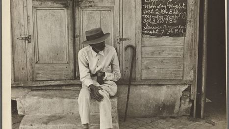
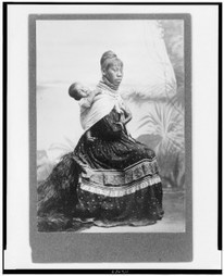
In the 1860s and 70s, photographer Timothy O'Sullivan created some of the best-known images in American History. After covering the U.S. Civil War, (many of his photos appear in this earlier series), O'Sullivan joined a number of expeditions organized by the federal government to help document the new frontiers in the American West. The teams were composed of soldiers, scientists, artists, and photographers, and tasked with discovering the best ways to take advantage of the region's untapped natural resources. O'Sullivan brought an amazing eye and work ethic, composing photographs that evoked the vastness of the West. He also documented the Native American population as well as the pioneers who were already altering the landscape. Above all, O'Sullivan captured -- for the first time on film -- the natural beauty of the American West in a way that would later influence Ansel Adams and thousands more photographers to come.


Tags: images, artlandscape, tourism, historicalUSA.

Rescooped by Skuuppilehdet from U.S HISTORY SHACK : MIKE BUSARELLO
Scoop.it!

The New York Public Library just uploaded nearly 200,000 images you can use for free

The New York Public Library just uploaded nearly 200,000 images you can use for free | Human Interest | Scoop.it
The New York Public Library just released a treasure trove of digitized public domain images, everything from epic poetry from the 11th century to photographs of used car lots in Columbus, Ohio from the 1930s. Over 180,000 manuscripts, maps, photographs, sheet music, lithographs, postcards, and other images were released online Wednesday in incredibly high resolution, and are available to download using the library's user-friendly visualization tool. It's a nostalgist's dream come true.
Via Mike Busarello's Digital Storybooks
Margarita Saucedo's curator insight, February 6, 2017 11:39 AM
Cuando se anda en búsqueda de buenas imágenes
Mike McCallister's curator insight, February 6, 2017 4:20 PM

Blogs and social media posts are always enhanced by graphics. More people look at and interact with posts with photos. Here's another place to find compelling graphics.

ROCAFORT's curator insight, February 7, 2017 2:48 PM
The New York Public Library just uploaded nearly 200,000 images you can use for free
Scooped by Skuuppilehdet
Scoop.it!

The Environmental Cost of Consumption

The Environmental Cost of Consumption | Human Interest | Scoop.it
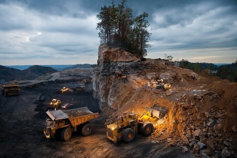
Environmental artist J Henry Fair captures the beauty and destruction of industrial sites to illustrate the hidden impacts of the things we buy – the polluted air, destroyed habitats and the invisible carbon heating the planet
Sally Egan's curator insight, October 30, 2016 6:28 PM
Photographic essay illustrates the impacts of human use of resources. The beautiful images illustrate the extreme impact on the environment.
Sally Egan's curator insight, October 30, 2016 6:30 PM
Photographic essay illustrates the impact of human activity on environments.
GTANSW & ACT's curator insight, November 16, 2016 5:37 PM

Production and consumption - interconnections and consequences 

Scooped by Skuuppilehdet
Scoop.it!

Brexit: Reaction and the Aftermath

Brexit: Reaction and the Aftermath | Human Interest | Scoop.it

"The reactions to the Brexit have come in from all corners.  Since this was so shocking, newspapers articles that are insightful are using hyperbole in their titles to get our attention (Britain just killed globalization as we know it–Washington Post; Will Brexit mark the end of the age of globalization?–LA Times).  There have also been some excellent political cartoons and memes, so I wanted to archive a few of them here."  


Tags: Europe, supranationalism, globalization, economic, political, images.

MsPerry's curator insight, June 29, 2016 11:29 AM
Share your insight
Taylor Doonan's curator insight, February 16, 2018 8:40 AM
These graphics are examples of propaganda, which has been used for hundreds of years. Great Britain leaving the EU was a big deal as it was basically GB saying that they were better than the rest of Europe. These graphics show what different sources around the world thought of Brexit. The one that stood out to me was the picture of the woman who appeared beaten up and the captions stated that it was the EU with and without GB, and this shows that GBs influence is not nearly what it used to be and that Europe can survive without it. 
Rescooped by Skuuppilehdet from HOMEHISTORY
Scoop.it!

Can You Guess Where You Are in 60 Seconds?

Can You Guess Where You Are in 60 Seconds? | Human Interest | Scoop.it
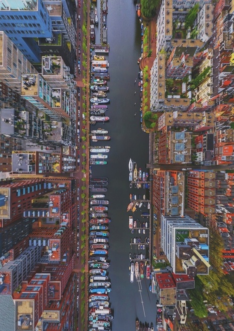
Can you guess where we are taking you today? Here's a clue: This city's name translates to "where the river narrows."

Via Ben Salve
No comment yet.
Scooped by Skuuppilehdet
Scoop.it!

The World’s Driest Desert Is in Breathtaking Bloom

The World’s Driest Desert Is in Breathtaking Bloom | Human Interest | Scoop.it

"After historic rains, Atacama, Chile is exploding with vibrant wildflowers.  Here's a softer side to the disruptive weather phenomenon known as El Nino: an enormous blanket of colorful flowers has carpeted Chile's Atacama desert, the most arid in the world. The cyclical warming of the central Pacific may be causing droughts and floods in various parts of the world, but in the vast desert of northern Chile it has also caused a vibrant explosion of thousands of species of flowers with an intensity not seen in decades."

Olivia Campanella's curator insight, September 26, 2018 10:42 AM
This article is about a desert located north of Chile where a barren desert becomes a valley of pink wildflowers. This desert acts like a high pressured trap keeping the low pressure storm out and leaving most parts of the landscape parched with less than 0.2 inches of rain. earlier that year, unexpected clouds started forming leaving the barren land with 2 inches of snow and rain. Enough had fallen to cause an overflow of the banks and rivers to create flooding. But, even though this rain caused flooding it brought the valley "back to life" leaving a seemingly endless carpet of pink wildflowers.
Matt Danielson's curator insight, September 29, 2018 4:59 PM
The Atacama desert is the nearly never receives rainfall. Every decade or so it does get some rain. When this happens the buried seeds that await the rains germinate and blossom causing a vast landscape of beautiful purple and pink flowers in a normally arid desert.  This phenomenon happen recently causing the greatest bloom seen in the Atacama desert in decades. This if anything proves the beauty and resilience of nature, even with nearly no rain in a desert plants still find a way to overcome. 
Kelvis Hernandez's curator insight, September 29, 2018 10:00 PM
Truly amazing. After an intense rainfall, the Atacama desert in Chile was in bloom. The Atacama desert which has been described as the driest place in the world was hit with 2 inches of rain that caused massive flooding throughout the area. While the floods moved the desert and created something beautiful, you can not ignore the fact that they also moved through cities causing some deaths and a billion dollars in damages. Nature can be both beautiful and terrifying.
 
Rescooped by Skuuppilehdet from Stage 4 Landforms & Landscapes
Scoop.it!

The Dramatic Landscape of China's Gansu Province

The Dramatic Landscape of China's Gansu Province | Human Interest | Scoop.it
Gansu Province, in northwestern China, is about the same size as California, with a population of about 26 million people. Gansu’s diverse landscapes include parts of the Gobi Desert, the Yellow River, numerous mountain formations, and remnants of the Silk Road and the Great Wall of China.

Via GTANSW & ACT
Tony Hall's curator insight, October 30, 2015 2:34 AM

Some truly amazing images in this collection from The Atlantic.

Scooped by Skuuppilehdet
Scoop.it!

How People Around the World Take Exams

How People Around the World Take Exams | Human Interest | Scoop.it

"Examinations, tests, assessments—whatever the nomenclature, it’s hard to imagine schooling without them. Testing is the most popular method of quantifying individuals’ knowledge, often with the intention of objectively measuring aptitude and ability. Test-taking is a dreaded experience that the country’s kids and young adults share with their counterparts across the globe. The ritual at its core doesn’t vary much: Students sit at a table or a computer desk (or sometimes, as shown below, on the floor), pencil and/or mouse in hand, the clock ticking away mercilessly."

Courtney Barrowman's curator insight, November 7, 2015 9:58 AM

unit 3

Courtney Barrowman's curator insight, November 7, 2015 9:59 AM

unit 3

careerpath12's curator insight, March 11, 2016 1:10 AM

I am torn on how to teach these two ideas about cultures and societies all around the world:

People and cultures are different all over the world.People and cultures are the same all over the world.

Cultural practices are often so similar, are done in slight different fashion.  This photo gallery can create opportunities for our students to 'see' themselves in other cultures while at the same time seeing the richness of global cultural practices. 


Tags: education, K12, worldwide.

Rescooped by Skuuppilehdet from AP HUMAN GEOGRAPHY DIGITAL STUDY: MIKE BUSARELLO
Scoop.it!

The Orange Globe

The Orange Globe | Human Interest | Scoop.it
Creative Clever Objects by Martin Roler

Via Mike Busarello's Digital Storybooks
No comment yet.
Scooped by Skuuppilehdet
Scoop.it!

Topaz Solar Farm, California

Topaz Solar Farm, California | Human Interest | Scoop.it
The new 550 megawatt facility in California produces enough electricity to power 180,000 homes.


The modules are part of Topaz Solar Farm, one of the largest photovoltaic power plants in the world. At 9.5 square miles (25.6 square kilometers), the facility is about one-third the size of Manhattan island, or the equivalent of 4,600 football fields.

Construction at Topaz began in 2011. The plant was mostly complete by November 2014, when it was turned on and began to generate electricity.


Tagsenergy, resources, unit 6 industry, California, images, remote sensing.

Maricarmen Husson's curator insight, March 24, 2015 4:01 PM

GRANJA SOLAR TOPAZIO EN CALIFORNIA. PROVEE ELECTRICIDAD A 180.000 HOGARES. PLANTA DE ENERGÍA SOLAR


María del Sol Guerra martín's curator insight, April 4, 2015 7:23 AM

In this text you will find information about a photovoltaic power  plant. Could you find information about photovoltaic plants in Spain?
Send the report before ....

Aleena Reyes's curator insight, April 8, 2015 7:20 PM

Seeing America taking steps in use solar power makes me incredibly happy. The US, in my opinion, needs to adopt multiple ways of utlizing various types of energy sources. The quote, "BHE estimates, that is enough to displace about 407,000 metric tons of carbon dioxide per year, the equivalent of taking 77,000 cars off the road" is impressive. However, I do feel that the auto industry is the environmental scape goat. The textile industry produces much more waste, especially with all of the advancements the auto industry has gone through.

Scooped by Skuuppilehdet
Scoop.it!

Human Landscapes of Canada

Human Landscapes of Canada | Human Interest | Scoop.it
Canada is a massive country, yet it has one of the lowest population densities in the world. Despite this, Canadians have made a wide impact on their land, much of it visible from aerial and satellite photography. Hydroelectric facilities, roads, mines, farms, ports, resource exploration, logging, canals, cities, and towns have altered much of the landscape over the years.
Bharat Employment's curator insight, February 23, 2015 1:02 AM
http://www.bharatemployment.com/
Vincent Lahondère's curator insight, March 8, 2015 11:20 AM

Un vrai plaisir

Michael Amberg's curator insight, May 26, 2015 11:28 PM

This shows how even small populations can make a big impact on the world from the changes in urbanization.

Rescooped by Skuuppilehdet from HMHS History
Scoop.it!

Human Development Index (HDI)

Human Development Index (HDI) | Human Interest | Scoop.it

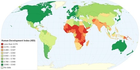
"This map shows Human Development Index (HDI) for 169 countries in the World. The HDI is a comparative measure of life expectancy, literacy, education, and standard of living for countries worldwide. The HDI sets a minimum and a maximum for each dimension, called goalposts, and then shows where each country stands in relation to these goalposts, expressed as a value between 0 and 1, where greater is better. The Human Development Index (HDI) measures the average achievements in a country in three basic dimensions of human development: health, knowledge and standard of living."


Tags: development, statistics, worldwide.


Via Michael Miller
Caroline Ivy's curator insight, May 18, 2015 10:41 AM

This article discusses the Human Development Index (HDI), what it is, and how it is calculated. 


This chart displays that the top three spots on the HDI are occupied by Norway, Australia, and the Netherlands respectively, with the USA coming in fourth. As HDI is calculated by comparing aspects like literacy, standard of living, education, and life expectancy, why are two European countries and Australia in the top 3? Something to be looked at is the in-migration of each country. Immigrants arrival in large numbers in some countries can lower HDI if they are refugees or come from a country with a lower HDI, for they may be illiterate, have a low education, and therefore a low life expectancy. With in migration to the US tightly controlled but in constant motion, their HDI could be pulled down to 4th. As Norway and Australia and the Netherlands are not the main destination for refugees, their HDI could be higher.   

Cody Price's curator insight, May 27, 2015 12:49 AM

The HDI is the human development index which ranks countries in many different aspects. The higher the country the more developed and modern it is. The least amount of death and the longest lives are here. It is more stable the higher the country.


This relates to the topic in unit 6 of HDI. this map shows the basic HDIS of the world and the patterns formed by the HDI layout of the world. 

Anna Sasaki's curator insight, May 27, 2015 2:04 AM

This map shows the Human Development Index around the world. The HDI depends on a set list of variables, ranking them from 1st to last. Nations considered to be "Western" are more developed than nations in regions such as Africa and Asia, although all nations are slowly but steadily developing, improving their Human Development Index ranking.

The HDI shows development in nations, although leaving out Inequality factors. This map also allows us to see spatially what regions tend to be more developed as well as developing.

Rescooped by Skuuppilehdet from U.S HISTORY SHACK : MIKE BUSARELLO
Scoop.it!

Brazil and Europe

Brazil and Europe | Human Interest | Scoop.it

Via Mike Busarello's Digital Storybooks
Gene Gagne's curator insight, November 20, 2015 7:59 PM

I would say. Just imagine three mega cities like Rio de Janeiro, population 11,960,000 then Buenos Aires with a population of 13,530,000 and finally Sao Paulo with the Southern Hemisphere's largest metropolitan area with a population of 19,920,000 with 2 more Mega cities to be added by 2025.

Kevin Nguyen's curator insight, November 24, 2015 11:52 AM

I cannot believed the size of Brazil is at this scale because we don't hear a lot about it as being a world power. It shows that even though the country is this big, most of the land is uninhabitable due to the forests and geography of the land. In addition, from history class one cannot imagine a small country like Portugal controlled a big country as Brazil from the colonial times. Seeing this map with all these European countries inside of it with some space leftover, one can see the massive size of this South American country.

Adam Deneault's curator insight, December 7, 2015 12:47 PM
This link to show me a picture of Europe fitting in Brazil is astounding! I never realized how large this country was until it was put together like a puzzle for me. For a single country to be that large that you would be able to fit an entire continent inside is absurd. That really goes to show that looks can be deceiving.
Scooped by Skuuppilehdet
Scoop.it!

25 Photos That Will Make You Fall in Love With Norway

25 Photos That Will Make You Fall in Love With Norway | Human Interest | Scoop.it

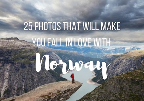
"So how gorgeous is Norway? From its majestic wildlife, captivating Northern Lights shows, and snowy mountains, to its vivid landscapes, and mystifying fjords, Norway is a must-visit destination for anyone who loves the outdoors. Plus, opportunities for hiking, kayaking, glacier climbing, fishing, and skiing are endless! If Noway wasn’t already on your travel bucket list, I bet it is now!"

Deanna Wiist's curator insight, September 12, 2017 8:59 PM

My wife lived in Norway for 18 months, and her love for this country is infectious.  The stunning physical geography leads to some equally magnificent cultural landscapes that were forged in a very rugged, inhospitable environment for early human settlers.   


Tags: Norway, place, tourismphysical, Arctic, geo-inspiration, images, artlandscape.

Rescooped by Skuuppilehdet from Navigate
Scoop.it!

100 Great Teaching Images

100 Great Teaching Images | Human Interest | Scoop.it

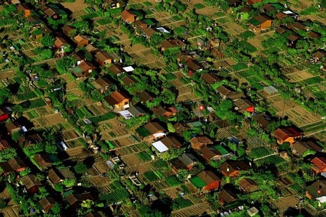
"Nature and humankind are both great artists, and when they join forces, amazing masterpieces can be produced. Today Bright Side has collected for you works in which the combined efforts of mother nature and photographic artists have captured magic moments showing the wondrous diversity of modern life and the natural world. Pictured above is the Westerdok District in Amsterdam."


Tags: images, art, landscape, worldwide.


Via Suvi Salo
Sue Alexander's curator insight, December 27, 2016 10:04 AM
AAAAAAmazing!
Willem Kuypers's curator insight, December 28, 2016 2:05 AM
De très belle photos à utiliser dans les présentations.
Mireia Civís Zaragoza's curator insight, December 29, 2016 9:36 AM
fotos espectaculars
Rescooped by Skuuppilehdet from AP HUMAN GEOGRAPHY DIGITAL STUDY: MIKE BUSARELLO
Scoop.it!

Aerial Photos Show how Apartheid Still Shapes South African Cities

Aerial Photos Show how Apartheid Still Shapes South African Cities | Human Interest | Scoop.it
An American used drones to capture the color lines still stark in South African cities.

Via Mike Busarello's Digital Storybooks
Richard Aitchison's curator insight, March 9, 2018 10:13 AM
"I agree with you, I think that the images are chilling. And they communicate so well what is otherwise a very complicated and nuanced issue to discuss—separation, segregation, history, disenfranchisement. But the images cut right to the heart of the matter, which is that these separations are not right" This is a quote in the article from the man that took the pictures (Johnny Miller). These photos show us the lines of segregation that continues even in a post Apartheid South Africa. These are amazing images and really quite unbelievable. We think of different segregation here in America, but what these photos show are unlike anything that I have personally seen.  As stated in the article the author hopes to create conversations about these separations. We see planned spatial separations that we created by city planners and we must used these as lessons going forward and as jumping off points to discuss. These shocking images can help inform us as a society that we must improve our social issues and if we don't we will continue to see issues like this grow both here in South Africa and around the world. One can see while tensions would be so high as a clear divide in living standards can rightfully cause anger. Eventually this anger leads to hate and this hate leads to an up rise in the people. 
Katie Kershaw's curator insight, March 31, 2018 4:23 PM
South Africa is one of the few countries that has a similar history in regards to racial segregation as America.  What makes their case unique is that the African population was there first and the English came in and created a system in which they were superior.  Although they have been officially desegregated for almost 20 years, these photos show that there are still underlying issues that exist.  These photos reveal that on one side of a particular area, the homes look like a typical suburban area where right across from that there are areas that resemble slums.  The areas that are more developed and wealthy have a majority white population and the poorer, less developed areas have large black populations.  The affects of segregation are long lasting and not solved overnight.  Just because government policies say that discrimination on a racial basis is illegal, doesn’t mean that society will neatly reorganize itself.  I think that the craziest part of this for me was that even the landscaping is vastly different despite the closeness of the two areas.  The wealthier part has lush green and the poorer parts have dirt and sand.  This an example of physical geography providing evidence for a societal separation.
David Stiger's curator insight, November 10, 2018 6:22 PM
Just because a formal social construct - an idea in the human mind - changes, does not mean that change, or desire to alter course, is reflected in the real world. While the idea of apartheid in South Africa came to an end, the real world in the form of urban geography has yet to catch up. The urban planning under apartheid still carries the legacy of color codes and demarcated boundaries between "races" in order to cement socioeconomic inequity. This situation in South Africa is similar to the United States after the Civil Rights movement ended the era of Jim Crow. Even though laws were passed, the geography remained largely untouched. Black neighborhoods remained socially and economically segregated - the only difference being that the law did not mandate this. The law never stipulated geographic changes or economic prescriptions like wealth redistribution. It turns out that human geography and philosophical principles can be at odds with each other, as demonstrated by the aerial photographs of South African cities. 
Scooped by Skuuppilehdet
Scoop.it!

Aerial Photos of Iceland Volcanic Rivers

Aerial Photos of Iceland Volcanic Rivers | Human Interest | Scoop.it

On occasion, we are reminded of how utterly captivating and gorgeous nature is, its visual poetry surrounds us. It just takes a step back, a shift in perspective, to realize how amazing the constructs of this planet are; it’s a beautiful constant balance between order and entropy. Case in point, what appears to be well-crafted, intricate abstract paintings, or works of art, are in reality, mindblowing aerial images of Iceland."

Joaquín del Val's curator insight, May 27, 2016 1:20 PM
Espectaculares imágenes de canales fluviales en Islandia
Scooped by Skuuppilehdet
Scoop.it!

Photographing mega-cities from 12,000 feet

Photographing mega-cities from 12,000 feet | Human Interest | Scoop.it
Photographer Vincent Laforet spent the early stages of 2015 photographing the likes of New York, Las Vegas, London, Sydney and Barcelona from a helicopter.


Tags: urban, megacities, unit 7 cities, images.

No comment yet.
Scooped by Skuuppilehdet
Scoop.it!

Images of Native Americans: Exploring Changing Visual Representations

Images of Native Americans: Exploring  Changing Visual Representations | Human Interest | Scoop.it
One benefit of my job at the Library of Congress is that I get to learn some history and read critical analysis while also locating resources and finding ways to support teachers in the classroom.
No comment yet.
Scooped by Skuuppilehdet
Scoop.it!

The World’s Largest Urban Area Grew Overnight

The World’s Largest Urban Area Grew Overnight | Human Interest | Scoop.it
Rapid growth in several cities along the Pearl River Delta has made a Chinese megacity larger and more populous than any other urban area in the world.
Tanya Townsend's curator insight, November 16, 2015 8:50 PM

Already this image is showing a clear impact that the massive increase in population is having on the landscape. The delata has narrowed and so has the major rivers. As population grows in mega cities like this so doesnt the increase for resources such as water, also when it increases this quickly sanitation practices decrease. One can only imagine the inpact on water quality this is also having.

Benjamin Jackson's curator insight, December 13, 2015 7:46 AM

It is amazing how fast a modern city can come about when there is no historical city to base the subsequent growth on.

Nicholas A. Whitmore's curator insight, December 16, 2015 3:39 PM

It is astounding the amount of growth this one city has had in one decade and reminds me of some of the rapid development within the Middle East since the 70s which transformed cities like Dubai. Ecologically like most of what China does it is a disaster but fascinating from a development  one. Unfortunately the article doesn't offer a population so that it could be compared to Tokyo's since a size comparison was done in terms of land use. Hopefully China will find a sustainable method of growth because if city continue to grow like this it will be surprising if they could maintain stability. I personally thing this rapid growth is dangerous and like India they likely won't be able to keep up. Additionally since China's economy is very reliant on this type of growth it is concerning to think of what may happen to many of these cities when the growth they rely on stops.

Rescooped by Skuuppilehdet from AP HUMAN GEOGRAPHY DIGITAL STUDY: MIKE BUSARELLO
Scoop.it!

Even When You Go Off the Grid, You Might Still Be On It

Even When You Go Off the Grid, You Might Still Be On It | Human Interest | Scoop.it

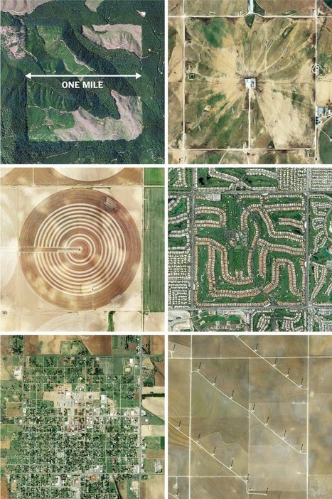
"The images here, taken from the Instagram account @the.jefferson.grid show just a few of the landscapes that can be squeezed into the one-mile squares. The idea behind this sprawling checkerboard emerged after the Revolutionary War. As the United States expanded westward, the country needed a systematic way to divide its newly acquired lands. The original colonies were surveyed using the British system of 'metes and bounds,' with parcels delineated using local geography.  


That approach doesn’t scale very well, and Jefferson proposed to slice the young United States into gridded plots of land.  Jefferson's idea became a reality in 1785 when it was enacted as the Public Land Survey System. Today his grid covers much of the country, and it is still used to survey federal lands — an idea that shaped the physical landscape of half a continent."


Tags: images, land use, landscape, social media, planning, spatial, scale, historical.


Via Mike Busarello's Digital Storybooks
Dyna-e International's curator insight, September 1, 2015 12:32 PM

No such thing as being off the grid really.  ~ Ron Sandack

Courtney Barrowman's curator insight, September 8, 2015 1:05 PM

unit 1 and 4

Scooped by Skuuppilehdet
Scoop.it!

22+ International Borders Around The World

22+ International Borders Around The World | Human Interest | Scoop.it
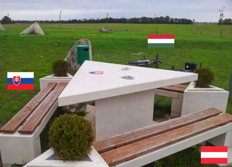
History (and sometimes, unfortunately, current events) shows us just how easily national borders can change, but we still like to think that they are permanent fixtures. These photos of different national borders around the world show you how both friendly and hostile nations like to fence off their turf.
Courtney Barrowman's curator insight, June 1, 2015 9:38 AM

Unit 4

Dwane Burke's curator insight, June 3, 2015 6:16 PM

What do these say about the world?

Rescooped by Skuuppilehdet from AP HumanGeo
Scoop.it!

Urban Agriculture

Urban Agriculture | Human Interest | Scoop.it

"Aerial photo tour across countries and continents with a French photographer Yann Arthus-Bertrand"


Via Dawn Haas Tache
Kaitlin Young's curator insight, September 17, 2014 12:10 PM

In a time where more people are moving away from their rural roots to try and make it big in the city, I think it's becoming more and more important that we focus on how to utilize our urban surroundings in a beneficial way. These photos are proof that it is possible, and I believe that cities in the United States should be more open to urban farming. It could be a way to not only take pressure off of families in cities trying to feed their children, but will also educate all sorts of people on where food comes from, and the importance of the environment. 

Maria la del Varrio's curator insight, December 13, 2014 3:16 PM

Urban agriculture is a reality in third world countries. In Dominican Republic almost everyone in the country side have its own land to plant necessary food and fruits. The most popular is plantain and fruit is orange.

In urban areas is rare to see this, so is surprising to see how central Asians are doing it.

BrianCaldwell7's curator insight, March 16, 2016 3:58 PM

I love Yann Arthus-Bertrand's photography; so many of them are geography lessons in and of themselves as he captures compelling images of the cultural landscape.  This particular gallery shows 32 stunning images including this one above showing urban agriculture in Geneva, Switzerland.    


"Worldwide, there are 800 million amateur farmers in built-up areas. In estates in south eastern Asia and some towns in central and South America, many people depend on this activity for survival. It’s the same story in Europe; in Berlin there are more than 80,000 urban farmers, and in Russia more than 72% of all urban homes till their own patch of land, balcony or even roof. Urban agriculture is on the [rise] and there could be twice as many people enjoying it within twenty years."


Tags: agriculture, foodlandscape, images, urban, unit 5 agriculture, unit 7 cities. 

Scooped by Skuuppilehdet
Scoop.it!

Endangered Wildlife Trust

Endangered Wildlife Trust | Human Interest | Scoop.it

"If you don't pick it up they will."

No comment yet.
Scooped by Skuuppilehdet
Scoop.it!

Dramatic Confluences

Dramatic Confluences | Human Interest | Scoop.it

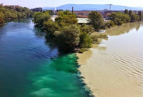
"Confluences occur wherever two streams come together. If the gradient is low (i.e., nearly level) and the properties of the two streams are very different, the confluences may be characterized by a dramatic visible distinction as the mixing occurs only slowly."


Tagsphysical, fluvial, geomorphology, erosion, landscape.

Sylvain Rotillon's curator insight, January 7, 2015 5:47 AM

Wonderful pictures of rivers confluences