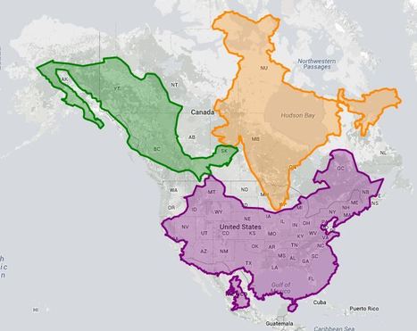
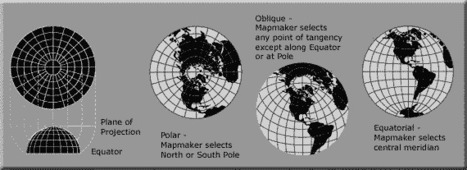
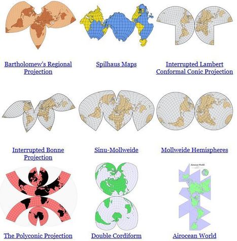
"As you may know, Google Maps uses the Mercator projection. So do other Web mapping services, such as Bing Maps and MapQuest. Over the years I’ve encountered antipathy toward the use of the Web Mercator from map projection people. I know of two distinct schools of opposition. One school, consisting of cartographic folks and map aficionados, thinks the Mercator projection is 'bad': The projection misrepresents relative sizes across the globe and cannot even show the poles, they are so inflated. The other school, consisting of geodesy folks, thinks mapping services have corrupted the Mercator projection, whether by using the wrong formulæ for it or by using the wrong coordinate system for it."
Get Started for FREE
Sign up with Facebook Sign up with X
I don't have a Facebook or a X account
 Your new post is loading... Your new post is loading...
 Your new post is loading... Your new post is loading...
Carlee Allen's curator insight,
March 26, 2015 6:58 PM
This article explains and talks about 18 specific map projections. It gives a lot of detail about all of them, and describes the disadvantages and uses for all of them.
I thought that this was interesting because I learned more about map projections, and actually how people use them. 
Leah Hood's curator insight,
August 22, 2017 5:02 PM
This article chronicles 18 map projections, how they are mathematically rendered with their own unique set of advantages and disadvantages. Questions to Ponder: Why do map projections matter? Is one global map projection inherently better than the rest? What is your favorite? Tags: Mapping, visualization, map projections, cartography, perspective. |

Alex Smiga's curator insight,
September 7, 2015 4:23 PM
Seth Dixon's insight:
No screenshot could do justice to this animation. It transforms a map of the world from one map projection to another, and in the 5 second interval it 'spins the globe' to give you a sense of the the spatial distortions inherent in all projections. This is but one of the many visualizations fromJason Davies mapping project. 
Vincent Lahondère's curator insight,
January 4, 2018 5:42 PM
Un site qui permet de visualiser les principales projections cartographiques

Zavier Lineberger's curator insight,
March 15, 2018 3:42 PM
(Russia) In a world of globalization, this considered highway could make the world a little smaller. The Trans-Eurasian Belt Development project intends to create a road alongside the Trans-Siberian Railway, crossing all of Russia to link with roads spanning throughout Europe and connecting to North America through Alaska. The head of Russian Railways did not explain how the road would cross the Bering Strait. There are 55 miles between Russia and Alaska at the narrowest point, and one consecutive bridge would still be half the length of the longest bridge in the world. It is definitely doable. Linking to roads in Alaska and across the continent, a trip from London to New York could be about 12,910 miles, all by car. The road network would apparently pay for itself with weighty economic promise, however Russian Railways provided no information on this financial promise. The highway would connect most of the world, but tense relations between Russia and the US and Europe could hinder progress. Additionally, the road would cost trillions of dollars, take a very long time, and require frequent maintenance, especially across seldom traveled regions in Siberia.
brielle blais's curator insight,
March 29, 2018 5:20 PM
This showcases how the geography of the world can be linked together to grow the economic stability of each country through easier access to products and goods. By creating the trans-siberean highway, Russia would be connected to the United States by their western coast. This allows access for places once very difficult to travel too.

Kelvis Hernandez's curator insight,
November 1, 2018 11:05 AM
The Russian Railway president has proposed a plan for a Europe to U.S. superhighway. The Trans'Eurasian Belt Development would lead London to Moscow through Siberia, over the Bering Strait to Alaska, through Canada ending in New York. This would take major coordination between all the different countries. You must think about the time, money and effort this would take. From Eastern Russia to Alaska, how would drivers get over the gap? Who would tear through the forests and stretches of land needed to create this?

Rich Schultz's curator insight,
February 11, 2015 11:27 AM
Would an inverted Peters projection "freak you out"? 
Tiani Page's curator insight,
April 27, 2015 11:51 PM
As part of geography education we are required to teach students about different map projections and the rationale for these. This little video puts it quite well. 
Adelaide Parkin's comment,
September 7, 2016 8:52 PM
This is an engaging and funny clip! It is a great resource that could be used in a lessons introduction! for myself i love finding funny little clips that relate to a topic to play at the start of a lesson and then explain to the students what the topic is! Great resource i will be saving for later
|


Mercaror ArcGis