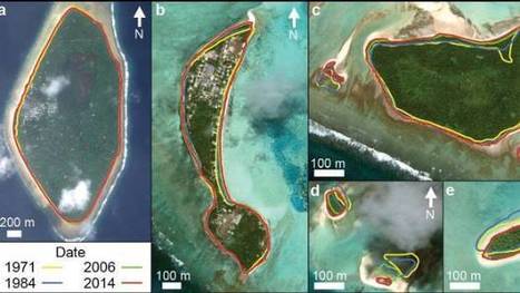
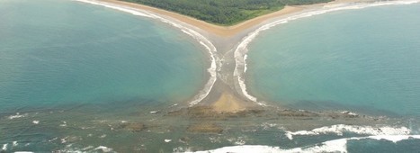
"The tiny Pacific nation of Tuvalu – once thought to be under threat from rising sea levels – has grown the size of California's Disneyland over the past 40 years. It's mostly thanks to waves dumping extra sediment, sand and gravel on shore lines, according to research by Auckland University scientists. The study, published in the Nature Communications journal on Friday, was the first in-depth look at how much each of Tuvalu's 101 islands have changed over the decades."
In the 1860s and 70s, photographer Timothy O'Sullivan created some of the best-known images in American History. After covering the U.S. Civil War, (many of his photos appear in this earlier series), O'Sullivan joined a number of expeditions organized by the federal government to help document the new frontiers in the American West. The teams were composed of soldiers, scientists, artists, and photographers, and tasked with discovering the best ways to take advantage of the region's untapped natural resources. O'Sullivan brought an amazing eye and work ethic, composing photographs that evoked the vastness of the West. He also documented the Native American population as well as the pioneers who were already altering the landscape. Above all, O'Sullivan captured -- for the first time on film -- the natural beauty of the American West in a way that would later influence Ansel Adams and thousands more photographers to come.
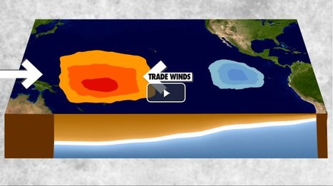
"El Niño and La Niña are complex weather patterns resulting from variations in ocean temperatures in the Equatorial Pacific--officially known as the El Niño-Southern Oscillation (ENSO) cycle. These deviations from normal surface temperatures can have large-scale impacts not only on ocean processes, but also on global weather and climate."
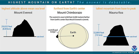
"Mount Everest is usually said to be the highest mountain on Earth. Reaching 29,035 feet at its summit, Everest is indeed the highest point above global mean sea level—the average level for the ocean surface from which elevations are measured. But the summit of Mt. Everest is not the farthest point from Earth’s center.
Earth is not a perfect sphere, but is a bit thicker at the Equator due to the centrifugal force created by the planet’s constant rotation. Because of this, the highest point above Earth’s center is the peak of Ecuador’s Mount Chimborazo, located just one degree south of the Equator where Earth’s bulge is greatest. The summit of Chimborazo is 20,564 feet above sea level. However, due to the Earth’s bulge, the summit of Chimborazo is over 6,560 feet farther from the center of the Earth than Everest’s peak. That makes Chimborazo the closest point on Earth to the stars.
You may be surprised to learn that Everest is not the tallest mountain on Earth, either. That honor belongs to Mauna Kea, a volcano on the Big Island of Hawaii. Mauna Kea originates deep beneath the Pacific Ocean, and rises more than 32,800 feet from base to peak."
"In the Northern Hemisphere, the fall equinox marks the first day of fall (autumn) in what we call astronomical seasons. There's also another, more common definition of when the seasons start, namely meteorological definitions, which are based on average temperatures rather that astronomical events. Equinoxes are opposite on either side of the equator, so the autumnal (fall) equinox in the Northern Hemisphere is the spring (vernal) equinox in the Southern Hemisphere and vice versa."
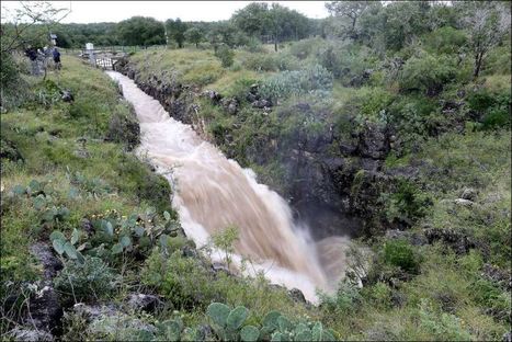
At this sinkhole, about 500 cubic feet of water per second is disappearing into the earth, the equivalent of an Olympic-sized swimming pool every three minutes, according to an engineer with the Edwards Aquifer Authority. For as much water reaches the aquifer at this spot, far more infiltrates through porous rock across South-central Texas.
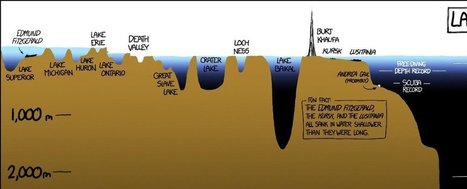
"The depths below the ocean’s surface comprise a staggering 95 percent of the Earth’s living space, and much of it is unexplored by humans. To put into perspective just how deep the oceans go, this XKCD comic, (hi-res image). Most of the ocean doesn’t even see sunlight. Even scientists aren’t familiar with everything that’s down there."
Global warming has raised global sea level about 8" since 1880, and the rate of rise is accelerating. Rising seas dramatically increase the odds of damaging floods from storm surges.
On occasion, we are reminded of how utterly captivating and gorgeous nature is, its visual poetry surrounds us. It just takes a step back, a shift in perspective, to realize how amazing the constructs of this planet are; it’s a beautiful constant balance between order and entropy. Case in point, what appears to be well-crafted, intricate abstract paintings, or works of art, are in reality, mindblowing aerial images of Iceland."
"Unchecked development remains a priority in the famously un-zoned city, creating short-term economic gains for some, but long term flood risk for everyone."
"So how gorgeous is Norway? From its majestic wildlife, captivating Northern Lights shows, and snowy mountains, to its vivid landscapes, and mystifying fjords, Norway is a must-visit destination for anyone who loves the outdoors. Plus, opportunities for hiking, kayaking, glacier climbing, fishing, and skiing are endless! If Noway wasn’t already on your travel bucket list, I bet it is now!"
My wife lived in Norway for 18 months, and her love for this country is infectious. The stunning physical geography leads to some equally magnificent cultural landscapes that were forged in a very rugged, inhospitable environment for early human settlers.
"A group of geologists say they've enough evidence to confirm the existence of a new continent. Writing in the journal of the Geological Society of America, the group named the eighth continent 'Zealandia.' Scientists argue for an 8th continent, Zealandia, in the Geological Society of America."
With 94% of Zealandia lying under water, most average people around the world will not care if National Geographic prints maps with an eighth continent. As cynical as that may be, geography should not be settled by human emotions and cultural expectations. Geography is a discipline that aims for understanding and precision. If continents are to be decided by continental shelves, rather than human cultural and ethnic patterns, then Eurasia is a continent and so is Zealandia. This latter outlook of focusing on physical geography is far more neutral and scientific. I would argue that is also more 'progressive'. Humans originate from one place (Africa) and are all one species. We have far more similarities than differences. Orienting our worldview to see that cultural geography is not the final arbiter of truth would ultimately bring people together. The logic follows that by acknowledging Zealandia, there is precedent for greater accuracy based on science, allowing geographers to teach about Eurasia. This is significant because it would alter the perception that Asians and Europeans are extremely distinct and separate groups due to a distorted notion that they lived on separate continents. The truth is that both groups existed on the same continent and were often brought into contact with each other throughout history. This idea, however, would further shatter the notion of a "pure, homogeneous Europe." Europe is only a "continent" because white Europeans were the first to possess the right combination of "guns, germs, and steel" to conquer other societies and elevate their own group's cultural status. Despite nature's evidence, Europeans awarded themselves an entire continent. In reality, Europe is a large peninsula of Asia. Just as Zealandia is an eighth continent sleeping underneath the waves.
This is interesting to think about. What decides what separates continents, is it geological barriers, is it culture, is it ethnic origin, or maybe even plate tectonics? Either way you look at it New Zealand makes a great case for why they could become to be considered the eighth continent. I could argue either way, to keep it simple and go by culture and geological commonalities (Oceania Islands) I would prefer it does not form its own continent. These geologist would argue otherwise.
A costly plan to build floating islands shows how climate change is pushing the search for innovative solutions, but some critics ask who will ultimately benefit.
This article was about the whale and how they were repopulating and how the whale hunting was banned in the 70s. I think this article was really good because use it talked about whales.
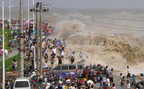
For hundreds of years, on the eighth month of the lunar calendar, people have gathered along the shores of China’s Qiantang River at the head of Hangzhou Bay to witness the waves of its famous bore tide. Higher-than-normal high tides push into the harbor, funneling into the river, causing a broad wave that can reach up to 30 feet high. If the waves surge over the banks, spectators can be swept up, pushed along walkways or down embankments. Below, I’ve gathered images from the past few years of the Qiantang bore tides.
Death Valley,California - Giant boulders in the desert look as though their moving all on their own! But could weird weather be behind these roving rocks
"Obsessed as we are with cartography we in Staridas Geography perceive any aspect of the actual 3D World as a constant opportunity for another pretty map creation!"
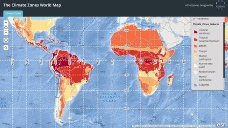
Fun way for students to learn about the diverse climates around the world, by selecting a location on the map students are shown the climatic data of the selected place.
"This case study considers the pros and cons of cotton production in Uzbekistan. Since the country's independence from the Soviet Union in 1991, revenues from cotton taxation have contributed substantially to developing the industrial sector, boosting the current account, achieving energy and food-grain self-sufficiency, and buffering domestic shocks in food and energy prices. Nonetheless, some argue that the state procurement system hampers the development of the agricultural sector. Often the payments for cotton hardly cover farmers' production costs, and the quasi mono-culture of cotton production has adversely affected environmental sustainability."
As everyone knows, water is key. We usually talk about water in geography has a way to export/import or for key military purposes. Here we are talking about survival and certain states within in India (29 to be exact) that were suffering through a drought and whose rivers had been completely dried up. India has tried a new plan to try to get water to these areas, by diverting water from there other rivers to these states. This is an interesting way to try to deal with this problem, however is it really feasible to do this? Would this eventually causes problems in the areas in which we are taking the water from? Also this would be very expensive and India , who is still a growing country, could hurt them economically for years to come. No one has said this will work and while yes, its horrible to see what has happen to these areas, but is this just a quick fix. What would the plan be for a future drought, is there anyway to come up with a better plan? Possibly will these people need to move in the future. Our rivers and lands are constantly changing so as people we might have to move away from areas that which were once habitable, but now may not be.
Extreme drought combined with inefficient agricultural practices and the depletion of groundwater resources have creates a water crisis in India. However the solution to the drought seems poorly planned and likely to fail. There is no evidence showing that a massive water diversion project like this will succeed in alleviating the effects of such a massive drought.
Drought is a factor of the physical geography of an area that is in trouble. India is heavily depended on monsoon rains, and for two years have no received what they normally do, and 330 million people are affected by it. The country is planning to divert different rivers to solve the issue. "The government says the scheme will irrigate 35,000 hectares of land and generate 34,000 megawatts of electricity." This will exponentially help those dealing with the water crisis, but also help with other thing such as electricity.
Three decades later, it’s not certain how radiation is affecting wildlife—but it’s clear that animals abound.
It may seem strange that Chernobyl, an area known for the deadliest nuclear accident in history, could become a refuge for all kinds of animals—from moose, deer, beaver, and owls to more exotic species like brown bear, lynx, and wolves—but that is exactly what Shkvyria and some other scientists think has happened. Without people hunting them or ruining their habitat, the thinking goes, wildlife is thriving despite high radiation levels.
To get content containing either thought or leadership enter:
To get content containing both thought and leadership enter:
To get content containing the expression thought leadership enter:
You can enter several keywords and you can refine them whenever you want. Our suggestion engine uses more signals but entering a few keywords here will rapidly give you great content to curate.


 Your new post is loading...