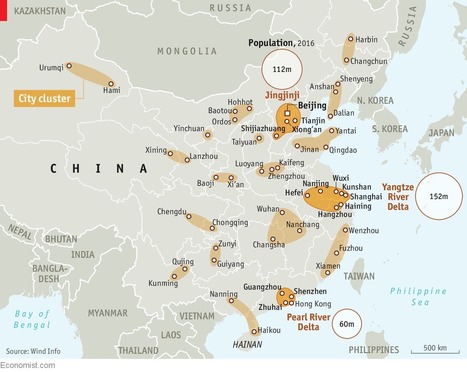
"China's urbanization is a marvel. The population of its cities has quintupled over the past 40 years, reaching 813m. By 2030 roughly one in five of the world’s city-dwellers will be Chinese. But this mushrooming is not without its flaws. Restraining pell-mell urbanization may sound like a good thing, but it worries the government’s economists, since bigger cities are associated with higher productivity and faster economic growth. Hence a new plan to remake the country’s map.
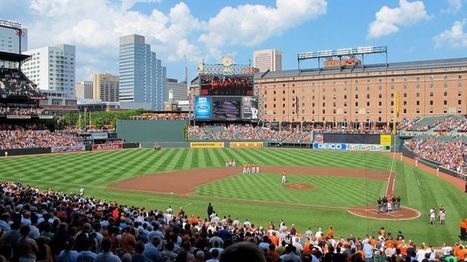
"In 1992, the Baltimore Orioles opened their baseball season at a brand new stadium called Oriole Park at Camden Yards, right along the downtown harbor. The stadium was small and intimate, built with brick and iron trusses—a throwback to the classic ballparks from the early 20th century. It was popular right from the start.
These new Populous ballparks are small and old fashioned-looking but they also feature modern amenities—comfortable seats and fancy foods. And while designed to be different, they tend to follow a similar aesthetic format, featuring a lot red brick and green-painted iron. These new parks also feature asymmetrical playing fields, which are in many cases dictated by the surrounding cityscape."
Freedom from cars, freedom from sprawl, freedom to walk your city! City planner Jeff Speck shares his "general theory of walkability" -- four planning principles to transform sprawling cities of six-lane highways and 600-foot blocks into safe, walkable oases full of bike lanes and tree-lined streets.
Austin's Mueller neighborhood is a new-urbanist dream, designed to be convivial, walkable and energy-efficient. Every house has a porch or stoop, and all the cars are hidden away.
After moving here, respondents said, they spend an average of 90 fewer minutes a week in the car, and most reported higher levels of physical activity. The poll results seem to validate new-urbanist gospel: good design, like sidewalks, street lighting, extensive trails and parkland, can improve social and physical health. Part II: A Texas Community Takes on Racial Tensions Once Hidden Under The Surface.
Tags: housing, urban, planning, urbanism, unit 7 cities, neighborhood, podcast.
This article focuses on an Austin community with a Utopian atmosphere. Beginning the construction in 2007, Mueller neighborhoods are very uniform; two story, two car garage in the back, and a porch in the front. This article refers to Urbanization
The article describes the master planned community of Mueller. Mueller is filled with parks and green spaces. In addition, every house has a porch and a garage in the back of the house to encourage communication between people and neighbors. Also everything is located close together so it is very easy to walk to the store instead of driving. Many houses employ solar panels for their energy and use fuel efficient hybrid cars.
Located centrally near downtown Austin this community was based on the concepts of new urbanism and uses effective and efficient methods to create a healthy and fresh neighborhood for both the people and the environment. New Urbanism is a concept which counters urban sprawl with urban revitalizations, sustainable development, and suburban reforms. The communities following the principles of New Urbanism are often designed compactly to promote a sense of community and place.
The Mueller community was developed from an old airport. I had the chance to visit this community on an APHUG field trip because it was so close. We were able to see the reasons why the community was developed and learned about innovated communities.
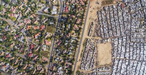
"I agree with you, I think that the images are chilling. And they communicate so well what is otherwise a very complicated and nuanced issue to discuss—separation, segregation, history, disenfranchisement. But the images cut right to the heart of the matter, which is that these separations are not right" This is a quote in the article from the man that took the pictures (Johnny Miller). These photos show us the lines of segregation that continues even in a post Apartheid South Africa. These are amazing images and really quite unbelievable. We think of different segregation here in America, but what these photos show are unlike anything that I have personally seen. As stated in the article the author hopes to create conversations about these separations. We see planned spatial separations that we created by city planners and we must used these as lessons going forward and as jumping off points to discuss. These shocking images can help inform us as a society that we must improve our social issues and if we don't we will continue to see issues like this grow both here in South Africa and around the world. One can see while tensions would be so high as a clear divide in living standards can rightfully cause anger. Eventually this anger leads to hate and this hate leads to an up rise in the people.
South Africa is one of the few countries that has a similar history in regards to racial segregation as America. What makes their case unique is that the African population was there first and the English came in and created a system in which they were superior. Although they have been officially desegregated for almost 20 years, these photos show that there are still underlying issues that exist. These photos reveal that on one side of a particular area, the homes look like a typical suburban area where right across from that there are areas that resemble slums. The areas that are more developed and wealthy have a majority white population and the poorer, less developed areas have large black populations. The affects of segregation are long lasting and not solved overnight. Just because government policies say that discrimination on a racial basis is illegal, doesn’t mean that society will neatly reorganize itself. I think that the craziest part of this for me was that even the landscaping is vastly different despite the closeness of the two areas. The wealthier part has lush green and the poorer parts have dirt and sand. This an example of physical geography providing evidence for a societal separation.
Just because a formal social construct - an idea in the human mind - changes, does not mean that change, or desire to alter course, is reflected in the real world. While the idea of apartheid in South Africa came to an end, the real world in the form of urban geography has yet to catch up. The urban planning under apartheid still carries the legacy of color codes and demarcated boundaries between "races" in order to cement socioeconomic inequity. This situation in South Africa is similar to the United States after the Civil Rights movement ended the era of Jim Crow. Even though laws were passed, the geography remained largely untouched. Black neighborhoods remained socially and economically segregated - the only difference being that the law did not mandate this. The law never stipulated geographic changes or economic prescriptions like wealth redistribution. It turns out that human geography and philosophical principles can be at odds with each other, as demonstrated by the aerial photographs of South African cities.
"The Catalan capital’s radical new strategy will restrict traffic to a number of big roads, drastically reducing pollution and turning secondary streets into ‘citizen spaces’ for culture, leisure and the community. Black routes allow public transport and cars at 50km/h, while green routes only allow private vehicles at 10km/h to prioritize pedestrians and cycling."
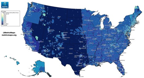
An unconventional look at American roads, mapped by their speed limits.
The above map, from MetricMaps, illustrates that abrupt division using local speed limit data. That map shows the maximum local speed limit for any local roads or highways in each Census block group in the U.S. The nationwide contrasts are striking, but so are the local ones: Zoom in to an individual city like Los Angeles, and the darker arteries effectively outline highways.
When looking at this map, before looking at the actual index of the colors that determine the speeds, I could already tell which areas would have a higher speed level and which ones had a lower speed level. Looking at the map, the mountain region had higher speed levels. I believe this is accurate because there isn't much going on in this areas. There is tons of land and direct roads that lead to other states. These states, like Wyoming or Montana, aren't really tourist attractions. In the New England area, one could see that the speed levels are lower and I would assume it would be because there are more people in this area. There is not a lot of land here for agriculture. I would say this map seems pretty accurate.
Speeding in America can lead to some people having road rage because they are in a hurry. However, by looking at the map of speed limits in the United States, the area that would probably see less cases of road rage is in the Central and Plains states that have a speed limit of over 75 miles per hour. This will also help reduce people who speed because they are in a rush to get from point a to point b. In areas such as Rhode Island, where the speed limits reach up to 65 miles per hour, people tend to rush and get angry with people who are going below the speed limit and lead to the need for speed to calm themselves down. Thus, it also includes a higher risk for getting a speeding ticket which will be expensive.
"In just a few generations, we have tightly restricted American kids' freedom to roam, play, and become self-sufficient. The percentage of children walking and bicycling to school has plummeted from almost 50 percent in 1969 to about 13 percent today. Although distance from school is often cited as the main barrier to walking and bicycling, many families still drive when schools are close to home. According to the Safe Routes to School National Partnership, driving accounts for about half of school trips between 1/4- and 1/2-mile long — which in most cases shouldn't take kids much more than 10 minutes to walk."
Let's make "10 not 12!" a new mantra for saving our cities and towns.
[12 foot lanes] are wrong because of a fundamental error that underlies the practice of traffic engineering—and many other disciplines—an outright refusal to acknowledge that human behavior is impacted by its environment.
"Unchecked development remains a priority in the famously un-zoned city, creating short-term economic gains for some, but long term flood risk for everyone."
Whenever international attention is drawn to a city or specific place for an extened period of time, every city will make strides to make their city look as good as possible to international visitors. In the case of Rio, that involved altering bus routes and relocating poor populations to areas that would be away from the gaze of the international community. Using urban planning to reshape entire neighborhoods and essentially the makeup of the city itself is rarely undertaken and does not occur withour massive side effects as shown in the video with violence and protests against such actions.
"New Urbanism is a planning and development approach based on the principles of how cities and towns had been built for the last several centuries: walkable blocks and streets, housing and shopping in close proximity, and accessible public spaces. In other words: New Urbanism focuses on human-scaled urban design."
New urbanism is a type of urbanization. In new urbanism, everything is built so that it's in walking distance of other things mostly such as Winn Dixie and McDonald's in Callahan.
As the 2017 APHG exam has ended, some people have asked for more resources on new urbanism. Here is information from New Urbanism (dot org) the Congress on New Urbanism for teachers and students that are reassessing the Free Response Questions.
"Although we seldom think about them this way, most American communities as they exist today were built for the spry and mobile. We've constructed millions of multi-story, single-family homes where the master bedroom is on the second floor, where the lawn outside requires weekly upkeep, where the mailbox is a stroll away. We've designed neighborhoods where everyday errands require a driver's license. We've planned whole cities where, if you don't have a car, it's not particularly easy to walk anywhere — especially not if you move gingerly.
This reality has been a fine one for a younger country. Those multi-story, single-family homes with broad lawns were great for Baby Boomers when they had young families. And car-dependent suburbs have been fine for residents with the means and mobility to drive everywhere. But as the Baby Boomers whose preferences drove a lot of these trends continue to age, it's becoming increasingly clear that the housing and communities we've built won't work very well for the old."
I can definitely see this as a real problem. Both my Uncle and my Great Uncle moved their condos from ones that had numerous steps to climb to the second floor to more elder-friendly options. My Great Uncle even went a step further to move him and his wife to a senior living community, where there food, entertainment, etc. is all provided within an enclosed neighbourhood with other people of their age group. More of these communities that act like oversized retirement homes could be the answer. They give the illusion of suburban living, something the baby boomers liked, while providing the accessibility they need.
Forget New York, London or Hong Kong. Here are seven cities that are racing up the rankings of the world's richest, and will be among the top 10 by 2025, according to researchers from McKinsey.
These seven major cities in this article are to be rich within the next 10 years. Bergen is the second most populated city in Norway and is already the forefront of Norway. While in Hwaseong it is home to the research facilities outside South Korea south of Seoul. And in Rhine Ruhr, Germany, it is already successful in urban areas. It is also the third largest city in Europe, trailing Paris and London.
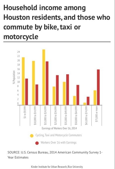
"Urban planners are noticing a cultural gap between bike advocates and others who bike. Planners see a particular type of cyclist: a working-class person – usually a minority and often a recent immigrant – riding to work on whatever type of bike he can get his hands on. Those cyclists are men and women for whom biking isn’t an environmental cause or a response to an urban trend but a means of transportation that’s cheaper than a car and faster than walking."
"The evolving role of cities and regions presents planning challenges as urban areas are work to achieve particular social, economic and environmental goals. This video explores a range of cities to examine how fully integrated planning, design, engineering and management capabilities can help to improve cities."
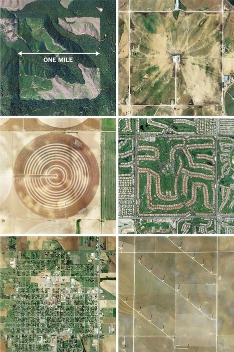
"The images here, taken from the Instagram account @the.jefferson.grid show just a few of the landscapes that can be squeezed into the one-mile squares. The idea behind this sprawling checkerboard emerged after the Revolutionary War. As the United States expanded westward, the country needed a systematic way to divide its newly acquired lands. The original colonies were surveyed using the British system of 'metes and bounds,' with parcels delineated using local geography.
That approach doesn’t scale very well, and Jefferson proposed to slice the young United States into gridded plots of land. Jefferson's idea became a reality in 1785 when it was enacted as the Public Land Survey System. Today his grid covers much of the country, and it is still used to survey federal lands — an idea that shaped the physical landscape of half a continent."
Tags: images, land use, landscape, social media, planning, spatial, scale, historical.
A big portion of China's economic boom the last few decades has been linked to the transformation of what used to be a predominantly agrarian civilization to an economic engine fueled by rapid urbanization. This 2011 video from the Economist is still highly relevant today.
This video talks about how the dispersion of the population of China is changing, and becoming more urban. Many young rural citizens are choosing to go to the cities and find work there instead of staying and working on farms, but this poses the problem of who is tending to the crops in the rural areas, and because the young population is leaving it is often older members of the families. These younger citizens still often have land in the rural areas and many will return as they get older and continue to work on the fields, the country wants to find a way to keep these younger citizens in the urban areas as to continue to urbanize the country.
To get content containing either thought or leadership enter:
To get content containing both thought and leadership enter:
To get content containing the expression thought leadership enter:
You can enter several keywords and you can refine them whenever you want. Our suggestion engine uses more signals but entering a few keywords here will rapidly give you great content to curate.


 Your new post is loading...