Guest columnist Laura Hebert explores the philosophy of maps. Do they represent or create the reality of our geography?
Get Started for FREE
Sign up with Facebook Sign up with X
I don't have a Facebook or a X account


 Your new post is loading...
 Your new post is loading...
Your new post is loading...
Guest columnist Laura Hebert explores the philosophy of maps. Do they represent or create the reality of our geography? 
No comment yet.
Sign up to comment
From
www

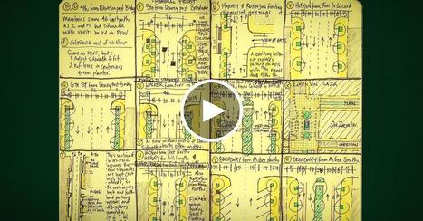
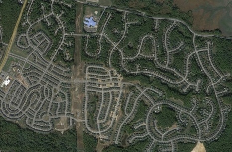
Freedom from cars, freedom from sprawl, freedom to walk your city! City planner Jeff Speck shares his "general theory of walkability" -- four planning principles to transform sprawling cities of six-lane highways and 600-foot blocks into safe, walkable oases full of bike lanes and tree-lined streets. Via CT Blake

GTANSW & ACT's curator insight,
August 31, 2017 8:01 PM
Enhancing urban liveability - creating better cities for the future
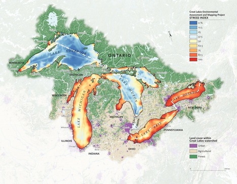
"It’s no secret that the Great Lakes are suffering tremendous ecological strain — Lake Erie was even pronounced “dead” for a time during the 1960s because of an overload of phosphorus from municipal waste. Back in 1615, though, when the entire region was pristine and explorers Samuel de Champlain and Étienne Brûlé gazed out together from Lake Huron’s shores, they dubbed it la mer douce, 'the sweet sea.' Today roughly one-quarter of Canada’s population and a 10th of America’s population drink from the Great Lakes basin; the beleaguered lakes alone hold more than a fifth of Earth’s freshwater." Via Mike Busarello's Digital Storybooks

Lou Salza's curator insight,
April 15, 2017 11:52 AM
These lakes are a tremendous resource, not only for the region but the nation as well. They need our attention and protection.-Lou 
Nicole Canova's curator insight,
February 8, 2018 9:58 PM
It is amazing, in a sad way, to see how in just four centuries these lakes have gone from "la mer douce" to "dead." This map is a reminder of the damage humans do to the environment on a daily basis, and of the importance of protecting our natural resources. Considering the fact that these lakes hold roughly one fifth of all of the fresh water on the planet and provide drinking water for millions of people in both the U.S. and Canada, we need to think about the impact we have on the world around us and how that impact can come back to bite us on the rear end.

"The states are colored red or blue to indicate whether a majority of their voters voted for the Republican candidate, Donald Trump, or the Democratic candidate, Hillary Clinton, respectively. There is significantly more red on a traditional election maps than there is blue, but that is in some ways misleading: the election was much closer than you might think from the balance of colors, and in fact Clinton won slightly more votes than Trump overall. The explanation for this apparent paradox, as pointed out by many people, is that the map fails to take account of the population distribution. It fails to allow for the fact that the population of the red states is on average significantly lower than that of the blue ones.
Via Mike Busarello's Digital Storybooks
The process of making orange juice on a humongous scale. The Americans drink so much of the stuff I'm surprised they still have any left for export. Via Mike Busarello's Digital Storybooks
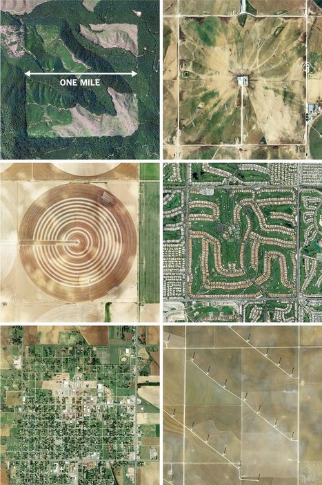
"The images here, taken from the Instagram account @the.jefferson.grid show just a few of the landscapes that can be squeezed into the one-mile squares. The idea behind this sprawling checkerboard emerged after the Revolutionary War. As the United States expanded westward, the country needed a systematic way to divide its newly acquired lands. The original colonies were surveyed using the British system of 'metes and bounds,' with parcels delineated using local geography.
That approach doesn’t scale very well, and Jefferson proposed to slice the young United States into gridded plots of land. Jefferson's idea became a reality in 1785 when it was enacted as the Public Land Survey System. Today his grid covers much of the country, and it is still used to survey federal lands — an idea that shaped the physical landscape of half a continent."
Tags: images, land use, landscape, social media, planning, spatial, scale, historical. Via Mike Busarello's Digital Storybooks

Dyna-e International's curator insight,
September 1, 2015 12:32 PM
No such thing as being off the grid really. ~ Ron Sandack

Let's make "10 not 12!" a new mantra for saving our cities and towns. [12 foot lanes] are wrong because of a fundamental error that underlies the practice of traffic engineering—and many other disciplines—an outright refusal to acknowledge that human behavior is impacted by its environment. Tags: transportation, planning, spatial, scale.
In strictly economic terms, sprawl is inefficient. Spread people out, and it takes them longer to drive where they need to go, and it costs them more in gas money to get there. Disperse a few people over a lot of land, and that land is used inefficiently, too. Then give those people roads and sewers — you’d need a lot more of both to serve 20 households living over a square mile than 20 on the same block. And that's to say nothing of the costs of fire and police service when people live far apart. Tags: planning, sprawl, scale. Via Dean Haakenson
GTANSW & ACT's curator insight,
June 27, 2015 12:01 AM
Affordability impacts on people's choices about where to live and in turn impacts on access to goods and services, community identity and social connectedness in many outlying suburbs
"The world is becoming more and more interconnected. Globalization changes how people consume, work and live almost everywhere on the world. Today, many economic, political, cultural or ecological relationships are not explainable from a national perspective. At the same time, a controversial debate about the consequences of globalization has begun." Via Michael Miller

Nicole Canova's curator insight,
January 18, 2018 7:10 PM
This video does a good job of explaining globalization and the effects it has on transportation, communication, economy, politics, and culture around the world. It also discusses some of the consequences of the world becoming a smaller place.
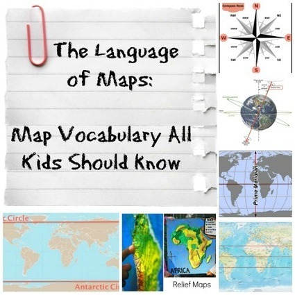
The vocabulary and concepts of maps kids should learn to enhance their map-skills & geography awareness. Concise definitions with clear illustrations.

Anita Vance's curator insight,
June 30, 2014 8:54 AM
This article helps give an early start to map skill implementation - even at the earliest levels. 
DTLLS tutor's curator insight,
July 1, 2014 5:04 AM
Love this website. Not just this article, but the whole idea. Have a little browse around...

A geographer and a biologist at Salem State University team up to curate a new exhibition, featuring confounding views from both satellites and microscopes Via Mike Busarello's Digital Storybooks

Siri Anderson's curator insight,
October 18, 2013 12:46 PM
Gives a whole new meaning to the sense of scale. |

From
www
Amazon’s zero-profit strategy is a disaster for anyone who goes up against it.

Mr Mac's curator insight,
June 22, 2017 9:35 AM
Unit 5 - Commercial Agriculture, Agribusiness, Food Distribution; Unit 6 - Services, Distribution of Services, Service and Technology
"New Urbanism is a planning and development approach based on the principles of how cities and towns had been built for the last several centuries: walkable blocks and streets, housing and shopping in close proximity, and accessible public spaces. In other words: New Urbanism focuses on human-scaled urban design." Via CT Blake

aliyah marie scarb's curator insight,
May 25, 2017 10:34 PM
New urbanism is a type of urbanization. In new urbanism, everything is built so that it's in walking distance of other things mostly such as Winn Dixie and McDonald's in Callahan.

Deanna Wiist's curator insight,
September 12, 2017 9:02 PM
As the 2017 APHG exam has ended, some people have asked for more resources on new urbanism. Here is information from New Urbanism (dot org) the Congress on New Urbanism for teachers and students that are reassessing the Free Response Questions.
Tags: place, neighborhood, urban, planning, urbanism, scale.

"Washington may be the political center of the free world, but its 670,000 residents don’t have a say in the national legislature. What they do have is a nonvoting delegate in the House of Representatives. Eleanor Holmes Norton can introduce legislation and vote in committee, but she can’t vote on the House floor. Over the course of 13 terms, the 'Warrior on the Hill' been fighting to change that."

Kelly Bellar's curator insight,
December 13, 2016 4:21 PM
If you haven't discovered the podcast "Placemakers" you are missing out. In this episode, they explore the competing political context of Washington D.C. Since this podcast ran, the citizens of the district voted overwhelmingly for statehood, but since the governance of the district operates more at the national scale then on the local level, statehood is not happening anytime soon.
Tags: place, podcast, political, autonomy, scale, Washington DC.
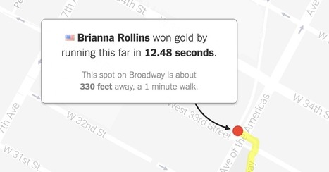
"What would Olympic races look like if they took place near you? Enter your address below to find out, or keep clicking the green button to explore races that begin in where you live."
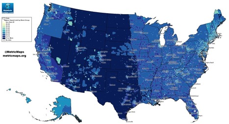
An unconventional look at American roads, mapped by their speed limits.
The above map, from MetricMaps, illustrates that abrupt division using local speed limit data. That map shows the maximum local speed limit for any local roads or highways in each Census block group in the U.S. The nationwide contrasts are striking, but so are the local ones: Zoom in to an individual city like Los Angeles, and the darker arteries effectively outline highways.

Alex Vielman's curator insight,
September 20, 2015 10:36 PM
When looking at this map, before looking at the actual index of the colors that determine the speeds, I could already tell which areas would have a higher speed level and which ones had a lower speed level. Looking at the map, the mountain region had higher speed levels. I believe this is accurate because there isn't much going on in this areas. There is tons of land and direct roads that lead to other states. These states, like Wyoming or Montana, aren't really tourist attractions. In the New England area, one could see that the speed levels are lower and I would assume it would be because there are more people in this area. There is not a lot of land here for agriculture. I would say this map seems pretty accurate. 
Raymond Dolloff's curator insight,
October 12, 2015 2:13 PM
Speeding in America can lead to some people having road rage because they are in a hurry. However, by looking at the map of speed limits in the United States, the area that would probably see less cases of road rage is in the Central and Plains states that have a speed limit of over 75 miles per hour. This will also help reduce people who speed because they are in a rush to get from point a to point b. In areas such as Rhode Island, where the speed limits reach up to 65 miles per hour, people tend to rush and get angry with people who are going below the speed limit and lead to the need for speed to calm themselves down. Thus, it also includes a higher risk for getting a speeding ticket which will be expensive.
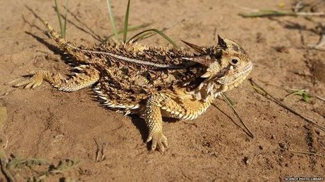
"Scientists have unpicked how the skin of the Texas horned lizard funnels water towards its mouth - and copied the principles in a plastic version. This reptile can collect water from anywhere, including the sand it walks on; the fluid then travels to its mouth through channels between its scales. A German-Austrian team quantified the skin's key features, notably the way its grooves narrow towards the snout. The bio-inspired plastic copy could have some engineering applications. Writing in the Journal of the Royal Society Interface, the researchers suggest that the "passive, directional liquid transport" they have described might find a home in distilleries, heat exchangers, or small medical devices where condensation is a problem." Via Miguel Prazeres, Jocelyn Stoller

"It's difficult to comprehend the ridiculous amounts of water that have fallen in such a short time in a state that, until recently, had been in the grip of a historic drought. But one place to start would be to look at reservoir levels in the state. In the past 30 days, Texas reservoirs have gone from being 73 percent full to 82 percent full, according to data maintained by the Texas Water Development board. All told, about 8 million acre-feet of water have flowed into the state's reservoirs." Via Scott Langston
![The Speed Burden [Costs of Sprawl] | Human Interest | Scoop.it](https://img.scoop.it/FylN4HpUjR3Po2vIJ-TKTjl72eJkfbmt4t8yenImKBVvK0kTmF0xjctABnaLJIm9)
The need for speed devours huge chunks of American cities and leaves the edges of the expressways worthless. Busy streets, for almost all of human history, created the greatest real estate value because they delivered customers and clients to the businesses operating there. This in turn cultivated the highest tax revenues in town, both from higher property taxes and from elevated sales taxes. But you can't set up shop on the side of an expressway. How can cities afford to spend so much to create thoroughfares with no adjoining property value?

Alexa Earl's curator insight,
March 14, 2015 10:48 AM
This blog really made me realize what an impact humans are to the environment. They compare different cities and talk about the impacts and it really showed me how humans have built up cities. 
Brian Wilk's curator insight,
March 21, 2015 6:12 PM
A side by side comparison at first blush is striking but the devil is in the details. Florence, Italy is a city of only 368,000 while the Atlanta metro area is about 4.5 million. Agree that sprawl is ineffective real estate and efficiency wise, but fuel prices may be having a counter effect on the reduction of sprawl. It is much less expensive to commute given the price of oil at its current levels and the millennials will have a say in this urban sprawl contracting or expanding. Many do not own cars, relying on commuter systems within the city to get around. This in theory should drive down demand for fossil fuels, culminating in reduced prices for gasoline. If the infrastructure is already built, was is the cost to maintain it, given the static population of the large metro areas? Interesting to see how this plays out.
"Physicist Geoffrey West has found that simple, mathematical laws govern the properties of cities — that wealth, crime rate, walking speed and many other aspects of a city can be deduced from a single number: the city's population. In this mind-bending talk from TEDGlobal he shows how it works and how similar laws hold for organisms and corporations." Via Mike Busarello's Digital Storybooks

Built 4 Betterness Ed van den Berg's curator insight,
December 14, 2014 3:17 PM
Not surprisingly the DNA of cities is a follow-up of human DNA and understanding this will explain and predict how the body of a city will develop! 
SRA's curator insight,
April 16, 2015 2:10 AM
The idea that cities are just organisms that are satisfying the laws of biology is interesting. Especially because Physicist Geoffrey West brings the idea of Scalability which by definition is, the ability of a system, network, or process to handle a growing amount of work in a capable manner or its ability to be enlarged to accommodate that growth. What’s mind blowing to me is that the system that is referred to here is human interaction. We create these cities through our interaction and experience. With a growth rate of 1,000,000 people every year the math adds up to an agreeable 15% rise in income levels, patents, and super creative people every year which is undoubted a win for civilization and society. But with that we must keep in mind also this means a 15% increase in things like deadly disease, crime, poverty, and ecological issues leading to further degradation of our planet. This unbounded growth means the system is destined to collapse. The math behind cities doesn't lie if we don’t prepare cities have a fate to die like every other organism in Biology. So it is up to us to create and innovate to sustain this growth and avoid the collapse. But we must do so at a forever increasing pace. Which subsequently is also part of another system predetermined to collapse. What I mean is what happens when we cannot innovate fast enough to sustain this growth? - Caleb Beckett 
BrianCaldwell7's curator insight,
April 5, 2016 8:14 AM
While corporations rise and fall, it is quite rare for a city to entirely fail as an economic system. Huge cities have some negative consequences, but the networks that operate in the city function more efficiently on economies of scale in a way that offsets the negatives. Increasing a city's population will continue to improve the economies of scale (larger cities have higher wages per capita, more creative employment per capita, etc.). However, this growth requires major technological innovations to sustain long-term growth.
Tags: urban, planning, megacities, industry, economic, scale, TED, video.
"Superclusters – regions of space that are densely packed with galaxies – are the biggest structures in the Universe. But scientists have struggled to define exactly where one supercluster ends and another begins. Now, a team based in Hawaii has come up with a new technique that maps the Universe according to the flow of galaxies across space. Redrawing the boundaries of the cosmic map, they redefine our home supercluster and name it Laniakea, which means ‘immeasurable heaven’ in Hawaiian. Read the research paper here."

They've driven prices so low that Mexican growers are giving up. For the first time ever, many of the farmers who supply Mexican drug cartels have stopped planting marijuana, reports the Washington Post. "It's not worth it anymore," said Rodrigo Silla, a lifelong cannabis farmer from central Mexico. "I wish the Americans would stop with this legalization." Facing stiff competition from pot grown legally and illegally north of the border, the price for a kilogram of Mexican schwag has plummeted by 75 percent, from $100 to $25.

Gene Gagne's curator insight,
December 2, 2015 9:37 AM
there is also a negative side affect on this and that is now that planting marijuana is not making any money for the growers it is time to move to bigger and more dangerous stuff. The united states though the government will not admit to, has a major drug usage problem and so it would be time to bring in another form of drug to make a profit. every so often there is something new that pops up on the streets and Americans want to experience them.
BrianCaldwell7's curator insight,
March 16, 2016 3:51 PM
Events that we think of as local (Washington and Colorado legalizing marijuana use) have national and global implications, especially in a globalized economy. This article is but one example of why geographers try to approach every issue at a variety of scales to more fully comprehend the ramifications and ripple effects of any given phenomenon.
|