Song: Midnight - Caravan Palace Applications: - Google Earth Pro - Adobe After Effects CC Locations: - 0:09 New York, USA - 0:17 Namib Desert, Namibia
Via mrhill
Get Started for FREE
Sign up with Facebook Sign up with X
I don't have a Facebook or a X account


 Your new post is loading...
 Your new post is loading...
Your new post is loading...
Song: Midnight - Caravan Palace Applications: - Google Earth Pro - Adobe After Effects CC Locations: - 0:09 New York, USA - 0:17 Namib Desert, Namibia Via mrhill 
No comment yet.
Sign up to comment

From
www

"Two archaeologists, who recently published their findings in the American Schools of Oriental Research, used Google Earth satellite images and drone photography to identify the outline of an enormous monument buried beneath sand and time at the UNESCO World Heritage site in Jordan." --Motherboard

Zavier Lineberger's curator insight,
March 29, 2018 3:38 PM
(Middle East) Using modern technology, archaeologists have discovered a new monument hidden underground in Petra. The find, dated around 150 B.C., is thought to be a ceremonial site with two platforms, pottery. columns, and a staircase carved out of stone. It is amazing that there are still new finds like this in the 21st century, but the history of the Middle East is so incredibly old, with so many extinct civilizations, that archaeologists will probably keep making new breakthroughs.

brielle blais's curator insight,
April 1, 2018 4:40 PM
Physical geography can be really cool as understanding the current land helps to also understand the past. Researchers finding new monuments like this in Petra shows the importance of knowing the land around you, or someplace important like where the UNESCO World Heritage Site.

While many skills have become obsolete in the digital age, map reading remains an important tool for building children's spatial reasoning skills and helping them make sense of our world.
Skuuppilehdet's insight:
Young people need to develop a mental map of their environs and an over-reliance on GPS/mapping apps are no substitute. When these youth become drivers, they are unprepared to make spatially/navigational decisions because they lack map reading skills. They might think that their apps can do all the work and that an old fashioned paper map is outdated technology, but their spatial thinking skills become atrophied. Spatial skills are crucial for understanding the world as a global citizen, to understand your local environs and for making scientific discoveries. So teach a kid how to read a map...the sooner the better.
Tags: education, K12, geography education, spatial, mapping.

Dewayne Goad's curator insight,
March 9, 2016 9:40 AM
Young people need to develop a mental map of their environs and an over-reliance on GPS/mapping apps are no substitute. When these youth become drivers, they are unprepared to make spatially/navigational decisions because they lack map reading skills. They might think that their apps can do all the work and that an old fashioned paper map is outdated technology, but their spatial thinking skills become atrophied. Spatial skills are crucial for understanding the world as a global citizen, to understand your local environs and for making scientific discoveries. So teach a kid how to read a map...the sooner the better.
Tags: education, K12, geography education, spatial, mapping. 
ApocalypseSurvival's curator insight,
March 11, 2016 9:13 AM
Young people need to develop a mental map of their environs and an over-reliance on GPS/mapping apps are no substitute. When these youth become drivers, they are unprepared to make spatially/navigational decisions because they lack map reading skills. They might think that their apps can do all the work and that an old fashioned paper map is outdated technology, but their spatial thinking skills become atrophied. Spatial skills are crucial for understanding the world as a global citizen, to understand your local environs and for making scientific discoveries. So teach a kid how to read a map...the sooner the better.
Tags: education, K12, geography education, spatial, mapping.
ApocalypseSurvival's curator insight,
March 11, 2016 9:15 AM
Young people need to develop a mental map of their environs and an over-reliance on GPS/mapping apps are no substitute. When these youth become drivers, they are unprepared to make spatially/navigational decisions because they lack map reading skills. They might think that their apps can do all the work and that an old fashioned paper map is outdated technology, but their spatial thinking skills become atrophied. Spatial skills are crucial for understanding the world as a global citizen, to understand your local environs and for making scientific discoveries. So teach a kid how to read a map...the sooner the better.
Tags: education, K12, geography education, spatial, mapping.
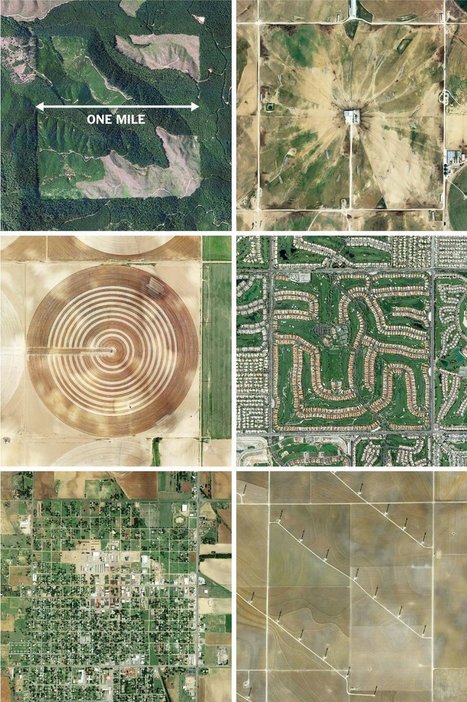
"The images here, taken from the Instagram account @the.jefferson.grid show just a few of the landscapes that can be squeezed into the one-mile squares. The idea behind this sprawling checkerboard emerged after the Revolutionary War. As the United States expanded westward, the country needed a systematic way to divide its newly acquired lands. The original colonies were surveyed using the British system of 'metes and bounds,' with parcels delineated using local geography.
That approach doesn’t scale very well, and Jefferson proposed to slice the young United States into gridded plots of land. Jefferson's idea became a reality in 1785 when it was enacted as the Public Land Survey System. Today his grid covers much of the country, and it is still used to survey federal lands — an idea that shaped the physical landscape of half a continent."
Tags: images, land use, landscape, social media, planning, spatial, scale, historical. Via Mike Busarello's Digital Storybooks

Dyna-e International's curator insight,
September 1, 2015 12:32 PM
No such thing as being off the grid really. ~ Ron Sandack
Slow linking to these, but Jeremy Crampton has two follow-up posts to my earlier sharing of Mary Beard's interesting piece on the last stages of writing a book – SPQR: A History of Ancient Rome. In... Via mrhill
View Full Lesson on TED-ED BETA: http://ed.ted.com/lessons/how-pandemics-spread In our increasingly globalized world, a single infected person can board a pl...
This is a great demonstration of why spatial thinking is critical to so many fields, including medicine.
Tags: diffusion, medical, historical, spatial. Via Matthew Wahl, GTANSW & ACT

Miles Gibson's curator insight,
November 23, 2014 11:33 AM
Unit 1 nature and perspectives of geography This video is about how a world wide pandemic can occur and has occurred in history. I thought this was interesting because it spoke of many specific events like the black death and the 2010 cholera outbreak in haiti, gave detailed information, and was very informal. This relates to unit 1 because it shows how pandemics and epidemics occur in a detailed way. It also shows how geography has related to epidemic outbreaks by showing disease spread maps and showing how doctors used this to solve the issue of it.
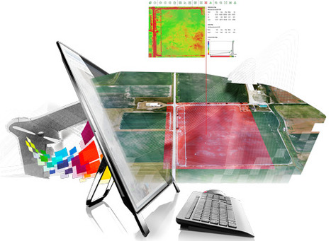
"Thousands of years ago, agriculture began as a highly site-specific activity. The first farmers were gardeners who nurtured individual plants, and they sought out the microclimates and patches of soil that favored those plants. But as farmers acquired scientific knowledge and mechanical expertise, they enlarged their plots, using standardized approaches—plowing the soil, spreading animal manure as fertilizer, rotating the crops from year to year—to boost crop yields. Over the years, they developed better methods of preparing the soil and protecting plants from insects and, eventually, machines to reduce the labor required. Starting in the nineteenth century, scientists invented chemical pesticides and used newly discovered genetic principles to select for more productive plants. Even though these methods maximized overall productivity, they led some areas within fields to underperform. Nonetheless, yields rose to once-unimaginable levels: for some crops, they increased tenfold from the nineteenth century to the present. Today, however, the trend toward ever more uniform practices is starting to reverse, thanks to what is known as 'precision agriculture.' Taking advantage of information technology, farmers can now collect precise data about their fields and use that knowledge to customize how they cultivate each square foot."
Tags: technology, food production, agriculture, agribusiness, spatial, GPS. Via Mike Busarello's Digital Storybooks

Cade Johns's curator insight,
December 2, 2015 9:57 AM
Agriculture has evolved very much over time to many different methods of growing things and theyve changed the way we affect the soil.-CJ 
Samuel bennett's curator insight,
January 10, 2017 11:50 AM
In this article it talks about the development of agriculture and how most of it started. This article relates to my world cultural geography class by telling how people used agriculture to provide for themselves and better there methods year after year. The use of technology and the pesticides they used to help there crops grow is similar in our class to the was technology was developed and helped out a lot in the fields and in everyday life. 
Alanna Thompson's curator insight,
January 10, 2017 1:17 PM
This is very interesting insight on how farmers use precision agriculture to customize how they cultivate each square foot of their fields. In my opinion precision agriculture is a good way for farmers to know exactly what they need to do to their field and what they should plant. It also is a way for them to make sure none of the areas within their field underperform.

A new study suggests vehicular travel affects children's ability to navigate their neighborhood and connect to their community.
We learn about the places around us by exploring. Literally our mental map is formed by making choices (in part through trial and error) and that process strengthens our spatial perception of the neighborhood. Research is showing that kids with a 'windshield perspective' from being driven everywhere are not able to draw as accurate maps as children for who walk and bike their neighborhood. The built environment and the transportation infrastructure in place play a role in developing spatial thinking skills for young minds.
This is a compelling article with some important implications. What are the ramifications for geographers? City planners? Educators? Families moving to a new neighborhood? Via Michael Miller

Victoria McNamara's curator insight,
December 11, 2013 10:52 AM
We may not realize it but when we take our kids out on drives to run errands or if we move to a different area we are ruining their understanding of the area they live in. Children often have a hard time of figuring out where they are if they constantly in a car looking at new places. This can cause them to lack a sense of direction and maybe have trouble remembering streets or landmarks near their homes.


Gabriel Olson's curator insight,
February 13, 2015 2:59 PM
We ought to know something about where our food comes from... 
Eden Eaves's curator insight,
March 24, 2015 1:04 AM
Unit 5 Some of these maps are easy to guess, such as cotton being grown in the south, but what about others like pigs being raised in the mid-west and North Carolina??? We are so used to having only to make a quick stop at the nearest grocery store to grab our weekly essentials that we don't always think about where it naturally comes from. Also preservatives have come so far as to keep things fresh for long periods of time that where it originates is not a problem because it can be shipped in a refrigerated truck with still time left for it to sit in your fridge for a few days. 
BrianCaldwell7's curator insight,
March 16, 2016 3:34 PM
This 12 question quiz is a great way to introduce students to spatial patterns of agricultural products in the United States. Sometimes just knowing regional stereotypes can be helpful, but being able to make an educated guess about where an agricultural product is comes from requires a basic understanding of economic and climate patterns. This quiz is a good way to test that knowledge and introduce them to these spatial patterns.
Tags: trivia, spatial, regions, food, economic, food production, agriculture.

Flo Cuadra Scrofft's curator insight,
March 21, 2015 9:38 PM
This presentation talks about the misconceptions of geography and about what it really involves. Geographers describe and try to explain how locations interact and relate to one another; are arranged the way they are; and have become what they are now. They also use critical thinking to project what the world might look like in the future. As there's usually so many questions that have to be answered, geography is an interdisciplinary work, meaning that it is a blend of natural sciences, social sciences, and humanities. Geographers also develop other skills, such as mapping and graphing (spatial representation skills) and development of verbal concepts, frameworks and mathematical models (spatial theorizing skills). Geography, therefore, can be used to study many issues, such as climate change, sustainability, human rights, among others. Reflection- as the presentation accurately shows, many people believe that geography is just about memorizing countries and our world's natural resources locations, but in reality, geography goes much deeper than that. Geography is about asking questions and trying to come out with the best answers in order to solve issues that can range from local usage of land to international security. 
Gregory Stewart's curator insight,
August 29, 2015 9:37 AM
Prezi created by students interested in the field of geography. 
Alex Smiga's curator insight,
September 7, 2015 4:26 PM
Seth Dixon's insight:
This Prezi was created by students from theSyracuse Geography Department as part of a Senior Seminar to explain the disciple, the major and its utility. This is a great recap of the discipline, the major and it's utility.

Thanks to demographics, the Republicans have a virtual stranglehold on the House of Representatives.
"Why are all the gas stations, cafes and restaurants in one crowded spot? As two competitive cousins vie for ice-cream-selling domination on one small beach, discover how game theory and the Nash Equilibrium inform these retail hotspots."

CT Blake's curator insight,
August 29, 2014 8:03 PM
For use in understanding the placement of businesses in Human Geography. 
Luke Walker's curator insight,
October 3, 2014 3:34 AM
A great video lesson that gets at the heart of location theory and competition. |
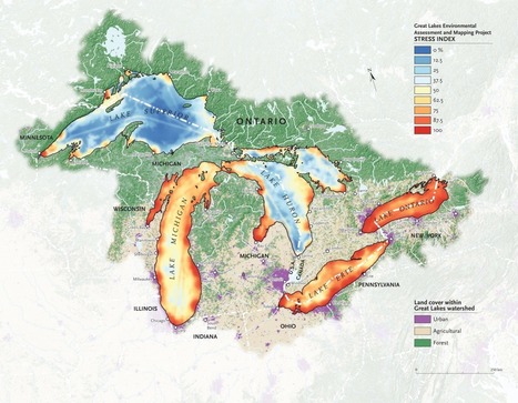
"It’s no secret that the Great Lakes are suffering tremendous ecological strain — Lake Erie was even pronounced “dead” for a time during the 1960s because of an overload of phosphorus from municipal waste. Back in 1615, though, when the entire region was pristine and explorers Samuel de Champlain and Étienne Brûlé gazed out together from Lake Huron’s shores, they dubbed it la mer douce, 'the sweet sea.' Today roughly one-quarter of Canada’s population and a 10th of America’s population drink from the Great Lakes basin; the beleaguered lakes alone hold more than a fifth of Earth’s freshwater." Via Mike Busarello's Digital Storybooks

Lou Salza's curator insight,
April 15, 2017 11:52 AM
These lakes are a tremendous resource, not only for the region but the nation as well. They need our attention and protection.-Lou 
Nicole Canova's curator insight,
February 8, 2018 9:58 PM
It is amazing, in a sad way, to see how in just four centuries these lakes have gone from "la mer douce" to "dead." This map is a reminder of the damage humans do to the environment on a daily basis, and of the importance of protecting our natural resources. Considering the fact that these lakes hold roughly one fifth of all of the fresh water on the planet and provide drinking water for millions of people in both the U.S. and Canada, we need to think about the impact we have on the world around us and how that impact can come back to bite us on the rear end.
From
pdfsb
I will once again preach to the choir, but with the hope that this will arm you with resources to use in discussions with administrators and colleagues in the fight against geographic ignorance. This article by Walter McDougall (2003 by Orbis) is worth reviewing and is a good reading assignment to start the school year. The link is to a PDF version of the article. Via Scarpaci Human Geography
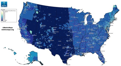
An unconventional look at American roads, mapped by their speed limits.
The above map, from MetricMaps, illustrates that abrupt division using local speed limit data. That map shows the maximum local speed limit for any local roads or highways in each Census block group in the U.S. The nationwide contrasts are striking, but so are the local ones: Zoom in to an individual city like Los Angeles, and the darker arteries effectively outline highways.

Alex Vielman's curator insight,
September 20, 2015 10:36 PM
When looking at this map, before looking at the actual index of the colors that determine the speeds, I could already tell which areas would have a higher speed level and which ones had a lower speed level. Looking at the map, the mountain region had higher speed levels. I believe this is accurate because there isn't much going on in this areas. There is tons of land and direct roads that lead to other states. These states, like Wyoming or Montana, aren't really tourist attractions. In the New England area, one could see that the speed levels are lower and I would assume it would be because there are more people in this area. There is not a lot of land here for agriculture. I would say this map seems pretty accurate. 
Raymond Dolloff's curator insight,
October 12, 2015 2:13 PM
Speeding in America can lead to some people having road rage because they are in a hurry. However, by looking at the map of speed limits in the United States, the area that would probably see less cases of road rage is in the Central and Plains states that have a speed limit of over 75 miles per hour. This will also help reduce people who speed because they are in a rush to get from point a to point b. In areas such as Rhode Island, where the speed limits reach up to 65 miles per hour, people tend to rush and get angry with people who are going below the speed limit and lead to the need for speed to calm themselves down. Thus, it also includes a higher risk for getting a speeding ticket which will be expensive.
From
vimeo
"In just a few generations, we have tightly restricted American kids' freedom to roam, play, and become self-sufficient. The percentage of children walking and bicycling to school has plummeted from almost 50 percent in 1969 to about 13 percent today. Although distance from school is often cited as the main barrier to walking and bicycling, many families still drive when schools are close to home. According to the Safe Routes to School National Partnership, driving accounts for about half of school trips between 1/4- and 1/2-mile long — which in most cases shouldn't take kids much more than 10 minutes to walk."

asli telli's curator insight,
August 15, 2015 1:34 AM
Also applies to unfortunate Turkey w/her recent urban transformation wave...

Ask any teenager for directions and he can pull up Google Maps quicker than you can recite an address. Pretty awesome, right? And I’ll be the first to admit that having a map in my phone that not only tells me where to turn but how long it will take me to get there is pretty amazing. I use it all the time, honestly. But even when I’m zoning out and listening to that soothing voice telling me where to turn, I have a mental picture in my head of her directions. And I never realized that my teenage daughter doesn’t have a map in her head, because she’s never really had to use one. Ever. Tags: education, K12, geography education, spatial, mapping.
Cade Johns's curator insight,
August 16, 2015 9:26 PM
I think maps on your phone is great but what about if you get lost and you don't have service on your phone then what are you gonna do?Most young people have never had to read an actual map so most likely they won't be able to find their way back to civilization. CJ 
Ethan Conner's curator insight,
August 17, 2015 8:56 AM
Many people cannot read maps because of technolagy. This new form of maps are keeping children from the traditional way. Also keeping them from education. 
Aaron Burnette's curator insight,
August 26, 2015 9:50 AM
Although cell phone and technology is helpful, other people still believe in the prideful way. Reading paper maps.

Let's make "10 not 12!" a new mantra for saving our cities and towns. [12 foot lanes] are wrong because of a fundamental error that underlies the practice of traffic engineering—and many other disciplines—an outright refusal to acknowledge that human behavior is impacted by its environment. Tags: transportation, planning, spatial, scale.
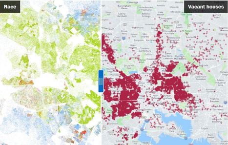
How vacant houses trace the boundaries of Baltimore's black neighborhoods. The map on the left shows one very tiny dot for each person living in Baltimore. White people are blue dots, blacks are green, Asians are red and Hispanics yellow.The map on the right shows the locations of Baltimore City's 15,928 vacant buildings. Slide between the two maps and you'll immediately notice that the wedge of white Baltimore, jutting down from the Northwest to the city center, is largely free of vacant buildings. But in the black neighborhoods on either side, empty buildings are endemic. Tags: neighborhood, gentrification, urban, place, economic, race, poverty, spatial, housing.

Lauren Quincy's curator insight,
May 24, 2015 9:14 PM
Unit 7: Cities and Urban Land Use
This article is about Sandtown, Baltimore and its shift into a disamenity sector. It explains how this neighborhood, mainly housed by blacks, had a high percentage of vacant houses. The article says that this neighborhood is overrun with poverty, war on drugs and gangs and has the more residents in jail than any other neighborhood. This shows the changing demographics of the city of Baltimore.
This relates to unit 7 because it covers the topic of disamenity sectors and changing demographics. It shows reasons for the high levels of poverty and abandoned housing. It also shows the racial spatial distribution of the neighborhood and its correlation to housing and development. 
Lydia Tsao's curator insight,
May 26, 2015 1:46 AM
This article left me heart broken. The African American community in Baltimore is stuck in a deep poverty cycle, and it cannot seem to escape its impoverished past. Even now, the poverty in the area seems to just be getting worse. The problems of income disparity lead to more problems than just economic; they lead to social and political problems. Social unrest and injustice occurs as a result of the modern white flight. This article arose as a result of the death of Freddie Gray, whose death demonstrates a significant social issue that needs to be addressed: police brutality and the criminal targeting of the African American community. His death stems from the tremendously amounts of disparity in the city. Promoting investment in the inner city would definitely help alleviate the poverty in the area. The problem is getting people to invest.
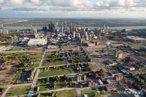
The stark contrast between the haves and have-nots is apparent from above, so too is the city’s rebound.

Dennis Swender's curator insight,
December 10, 2014 4:23 PM
A multicultural research project: by foot, by car, or by plane Select your site: Detroit? Kansas City? Feguson? New York? Take some pictures. Start observing. Interview some people. Assemble some facts. Justify your opinions.

Norka McAlister's curator insight,
February 2, 2015 5:16 PM
Deindustrialization and globalization are some of the reason why Detroit fluctuates configurations in the geography of manufacturing. The reduction of production in the car industry and all activities along with it is harmful to Detroit’s citizens, leaving a lot of workers without jobs. Globalization was adopted and American companies became attracted to the very low wages of workers in other countries that produce similar quality products as the US. Unfortunately, since globalization became the preferred option for the US, deindustrialization in Detroit rapidly increased. On the other hand, with the continuing advancements in technology, it turns out to be manageable with a few employees. Wealthy Detroiters sprawl out in the suburbs out of the city. Due to the elimination of manufacturing jobs and relocation of residents out of the state, Detroit city remains with a population of 700,000 people. The effect of deindustrialization has been devastating, not only for workers, but also for the city itself. The regions with the lowest population rate will find it hard to survive with the increase of infrastructure and less income in taxes.
"How much does size really matter? Judging by this tiny home in France, not a whole lot -- as long as the space is functional. On the seventh floor of an apartment building in Paris, there's an 86-square-foot apartment complete with a bed, kitchen, bathroom, table and chairs, closet, bathroom and storage space." --HPost

John Nieuwendyk's curator insight,
November 23, 2014 10:16 PM
With an ever-growing urban population spatial design is important in maintaining functionality, efficiency and orderliness. The apartment building in Paris is especially interesting. It is practical and functions well enough to where a person can live comfortably in a markedly small but efficient space. 
Ryann Pinnegar's curator insight,
July 6, 2015 3:02 AM
This tiny home is amazing! It is like the setting for a futuristic story.

New research suggests that map reading is a dying skill in the age of the smartphone. Perish the thought, says Rob Cowen Via Mike Busarello's Digital Storybooks

Richard Thomas's curator insight,
July 30, 2015 10:52 PM
Despite the gendered overtones of the article (that it's important for men to learn to read a map), this is some good advice, regardless of gender. The vocabulary and concepts of maps can strengthen spatial cognition and geography awareness. While GPS technology can help us in a pinch, relying primarily on a system that does not engage our navigation skills will weaken our ability to perform these functions. While it intuitively makes sense, that the 'mental muscles' would atrophy when not used, it is a reminder that an overuse of geospatial technologies can be intellectually counterproductive. So break out a trusty ol' map, but more importantly, be a part of the spatial decision-making process. Tags: mapping, spatial, technology, education. |