"A group of geologists say they've enough evidence to confirm the existence of a new continent. Writing in the journal of the Geological Society of America, the group named the eighth continent 'Zealandia.' Scientists argue for an 8th continent, Zealandia, in the Geological Society of America."
With 94% of Zealandia lying under water, most average people around the world will not care if National Geographic prints maps with an eighth continent. As cynical as that may be, geography should not be settled by human emotions and cultural expectations. Geography is a discipline that aims for understanding and precision. If continents are to be decided by continental shelves, rather than human cultural and ethnic patterns, then Eurasia is a continent and so is Zealandia. This latter outlook of focusing on physical geography is far more neutral and scientific. I would argue that is also more 'progressive'. Humans originate from one place (Africa) and are all one species. We have far more similarities than differences. Orienting our worldview to see that cultural geography is not the final arbiter of truth would ultimately bring people together. The logic follows that by acknowledging Zealandia, there is precedent for greater accuracy based on science, allowing geographers to teach about Eurasia. This is significant because it would alter the perception that Asians and Europeans are extremely distinct and separate groups due to a distorted notion that they lived on separate continents. The truth is that both groups existed on the same continent and were often brought into contact with each other throughout history. This idea, however, would further shatter the notion of a "pure, homogeneous Europe." Europe is only a "continent" because white Europeans were the first to possess the right combination of "guns, germs, and steel" to conquer other societies and elevate their own group's cultural status. Despite nature's evidence, Europeans awarded themselves an entire continent. In reality, Europe is a large peninsula of Asia. Just as Zealandia is an eighth continent sleeping underneath the waves.
This is interesting to think about. What decides what separates continents, is it geological barriers, is it culture, is it ethnic origin, or maybe even plate tectonics? Either way you look at it New Zealand makes a great case for why they could become to be considered the eighth continent. I could argue either way, to keep it simple and go by culture and geological commonalities (Oceania Islands) I would prefer it does not form its own continent. These geologist would argue otherwise.
"The largest earthquake ever recorded by instruments struck southern Chile on May 22, 1960. This 9.5 magnitude earthquake generated a tsunami that crossed the Pacific Ocean, killing as many as 2000 people in Chile and Peru, 61 people in Hilo, Hawaii, and 142 people in Japan as well as causing damage in the Marquesas Islands (Fr. Polynesia), Samoa, New Zealand, Australia, the Philippines, and in Alaska's Aleutian Islands. To see how this tsunami compares with two recent tsunamis from Chile, please watch http://youtu.be/qoxTC3vIF1U "
Tsunami ocurrido en Chile el 22 de Mayo de 1960 donde murieron 2000 personas en Chile y Perú, 61 en Hilo Hawaii, 142 en Japón causando daños en Islas Marquesas Polinesia , Samoa, Nueva Zelanda, Australia, Filipinas, Alaska's Islas Aleutianas.....enlace para ver la comparación con el Tsunamis recientes en Chile (2015)
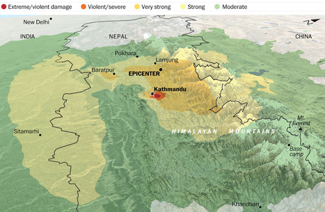
The May 12 7.3 magnitude aftershock was one of many that followed the April 25 earthquake that shook Nepal. Why is this part of the world such a hotbed of tectonic activity?
Geography determines human activity, and not the other way around; that has been the theme of this course, and it holds true as we look at the devastating impacts of earthquakes in the nation of Nepal. Sitting right over one of the most active plate boundaries in the world, with the Indian subcontinent being violently forced under the rest of Asia, Nepal is therefore the home of both the infamous Himalayan Mountains and numerous earthquakes, varying in severity and frequency. As violent and as costly as they are, violent earthquakes are just another part of life in Nepal, as are other natural events in other parts of the globe, and the people who call it home adjust their lives accordingly, through a variety of means. However, nothing can prepare anyone for the extremes of earth's power, and the violent earthquake that shook the nation to its very core in May has left behind a great deal of human suffering and destruction. I hope that those who lost their homes and businesses are already well along on their path to recovery, although I don't think it's possible to every truly heal from such a traumatic experience, at least not completely.
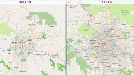
This is a great example of how using technology can benefit people. In Nepal, in which they are an area where they can get many earthquakes, they used "crisis maps" to their advantage. First off as the article state Nepal is a very difficult country to navigate and especially after the earthquake with roads being destroyed it could make it nearly impossible. With people in dire need of supplies they had to get creative. So here they used a software system called "OpenStreetMap." It is, as described in the article, a Wikipedia for mapmakers. Basically, anyone can add to the map from an amateur to a professional map maker. By allowing everyone to help they were able to make more accurate maps and faster ways to reach someone that had a need for supplies, these became the crisis maps that they would use. Going into the future this software will continue to be important in Nepal as you can constantly edit the maps and continue to find better and more efficient ways to get to place to place. Other countries with these issues should look towards Nepal and take preemptive action so that when a disaster does strike they will be ready and will not lose valuable time right after a disaster. A very interesting article in which I did not previously know much about.
"Geoscientists have unveiled a computer model that maps the details of that tectonic dance in 1-million-year increments—practically a frame-by-frame recap of geologic time. It shows that the plates speed up, slow down, and move around in unexpectedly short bursts of activity. It also suggests that researchers may have to rethink what drives much of that incessant motion. The new model shows that although plates usually creep along at an average speed of about 4 centimeters per year, some can reach much faster speeds in short sprints. For example, India, which broke off the east coast of Africa about 120 million years and is now plowing into Asia, reached speeds as high as 20 centimeters per year for a relatively brief 10 million years."
"Los geocientíficos han dado a conocer un modelo de computadora que asigna los detalles de esa danza tectónico en 1 millón de años incrementos de una recapitulación fotograma a fotograma de tiempo geológico. Esto demuestra que las placas aceleran, frenan, y se mueven alrededor de pequeños estallidos de actividad. también sugiere que los investigadores pueden tener que repensar lo que impulsa gran parte de ese movimiento incesante. El nuevo modelo muestra que, aunque por lo general se arrastran a lo largo de las placas a una velocidad media de unos 4 centímetros por año, algunos pueden alcanzar velocidades mucho más rápidas en carreras cortas. Por ejemplo, la India, que estalló frente a la costa oriental de África a unos 120 millones de años y ahora está arando en Asia, alcanza velocidades de hasta 20 centímetros por año durante un tiempo relativamente breves 10 millones años ".
The eruption of a “supervolcano” hundreds of times more powerful than conventional volcanoes – with the potential to wipe out civilisation as we know it – is more likely than previously thought, a study has found.
"The signs that something’s wrong are not immediately obvious, but, once you see them, it’s hard to tune them out. Curbs at nearly the exact same spot on opposite sides of the street are popped out of alignment. Houses too young to show this kind of wear stand oddly warped, torqued out of sync with their own foundations, their once-strong frames off-kilter. This is Hollister, California, a town being broken in two slowly, relentlessly, and in real time by an effect known as 'fault creep.' A slow, surreal tide of deformation has appeared throughout the city."
When the giant fault line along the Pacific Northwest ruptures, it could be our worst natural disaster ever.
The Cascadia subduction zone remained hidden from us for so long because we could not see deep enough into the past. It poses a danger to us today because we have not thought deeply enough about the future. The Cascadia situation, a calamity in its own right, is also a parable for this age of ecological reckoning, and the questions it raises are ones that we all now face. How should a society respond to a looming crisis of uncertain timing but of catastrophic proportions? How can it begin to right itself when its entire infrastructure and culture developed in a way that leaves it profoundly vulnerable to natural disaster?
Thanks to advancements in technology and dedicated researchers who often forgo glory and fame, Americans are now aware of another impending natural disaster that is likely to ruin the lives of so many of our fellow citizens. This article reminded me of the impending doom of climate change and the resulting ecocide. So many of us, even people who put faith in religion, trust scientific discovery enough to acknowledge that these are realities we face as a society. Not all of us are totally brainwashed to dismiss this a secular, liberal hoax. Despite this awareness, not much - if anything - is being done to address or prepare for the awaiting earthquake and tsunami. This fact affirms that the United States' population is largely out-of-touch with reality. In a fantasy world, like ours, we are too special and superior (perhaps chosen by destiny or God) to suffer such a drastic and radically dreadful experience of nature. The delusion prevents us from acting sooner, rather than later. What comes to mind is the Netherlands as they train their population and renovate their urban centers to flow with the tides of climate change. They have the knowledge (like we do) but the difference is they have embraced it and in a communal way have decided to take action. These Europeans are adapting to their situation. This sheds light on the irony of the United States; a powerful, resource rich, skilled, and highly capable country that is falling a part because of what? Greed for wealth? Selfishness? Dare-I-say foolishness? Maybe it is indifference in an age of modernity - devoid of true human connection but full of technological bliss and distraction? Add the Cascadia subduction zone to modernity's doom list now including unsustainable wealth inequality, overextended military policies, climate change complacency/denial, mass incarceration, obesity, mass shootings, a post-fact world, and an Opioid health epidemic. These are BIG problems that need bold strokes. Simply put, many people with wealth and power do not feel a connection to their countrymen and countrywomen to allow a government - acting on behalf of the masses - to do something. And, that is a key link. Businesses seeking to make a profit do not want regulations and adaptation to interfere. The cost of addressing these problems is a potential loss of money-making as consumers modify their behavior and new policies require more funding through taxes.
As this article relates to geography and my aforementioned class-warfare rant: the Earth is indisputably a complex planetary system that has always been totally indifferent to human wants and needs. The planet has no obligation or will to act in our best human interests. We, as a people, must respond to the planet. When it shakes, we must brace or move. In other words, we must take action or experience the consequences of inaction. Crony capitalism, excessive wealth, and a government held hostage by corporate interests which prioritize profit over people are serious hurtles. The wealthy and powerful should realize that they need US - the 90% of people that lack significant amounts of disposable income. 90% is a large chunk of civilization! There is no wealth and prosperity if there is no healthy civilization on which to build a business or exercise entrepreneurial abilities. It is time to confront greed by recognizing our collective humanity - a humanity shaped and informed by geographically determined experiences.
An insightful and honestly, scary article. Discussing the inevitable earthquake that would devastate the pacific northwest, but not knowing when it could occur makes me never want to even visit. The Cascadia earthquake which could or more likely would send a tsunami straight into Oregon. Learning from the Seaside, Oregon superintendent that three of the four schools under his charge will go from five to fifteen feet above sea level to as much as forty-five below would shake anyone to their core. So what has the state done to remedy this? Nothing, unfortunately. With no Early-warning system, he describes how one elementary school will be trapped, as they will have no escape. With the growing ocean waters on one side and a roadless bog on the other, these students have nowhere safe to go. This reminds me of the question, would you rather know how you will die or when you will die? Waiting with no clue when the impending doom will occur until it happens is too much for me. I recommend get out now and get out quick unless the state figures out a warning system, then just get out quick.
Yes, we have some serious earthquakes on the San Andres fault and in Japan but we're overlooking the one along the Pacific Northwest. An out roar has to be made for people to be more notified of the Cascadia subduction zone, so people can prepare for tragedy. We need to realize that the way these plates move can make a major ripple effect on our way of life.
This animation is made from a time series of maps reconstructing the movements of continental crust or blocks, as South America pulled away from North America, starting 170 million years ago. Note that South America is still clinging to Africa at the beginning of the series.
The animation in this video depicts how Central America and the Caribbean’s landforms came to be. What is interesting is that about 170 million years ago, Africa and South America were part of the same land mass and today Africa is pretty far away from South America. This means that there are probably similar geographic features on the two continents, like rocks or soil, despite the distance between them now. That may contribute to people being able to grow similar crops in the two areas that are oftentimes seen as so different. The western part of South America, specifically Central America seems to have been pulled apart from North America. This means that these two continents may share geographic features as well. Although regions may seem like they are separated by great lengths and should be dissimilar from each other, that is not the case- as the tectonic plates are constantly shifting the way the earth’s surface looks. It’s hard to think that the earth was ever different than it is today and how such large land masses could possibly move so far. This animation does a good job of exemplifying the great effect that tectonic plates actually have.
It's interesting to see how the earth's surface has changed over time. It's also strange to see that at one point the Americas were so compact, and that Africa was attached to both North and South America. Although these tectonic shifts take place over the course of millions of years, this video makes me wonder what the globe will look like in another million years, or another 100 million years. I'm sure the continents will be in a new configuration as unrecognizable as they were 170 million years ago.
It is fascinating to see how South and Central America has formed into what we know today. A nice view of what was once attached to Africa is now a distant past and can still see some similarities. It's nice to see how our world today was formed million of years ago.
"This video is from the BBC documentary film Earth: The Power Of The Planet. The clip is also embedded in this story map that tells the tale of Earth’s tectonic plates, their secret conspiracies, awe-inspiring exhibitions and subtle impacts on the maps and geospatial information we so often take for granted as unambiguous."
"The magnitude-7.8 earthquake that struck Nepal on Saturday morning destroyed parts of Kathmandu, trapped many people under rubble and killed more than 2,500 people. It was the worst to hit the country since a massive 1934 temblor killed more than 8,000."
It's absolutely devastating what happened to Nepal. Any loss of life is a tragedy but loss of this scale is unimaginable. It's going to be a difficult rebuilding process for the Nepalese whether that's coping with the loss or physically rebuilding the nation.
Watching footage of shakes, what struck me the most was hundreds of year old temples crumbling. Those just aren't something you can easily rebuild. The building can eventually be replaced but the significance of it is almost lost.
Those temples, like the homes in the area, were most likely not built up to a standard that could withstand earthquakes or at least earthquakes of this magnitude. It's easy to see how destruction on this scale can occur in large urban populations that were not designed to stand against such a dramatic event.
I've experienced earthquakes more times than I've ever felt the need. We used to get them all the time it seemed in Japan. My bed would role across the room. It got to the point where I just slept through them. If I had even felt a shake half as violent as what Nepal went through I could not even imagine the fright. I wonder how long the India and Eurasia tectonic plates will stay on top of each other? Or if a few more earth quakes will split the area?
We have learned that the Himalayas are growing everyday while our Appalachians in the united states are shrinking. What does this all mean? In the platonic spectrum it means in Nepal, earthquakes.
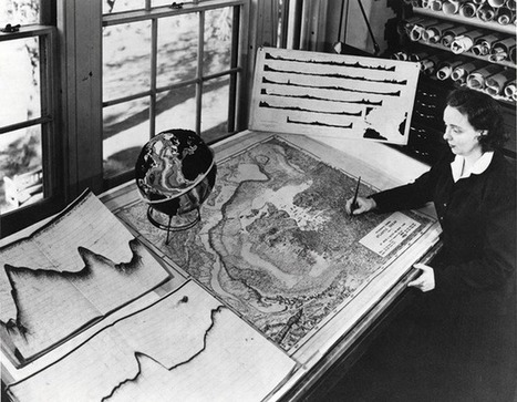
Without ever setting sail, Marie Tharp mapped the ocean floor and made a discovery that shook the foundations of geology. So why did the giants of her field dismiss her findings as “girl talk"?
To get content containing either thought or leadership enter:
To get content containing both thought and leadership enter:
To get content containing the expression thought leadership enter:
You can enter several keywords and you can refine them whenever you want. Our suggestion engine uses more signals but entering a few keywords here will rapidly give you great content to curate.


 Your new post is loading...