Astronauts on the International Space Station took these images of cities at night. Note that up doesn’t necessarily mean north. All images: ESA/NASA
Via LEONARDO WILD, Mike Busarello's Digital Storybooks
Get Started for FREE
Sign up with Facebook Sign up with X
I don't have a Facebook or a X account


 Your new post is loading...
 Your new post is loading...
Your new post is loading...
Astronauts on the International Space Station took these images of cities at night. Note that up doesn’t necessarily mean north. All images: ESA/NASA Via LEONARDO WILD, Mike Busarello's Digital Storybooks 

Ivan Ius's curator insight,
March 28, 2017 8:44 AM
Geographic Thinking Concepts: Spatial Significance, Patterns and Trends

Alexander peters's curator insight,
April 11, 2017 9:07 AM
The article was about identifying city lights from the sky. I think that it was fun to do and guess them.
Sign up to comment

Amazement sets in when we see images of the past depicting the future, especially when some of the ideas aren't too far off the mark. A set of 19th century postcards has revealed what French artists thought would be happening at the turn of the 21st century. The set of postcards, produced between 1899 and 1910, predict what life might be like in Paris in the year 2000. The year 2000 may now be history (hard to believe it has already been 14 years since the initial celebration of the new millennium) but stepping back in time is always fascinating. There are some fairly bizarre scenes that have not come to fruition—no one has yet invented a flying fireman, or started playing croquet underwater—but whose to say they are not on someone's drawing board somewhere. Via Sharla Shults

"Move forward 148 years from the War of 1812 to the year 1960. Via Sharla Shults
The average person's geography skills are fairly poor beyond their region. Test your knowledge of the countries at HowStuffWorks. Via Mike Busarello's Digital Storybooks

We’ve stripped out the street names and lost the labels – but can you still recognise the cities from their aerial views? Via Mike Busarello's Digital Storybooks
A weekly show where knowledge junkies get their fix of trivia-tastic information. This week, John shares 27 facts about maps.

Ashley Burleson's curator insight,
August 11, 2015 4:45 AM
This Mental Floss video is an entertaining rapid-fire hodgepodge of map trivia with some important educational content nicely nestled in there. This 99 Percent Invisible podcast is another 'ode to maps,' but this one is more poetic about the value of cartography and personal in how it explores the qualities they possess. Enjoy them both! Tags: mapping, trivia, cartography. 
Matt Davidson's curator insight,
August 11, 2015 7:43 AM
Maps are awesome - need I say more! This clip actually covers a significant amount on the power / influence of maps through history. 
Ruth Reynolds's curator insight,
August 11, 2015 7:59 PM
Very USA centric but entertaining and makes you think about the taken-for- granted use of maps. We do believe them!!

Jared Medeiros's curator insight,
February 18, 2015 5:49 PM
An absolutely great and fun way to learn and explore different geographic locations. Anytime learning can be made fun or turned into a game is always a win-win. I found myself screwing around with these mini games and before I knew it, 45 minutes had passed, and I was not as good at Geography as I thought I was. I will be back to play/learn more! 
Lena Minassian's curator insight,
February 18, 2015 6:59 PM
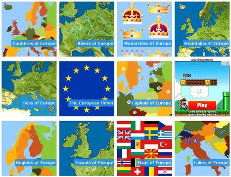
This is an interesting way to learn geography in a more interactive way. This link provides many different games that allow you to not only play a game but learn while you do it! These games can test capitals, rivers, monarchies, countries, regions, peninsulas, battles, etc. All of these relate to Europe and can provide different learning techniques for anyone who is interested in them. 
Kevin Nguyen's curator insight,
December 7, 2015 12:05 PM
This Toporopa is a great interaction games for people who are interested in geography. Europe has a rich history dates back to colonial times and there are many interesting facts that a lot of people does not know about it. It is fun and entertaining way to train your brain and a great review to see what you know about the world.

Smarty Pins is a Google Maps based geography and trivia game.

flea palmer's curator insight,
July 7, 2014 10:33 AM
This is really good fun - I got gold (14/15) not sure how many miles though! 
Tom Franta's curator insight,
July 10, 2014 9:54 AM
An interesting way to get anyone interacting with Google Maps...
Trivia quiz questions on Pop Music, Movies, Geography, Science, Computers, Literature and Classical Music
The world's largest and most popular trivia website with over one million trivia questions and quizzes.
|
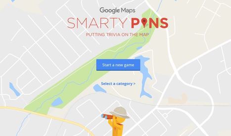
Smarty Pins is a Google Maps based geography and trivia game. Via Mike Busarello's Digital Storybooks

Yes! Life IS music. It is all around us in everything we do. We may not deem it 'music' at the time but listen closely enough and the surrounding sounds will become melodic in their own way. Perception, interpretation and motivation join hands as thoughts revolve around the harmonies of everyday life. Observe life at its best, listen to life’s songs, embrace life’s bounties, breathe the breath of life and savor life to its fullest! See your life in terms of music. Via Sharla Shults

Today's History Lesson...ice cream cone Via Sharla Shults

Think you're a geography expert? Test your knowledge with BBC Travel’s Geoguessr – the game that proves how well you know the world!
Skuuppilehdet's insight:
I've shared GeoGuessr before but they now have country-specific quizzes (this is for the United States). When I was a child I used to wonder if woke up somewhere far from home, would I be able to know where I was just by looking at the places around me (I was a geo-geek from way back when). GeoGuessr is the closest thing to finding yourself lost in the world and needing to figure out where you are without being wisked away. GeoGuessr will display 5 locations in GoogleMaps "StreetView" and you have to guess where the images are located. You can pan and zoom in the StreetView to explore the landscape and find more context clues as to where that location is. It is a fantastic exploration exercise.

Lilydale High School's curator insight,
March 29, 2016 5:37 PM
I've shared GeoGuessr before but they now have country-specific quizzes (this is for the United States). When I was a child I used to wonder if woke up somewhere far from home, would I be able to know where I was just by looking at the places around me (I was a geo-geek from way back when). GeoGuessr is the closest thing to finding yourself lost in the world and needing to figure out where you are without being wisked away. GeoGuessr will display 5 locations in GoogleMaps "StreetView" and you have to guess where the images are located. You can pan and zoom in the StreetView to explore the landscape and find more context clues as to where that location is. It is a fantastic exploration exercise.
Tags: landscape, place, trivia. 
MsPerry's curator insight,
March 31, 2016 12:58 PM
I've shared GeoGuessr before but they now have country-specific quizzes (this is for the United States). When I was a child I used to wonder if woke up somewhere far from home, would I be able to know where I was just by looking at the places around me (I was a geo-geek from way back when). GeoGuessr is the closest thing to finding yourself lost in the world and needing to figure out where you are without being wisked away. GeoGuessr will display 5 locations in GoogleMaps "StreetView" and you have to guess where the images are located. You can pan and zoom in the StreetView to explore the landscape and find more context clues as to where that location is. It is a fantastic exploration exercise.
Tags: landscape, place, trivia.

We hear the names of these places in the news constantly, but can you actually locate them on a map? Via Mike Busarello's Digital Storybooks

Courtney Barrowman's curator insight,
August 24, 2015 2:10 PM
locational geography test your knowledge and challenge yourself!

"Here’s a winning question for your next trivia night: Where is the world’s largest island-in-a-lake-on-an-island-in-a-lake-on-an-island? According to stories published here and here, the distinction currently goes to a nameless isle within Victoria Island in Canada’s Nunavut Territory. On August 21, 2014, the Operational Land Imager (OLI) on Landsat 8 captured this natural-color view of the “sub-sub-sub-island.” The top image shows a close-up view of the unnamed island, while the bottom image shows a wider view of Victoria Island’s lake-littered landscape (download large image here)."
Tags: Canada, trivia, remote sensing, geospatial. Via Mike Busarello's Digital Storybooks


Gabriel Olson's curator insight,
February 13, 2015 2:59 PM
We ought to know something about where our food comes from... 
Eden Eaves's curator insight,
March 24, 2015 1:04 AM
Unit 5 Some of these maps are easy to guess, such as cotton being grown in the south, but what about others like pigs being raised in the mid-west and North Carolina??? We are so used to having only to make a quick stop at the nearest grocery store to grab our weekly essentials that we don't always think about where it naturally comes from. Also preservatives have come so far as to keep things fresh for long periods of time that where it originates is not a problem because it can be shipped in a refrigerated truck with still time left for it to sit in your fridge for a few days. 
BrianCaldwell7's curator insight,
March 16, 2016 3:34 PM
This 12 question quiz is a great way to introduce students to spatial patterns of agricultural products in the United States. Sometimes just knowing regional stereotypes can be helpful, but being able to make an educated guess about where an agricultural product is comes from requires a basic understanding of economic and climate patterns. This quiz is a good way to test that knowledge and introduce them to these spatial patterns.
Tags: trivia, spatial, regions, food, economic, food production, agriculture.
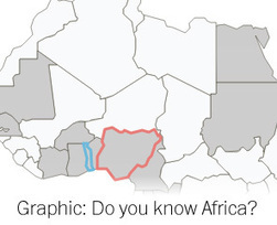
Many of Africa’s leaders will be in town next week attending a White House summit. The continent’s land is shared among 49 countries — many of which rarely make U.S. headlines. How familiar are you with Africa’s geography?
Jared Medeiros's curator insight,
March 29, 2015 5:21 PM
I love interactive maps like this. These are the best way to learn where things are in the world geographically. Africa is the toughest, for myself, continent in the world to be able to locate and identify where certain countries are. This is in part because Africa has so many countries and also Africa is a part of the world that is not often taught in school, therefore you have limited thoughts and ideas about these types of areas. 
David Lizotte's curator insight,
April 22, 2015 1:54 PM
I have always been fascinated with Africa and its history. Through its history one can understand why Africa is the way it is today. Its a shame that Africa does not have more of a focus in the Public School Curriculum. Its played a huge part in developing western civilization, whether it be in ancient Alexandria providing grain for the Roman Republic or the coltan extracted through inhumane means in the Democratic Republic of the Congo. Africa is a continent that has been raped and torn in a repetitive manor under a variety of foul experiences brought upon by western countries. These are the same western countries that are held of high interest and regards in subject manor instituted in the Public School System. Africa has also been apart of amazing developments of human civilization, for example the Trans Saharan Trade Route which linked Kingdoms such as Ancient Ghana to dynasties far in the Middle East. It is also the birthplace of man (no big deal). In either case there needs to be a stronger push on teaching/molding "Africa" (yes, I know... broad) into the curriculum. It is important in both understanding the history of the world, specifically western civilization and how it coined itself “civilized.” Through introducing basic aspects, history, and dilemmas (both old and modern) it could inspire more interest and an expansion of knowledge from student to student. School is and will most likely continue to be Euro-centric and have large flares of Americana and other “themes” of North America. 
Taylor Doonan's curator insight,
March 24, 2018 5:31 PM
This interactive map quizzes you on the location of the states of Africa and it shows the percentage of how many people found certain countries. South Africa, Madagascar and other more recognizable countries had higher percentages, but it is still a difficult quiz as many people do not know the geography of Africa.

Fun trivia quiz games from Triviala. Play a wide range of trivia quizzes online for free with the chance to win prizes, and make new friends while you play.
|