Human Interest
199.0K views | +0 today
Follow
Human Interest
Your new post is loading...
Scooped by Skuuppilehdet
Scoop.it!

What are El Niño and La Niña?

What are El Niño and La Niña? | Human Interest | Scoop.it

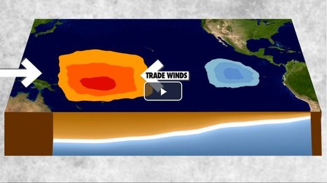
"El Niño and La Niña are complex weather patterns resulting from variations in ocean temperatures in the Equatorial Pacific--officially known as the El Niño-Southern Oscillation (ENSO) cycle. These deviations from normal surface temperatures can have large-scale impacts not only on ocean processes, but also on global weather and climate."

ROCAFORT's curator insight, February 24, 2017 2:31 AM
What are El Niño and La Niña?
Loreto Vargas's curator insight, February 24, 2017 12:45 PM
It’s a complicated phenomenon but El Niño is not the same as La Niña... Read the article.
Scooped by Skuuppilehdet
Scoop.it!

Clinton would have won if the United States looked like the top map

Clinton would have won if the United States looked like the top map | Human Interest | Scoop.it
Can you tell what’s wrong with this map of the United States? I’ll give you a hint: Look near the Great Lakes and the Gulf of Mexico. Spot the problem yet? A further hint: Look at the border of Wisconsin and Illinois as well as the Florida Panhandle. See it now? The Wisconsin-Illinois border is slightly more southern and the Florida Panhandle is slightly shorter.
Corey Rogers's curator insight, December 13, 2018 4:14 PM
The electoral college is such a mess that it shouldn't be relied on for figuring out the President. With the misrepresentation of the map and the continuous gerrymandering the United States should use the popular vote category instead of the Electoral College. 
Scooped by Skuuppilehdet
Scoop.it!

Topography of Religion

Topography of Religion | Human Interest | Scoop.it

"The Pew survey sorts people into major groupings--Christians; other religions, including Jewish and Muslim; and 'unaffiliated,' which includes atheist, agnostic and 'nothing in particular.'  Roll your cursor over the map to see how faiths and traditions break down by state."

Ignacio Quintana's curator insight, December 1, 2014 6:56 PM

Even though this is just an info-graphic, this is very interesting. What we can see from this map is the spatial organization of religion specifically in the U.S. It's interesting to see how protestant makes up the majority (but apparently not according to the article above this from Haak's page) and how drastically these views can change from coast to coast, and state to state. What I find particularly interesting is that you can clearly find hearths of many of these religions, for example, Utah has an extremely out-numbering amount of Mormons. For obvious reasons that is, but still very educational to see the centers of many of the big religions in the United States.

Joshua Mason's curator insight, January 28, 2015 8:46 PM

Looking at the map, it looks like the Northeast is predominately Catholic while the further South you go along the Eastern coast, you find more Protestants, mostly Evangelical, especially in the from Confederate States. The Mid and Northwest seems to hold a healthy mix of all the Christian denominations while places in the Southwest have a higher Catholic percentage, my guess would be from immigration from Mexico. The one odd ball out in the Southwest is Utah with its 58% of Mormons.

Molly McComb's curator insight, March 21, 2015 4:04 PM

Different cultural religions and senses of place in America. This graph shows the diversity of religion around the united states as it varies from place to place. 

Scooped by Skuuppilehdet
Scoop.it!

America's 'Megaregions' using Commuter Data

America's 'Megaregions' using Commuter Data | Human Interest | Scoop.it
New maps use math to define the amorphous term.
PIRatE Lab's curator insight, December 10, 2016 10:30 AM
Another example is the long line of defining the new geography.
Boris Limpopo's curator insight, December 11, 2016 1:43 AM
Le macroregioni americane con i dati del pendolarismo
Tom Cockburn's curator insight, December 13, 2016 3:53 AM
Plenty of space in the middle it seems
Scooped by Skuuppilehdet
Scoop.it!

The United States' Geographic Situation

The Greater Mississippi Basin is the United States' core and serves as the underpinning of its role as a global superpower. For more analysis, visit: http://...
Adrian Bahan (MNPS)'s curator insight, April 20, 2015 8:51 PM

Think about the units and topics  we've covered this year. Migration, urbanization, development, and geo-political theories. Use examples from all of the above to justify the statement that the geography of the United States is responsible for its role as a global superpower.

Kevin Nguyen's curator insight, September 21, 2015 12:14 PM

This video contains a nice overview of the United States' geography. This bi-coastal country has the ability to access to a wide variety of trades from Europe and Asia. Along with the self-sufficient interior breadbasket region and coastline, it explains why U.S became such a major superpower in the 20th century. Understanding United States geography is an important skill to know when studying History. As a student of History I find this video very informative. 

Adam Deneault's curator insight, December 4, 2015 8:30 PM
I personally do not agree with the name "The United States' Geographical challenge," because to me is seems as if geographically we have a great set up, as the video said we are insulated by two oceans with naturally indented deep harbors and because of the Mississippi River Basin, we have the naturally interconnected system that allows us transport goods for cheap and to supply itself efficiently. it also nice to know that because of our advantages, we have what other countries do not and have a protection with the help of our Navy.