Human Interest
199.1K views | +8 today
Follow
Human Interest
Your new post is loading...
Scooped by Skuuppilehdet
Scoop.it!

Petra, Jordan: Huge monument found 'hiding in plain sight'

Petra, Jordan: Huge monument found 'hiding in plain sight' | Human Interest | Scoop.it

"Two archaeologists, who recently published their findings in the American Schools of Oriental Research, used Google Earth satellite images and drone photography to identify the outline of an enormous monument buried beneath sand and time at the UNESCO World Heritage site in Jordan."  --Motherboard

Zavier Lineberger's curator insight, March 29, 2018 3:38 PM
(Middle East) Using modern technology, archaeologists have discovered a new monument hidden underground in Petra. The find, dated around 150 B.C., is thought to be a ceremonial site with two platforms, pottery. columns, and a staircase carved out of stone. It is amazing that there are still new finds like this in the 21st century, but the history of the Middle East is so incredibly old, with so many extinct civilizations, that archaeologists will probably keep making new breakthroughs.
brielle blais's curator insight, April 1, 2018 4:40 PM
Physical geography can be really cool as understanding the current land helps to also understand the past. Researchers finding new monuments like this in Petra shows the importance of knowing the land around you, or someplace important like where the UNESCO World Heritage Site. 
Laurie Ruggiero's curator insight, May 29, 2018 5:30 PM
Unit 1
Scooped by Skuuppilehdet
Scoop.it!

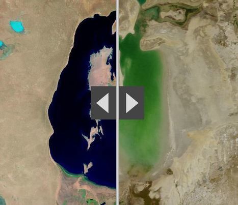
Human activities are reshaping Earth's surface

Human activities are reshaping Earth's surface | Human Interest | Scoop.it

"By moving the slider, the user can compare 1990 false-color Landsat views (left) with recent true-color imagery (right). Humans are increasingly transforming Earth’s surface—through direct activities such as farming, mining, and building, and indirectly by altering its climate."

James Piccolino's curator insight, March 24, 2018 9:46 AM
Wow. This is depressing. I knew of the Aral sea thanks to class, but the others I had no idea. They were so green and lush way back in the day. Now they are dead and seriously in a sad state. There is nothing wrong with development and advancement, but this is just a lot when it comes to impact.
othni lindor's curator insight, October 20, 2018 4:01 AM
This map shows how human activities like farming has shaped the Earth's surface. The example they show is the Aral Sea. It is a 
regional environmental problem. It is located between the Southern part of Kazakhstan and Northern Uzbekistan. It used to be the world's fourth largest saline lake. Human activities have caused the lake to be almost completely dried up. Over the years, the Aral Sea became polluted with pesticides and chemicals. 


Stevie-Rae Wood's curator insight, October 28, 2018 9:51 PM
The Aral Sea is a severe environmental issue in Central Asia. This map that we are looking at shows how human activities such as farming have destroyed a natural wonder. The Aral Sea USED to be the fourth largest saline lake but has dried up. The Aral Sea has five times less volume and is five times more saltier than it once was. This occurred because people surrounding the area used more water and used it more intensely. The soviets thought it would be a good idea to use more water projects such as planting cotton, and rice which are water intense crops. This severely dried up the Sea. The area that the sea once was that is now dry land in uninhabitable because of the levels of salt left behind. As well the rivers that connected to the Aral Sea have either dried out or are on the verge of drying out causing many economic problems for those that depended on that water.
Scooped by Skuuppilehdet
Scoop.it!

15 before-and-after images that show how we're transforming the planet

15 before-and-after images that show how we're transforming the planet | Human Interest | Scoop.it
We've dammed mighty rivers, built hundreds of artificial islands, and made the world's fourth-largest lake disappear.
Courtney Barrowman's curator insight, May 21, 2015 10:02 AM

Summer reading KQ2, How have humans altered Earth's environment? key concepts- remote sensing, land use

Gregory Stewart's curator insight, August 29, 2015 9:32 AM

Spatial Perspective!

Rescooped by Skuuppilehdet from AP HUMAN GEOGRAPHY DIGITAL STUDY: MIKE BUSARELLO
Scoop.it!

A Landsat Flyby

"The Landsat program is the longest continuous global record of the Earth's surface, and continues to deliver both visually stunning and scientifically valuable images of our planet. This short video (download here) highlights Landsat's many benefits to society."


Tags: remote sensing, geospatial, unit 1 GeoPrinciples.


Via Mike Busarello's Digital Storybooks
Stephen Zimmett's curator insight, October 13, 2014 1:00 PM

another great bit of info from Seth

GTANSW & ACT's curator insight, October 19, 2014 7:34 PM

Environmental change at a variety of scales 

Rescooped by Skuuppilehdet from Geography for All!
Scoop.it!

Changes in Three Gorges Dam

NASA's animation of China's Three Gorges Dam construction over the years.

Via Trisha Klancar
Benjamin Jackson's curator insight, November 9, 2015 5:40 PM

The impact of the Three Gorges Dam on the residents upstream is amazing. I cannot imagine anything like this happening in the US, mostly because of the impact on the people both upstream and downstream. Ecological damage from this dam may not phase the Chinese government, but I think any North American or European government would shudder at the thought of the backlash among their citizens this would create.

Matt Ramsdell's curator insight, December 14, 2015 9:27 PM

Three Gorges damn in China is the largest dam ever constructed. This was created to save on power by creating hydroelectric power for the people of the land. One of the issues with this was the the flooding of the land up streams displacing millions of people. It created a larger up stream area and very small down stream. A lot of the people that lived up stream had to be relocated further inland and faced changing climatif weather. The banks of the river are carved out between what seems like mountainous regions so as you move more uphill the weather and temperature will be a whole new category of life (Depending on how far you relocated).

Stevie-Rae Wood's curator insight, December 9, 2018 6:09 PM
From the animation that NASA has created of the construction of the Three Gorges Dam it is apparent that land has been lost. The Three Gorges Dam was created to generate more energy for Chinas growing economy. It is known as the largest hydroelectric project ever costing around 40 billion dollars and requiring 20,000 workers. There is a good and bad side to the creation of this dam. It has helped Chinas economy grow however to the expense of the people that were displaced because the dam took away land as we can see In the animation. It also effected people downstream negatively as we can see as well because there water supply was depleted. Like most things that take place today the people that benefit from something usually live far away from the problem while those that live closest pay the more costly price.
Scooped by Skuuppilehdet
Scoop.it!

The Drying of Lake Urmia

The Drying of Lake Urmia | Human Interest | Scoop.it

"Lake Urmia in northwestern Iran was once one of the largest saltwater lakes in the Middle East, but it has diminished dramatically. Diversion of water from local rivers for agricultural use is one likely cause. Since 1996, drought has further contributed to the decline. The lake now covers about 10 percent of the area it covered in the 1970s. In the 2014 image, the entire southern portion of the salty lakebed is exposed. Also see this set of images."


Tags: Iran, remote sensing, geospatial, unit 1 Geoprinciplesland use, foodfood production, environment.

No comment yet.
Scooped by Skuuppilehdet
Scoop.it!

Earth From the ISS

"Watch along with Expedition 38 crew members Mike Hopkins and Rick Mastracchio as they look at various cities across the globe from the vantage point of the cupola on board the International Space Station."  


Tags: mapping, perspective, images, remote sensing, geospatial, unit 1 Geoprinciples.

No comment yet.
Scooped by Skuuppilehdet
Scoop.it!

What Does Earth Look Like?

Courtney Barrowman's curator insight, August 27, 2014 12:37 PM

Unit 1

MsPerry's curator insight, September 1, 2014 9:51 AM

APHG-Unit 1

Alex Smiga's curator insight, September 7, 2015 4:29 PM
Seth Dixon's insight:

This video covers various topics important to mapping and satellite imagery (and alesson from an APHG teacher on how to use this video with other resources).  There is so much more to the world and space than what we can see see.  Chromoscope, referenced in the video, simulates other forms of energy on the electromagnetic spectrum besides just visible light.  This type of information is at the core of the science behind all of our satellite imagery.  This video also covers many map projection issues and highlights online resources to understand map distortion including:

Google’s Mercator Map PuzzleJason Davies’ interactive map projection websiteInteractive Gnomonic Projectionand the military's live rendering of what the Earth looks like right now.