 Your new post is loading...
In the 1860s and 70s, photographer Timothy O'Sullivan created some of the best-known images in American History. After covering the U.S. Civil War, (many of his photos appear in this earlier series), O'Sullivan joined a number of expeditions organized by the federal government to help document the new frontiers in the American West. The teams were composed of soldiers, scientists, artists, and photographers, and tasked with discovering the best ways to take advantage of the region's untapped natural resources. O'Sullivan brought an amazing eye and work ethic, composing photographs that evoked the vastness of the West. He also documented the Native American population as well as the pioneers who were already altering the landscape. Above all, O'Sullivan captured -- for the first time on film -- the natural beauty of the American West in a way that would later influence Ansel Adams and thousands more photographers to come. Tags: images, art, landscape, tourism, historical, USA.
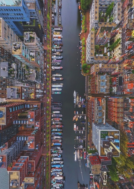
"Nature and humankind are both great artists, and when they join forces, amazing masterpieces can be produced. Today Bright Side has collected for you works in which the combined efforts of mother nature and photographic artists have captured magic moments showing the wondrous diversity of modern life and the natural world. Pictured above is the Westerdok District in Amsterdam." Tags: images, art, landscape, worldwide.
Via Suvi Salo
Can you guess where we are taking you today? Here's a clue: This city's name translates to "where the river narrows."
Via Ben Salve
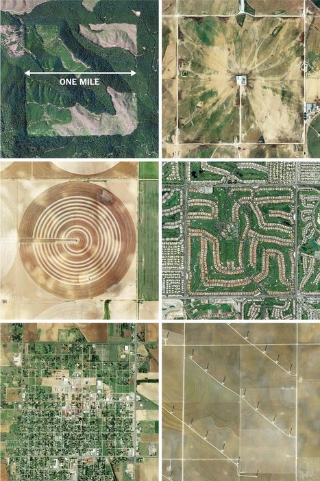
"The images here, taken from the Instagram account @the.jefferson.grid show just a few of the landscapes that can be squeezed into the one-mile squares. The idea behind this sprawling checkerboard emerged after the Revolutionary War. As the United States expanded westward, the country needed a systematic way to divide its newly acquired lands. The original colonies were surveyed using the British system of 'metes and bounds,' with parcels delineated using local geography. That approach doesn’t scale very well, and Jefferson proposed to slice the young United States into gridded plots of land. Jefferson's idea became a reality in 1785 when it was enacted as the Public Land Survey System. Today his grid covers much of the country, and it is still used to survey federal lands — an idea that shaped the physical landscape of half a continent." Tags: images, land use, landscape, social media, planning, spatial, scale, historical.
Via Mike Busarello's Digital Storybooks
"Aerial photo tour across countries and continents with a French photographer Yann Arthus-Bertrand"
Via Dawn Haas Tache
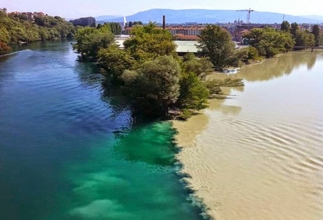
"Confluences occur wherever two streams come together. If the gradient is low (i.e., nearly level) and the properties of the two streams are very different, the confluences may be characterized by a dramatic visible distinction as the mixing occurs only slowly."
Tags: physical, fluvial, geomorphology, erosion, landscape.
In this image-filled talk, Yann Arthus-Bertrand displays his three most recent projects on humanity and our habitat -- stunning aerial photographs in his series "The Earth From Above," personal interviews from around the globe featured in his web project "6 billion Others," and his soon-to-be-released movie, "Home," which documents human impact on the environment through breathtaking video.
|
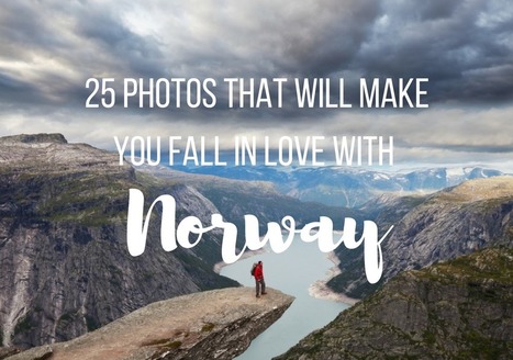
"So how gorgeous is Norway? From its majestic wildlife, captivating Northern Lights shows, and snowy mountains, to its vivid landscapes, and mystifying fjords, Norway is a must-visit destination for anyone who loves the outdoors. Plus, opportunities for hiking, kayaking, glacier climbing, fishing, and skiing are endless! If Noway wasn’t already on your travel bucket list, I bet it is now!"
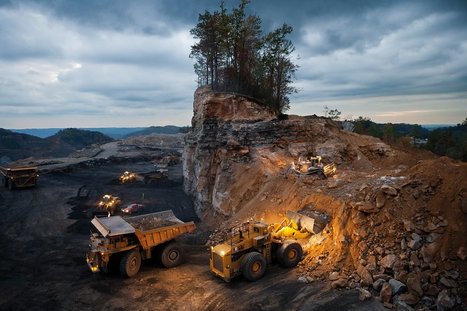
Environmental artist J Henry Fair captures the beauty and destruction of industrial sites to illustrate the hidden impacts of the things we buy – the polluted air, destroyed habitats and the invisible carbon heating the planet
Gansu Province, in northwestern China, is about the same size as California, with a population of about 26 million people. Gansu’s diverse landscapes include parts of the Gobi Desert, the Yellow River, numerous mountain formations, and remnants of the Silk Road and the Great Wall of China.
Via GTANSW & ACT
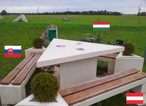
History (and sometimes, unfortunately, current events) shows us just how easily national borders can change, but we still like to think that they are permanent fixtures. These photos of different national borders around the world show you how both friendly and hostile nations like to fence off their turf.
Canada is a massive country, yet it has one of the lowest population densities in the world. Despite this, Canadians have made a wide impact on their land, much of it visible from aerial and satellite photography. Hydroelectric facilities, roads, mines, farms, ports, resource exploration, logging, canals, cities, and towns have altered much of the landscape over the years.
|


#GEO130