Human Interest
199.1K views | +8 today
Follow
Human Interest
Your new post is loading...
Scooped by Skuuppilehdet
Scoop.it!

Why Mercator for the Web? Isn’t the Mercator bad?

Why Mercator for the Web? Isn’t the Mercator bad? | Human Interest | Scoop.it

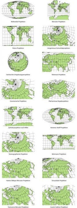
"As you may know, Google Maps uses the Mercator projection. So do other Web mapping services, such as Bing Maps and MapQuest. Over the years I’ve encountered antipathy toward the use of the Web Mercator from map projection people. I know of two distinct schools of opposition. One school, consisting of cartographic folks and map aficionados, thinks the Mercator projection is 'bad': The projection misrepresents relative sizes across the globe and cannot even show the poles, they are so inflated. The other school, consisting of geodesy folks, thinks mapping services have corrupted the Mercator projection, whether by using the wrong formulæ for it or by using the wrong coordinate system for it."
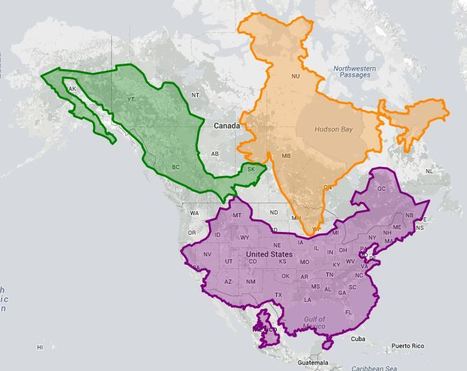
Rescooped by Skuuppilehdet from AP Human Geography
Scoop.it!

The true size of ...

The true size of ... | Human Interest | Scoop.it
This site is used to highlight the distortion issues caused by the Mercator map projection. It can be used to show the true size of countries

How it Works

1. Enter a country or state name

2. Hover over selection for size information

3. Click on selection to drag

4. Right-click on selection to delete


Tags: mapping, visualization, map projections, cartography, perspective.


Via Courtney Barrowman
Scooped by Skuuppilehdet
Scoop.it!

Map Projections

Map Projections | Human Interest | Scoop.it

A map projection is used to portray all or part of the round Earth on a flat surface. This cannot be done without some distortion.  Every projection has its own set of advantages and disadvantages. There is no "best" projection.  The mapmaker must select the one best suited to the needs, reducing distortion of the most important features.  Mapmakers and mathematicians have devised almost limitless ways to project the image of the globe onto paper. Scientists at the U. S. Geological Survey have designed projections for their specific needs—such as the Space Oblique Mercator, which allows mapping from satellites with little or no distortion.  This document gives the key properties, characteristics, and preferred uses of many historically important projections and of those frequently used by mapmakers today.

Carlee Allen's curator insight, March 26, 2015 6:58 PM

This article explains and talks about 18 specific map projections. It gives a lot of detail about all of them, and describes the disadvantages and uses for all of them.


I thought that this was interesting because I learned more about map projections, and actually how people use them.

Leah Hood's curator insight, August 22, 2017 5:02 PM

This article chronicles 18 map projections, how they are mathematically rendered with their own unique set of advantages and disadvantages. 


Questions to Ponder:  Why do map projections matter?  Is one global map projection inherently better than the rest?  What is your favorite?  


Tags: Mapping, visualization, map projections, cartography, perspective.

Scooped by Skuuppilehdet
Scoop.it!

Earth From the ISS

"Watch along with Expedition 38 crew members Mike Hopkins and Rick Mastracchio as they look at various cities across the globe from the vantage point of the cupola on board the International Space Station."  


Tags: mapping, perspective, images, remote sensing, geospatial, unit 1 Geoprinciples.

No comment yet.
Scooped by Skuuppilehdet
Scoop.it!

What Does Earth Look Like?

Courtney Barrowman's curator insight, August 27, 2014 12:37 PM

Unit 1

MsPerry's curator insight, September 1, 2014 9:51 AM

APHG-Unit 1

Alex Smiga's curator insight, September 7, 2015 4:29 PM
Seth Dixon's insight:

This video covers various topics important to mapping and satellite imagery (and alesson from an APHG teacher on how to use this video with other resources).  There is so much more to the world and space than what we can see see.  Chromoscope, referenced in the video, simulates other forms of energy on the electromagnetic spectrum besides just visible light.  This type of information is at the core of the science behind all of our satellite imagery.  This video also covers many map projection issues and highlights online resources to understand map distortion including:

Google’s Mercator Map PuzzleJason Davies’ interactive map projection websiteInteractive Gnomonic Projectionand the military's live rendering of what the Earth looks like right now.  
Rescooped by Skuuppilehdet from Mr Tony's Geography Stuff
Scoop.it!

Map Projection Transitions

Map Projection Transitions | Human Interest | Scoop.it

"In some ways, all 2D maps of Earth are interrupted at some point, even if it’s just along the antimeridian at 180°. Interruptions are often in areas of less interest e.g. oceans for a land-focused map."


Via Tony Hall
Luis Cesar Nunes's curator insight, September 3, 2015 10:33 AM

map projections

Alex Smiga's curator insight, September 7, 2015 4:23 PM
Seth Dixon's insight:

No screenshot could do justice to this animation.  It transforms a map of the world from one map projection to another, and in the 5 second interval it 'spins the globe' to give you a sense of the the spatial distortions inherent in all projections.  This is but one of the many visualizations fromJason Davies mapping project.   

Vincent Lahondère's curator insight, January 4, 2018 5:42 PM

Un site qui permet de visualiser les principales projections cartographiques

Rescooped by Skuuppilehdet from Geography
Scoop.it!

Bad Maps Are Everywhere These Days. Here's How to Avoid Being Fooled

Bad Maps Are Everywhere These Days. Here's How to Avoid Being Fooled | Human Interest | Scoop.it
Tips from a geographer who's seen it all.


Tags:  mapping, cartography, 201, perspective, map.


Via CT Blake
Angus Henderson's curator insight, July 2, 2015 2:04 AM

A mapping 'take-down' of great detail, with lots of of interesting linked examples

Scooped by Skuuppilehdet
Scoop.it!

Why Map Projections Matter

Rich Schultz's curator insight, February 11, 2015 11:27 AM

Would an inverted Peters projection "freak you out"?

Tiani Page's curator insight, April 27, 2015 11:51 PM

As part of geography education we are required to teach students about different map projections and the rationale for these. This little video puts it quite well. 

Adelaide Parkin's comment, September 7, 2016 8:52 PM
This is an engaging and funny clip! It is a great resource that could be used in a lessons introduction! for myself i love finding funny little clips that relate to a topic to play at the start of a lesson and then explain to the students what the topic is! Great resource i will be saving for later
Rescooped by Skuuppilehdet from AP HUMAN GEOGRAPHY DIGITAL STUDY: MIKE BUSARELLO
Scoop.it!

Map Fight

Map Fight | Human Interest | Scoop.it

Via Mike Busarello's Digital Storybooks
Scooped by Skuuppilehdet
Scoop.it!

Cartographic Anomalies: How Map Projections Have Shaped Our Perceptions of the World

Cartographic Anomalies: How Map Projections Have Shaped Our Perceptions of the World | Human Interest | Scoop.it

Elizabeth Borneman explores how cartography and cartographic projections help and hinder our perception of the world.

"How do you think the world (starting with our perceptions) could change if the map looked differently? What if Australia was on top and the hemispheres switched? By changing how we look at a map we truly can begin to explore and change our assumptions about the world we live in."


Geography doesn’t just teach us about the Earth; it provides ways for thinking about the Earth that shapes how we see the world.  Maps do the same; they represent a version of reality and that influences how we think about places. 


Tags: mapping, perspective.

samantha benitez's curator insight, November 22, 2014 2:53 PM

helps show the different perspectives of our world and how it has changed. also shows many different forms of mapping our world throughout time.

Emily Coats's curator insight, May 27, 2015 10:34 AM

UNIT 1 

This article discusses map projections and how they shape our perception of the world. Maps influence how we see the world, and could change the way we see it as well. These projections show us many different views of the Earth, which is very influential to our perspectives. This applies to unit 1 and its major concepts and underlying geographical perspective such as analyzing maps. 

Vicki S Albritton's curator insight, August 26, 2016 8:35 PM
What we see isn't always what is.