


If you could go back in time to the 1980s, you would find a city that is drastically different than today’s Shanghai.
Via Mike Busarello's Digital Storybooks
Get Started for FREE
Sign up with Facebook Sign up with X
I don't have a Facebook or a X account


 Your new post is loading...
 Your new post is loading...
Your new post is loading...
If you could go back in time to the 1980s, you would find a city that is drastically different than today’s Shanghai. Via Mike Busarello's Digital Storybooks 

Mr Mac's curator insight,
June 13, 2017 10:17 AM
Unit 7 - Urban Sprawl

Kelsey McIntosh's curator insight,
May 3, 2018 10:12 PM
Shanghai os growing at an incredibly rapid rate. As more and more people begin to inhabit the city, the neighboring towns have morphed into one large city. However, the city's amazing population increase has taken a toll on its ecosystem. With the rapid growth, Shanghai's temperature has increased dramatically. Similarly, the wild and plant life has declined in the region as well.
Sign up to comment

Rapid growth in several cities along the Pearl River Delta has made a Chinese megacity larger and more populous than any other urban area in the world.

Tanya Townsend's curator insight,
November 16, 2015 8:50 PM
Already this image is showing a clear impact that the massive increase in population is having on the landscape. The delata has narrowed and so has the major rivers. As population grows in mega cities like this so doesnt the increase for resources such as water, also when it increases this quickly sanitation practices decrease. One can only imagine the inpact on water quality this is also having. 
Benjamin Jackson's curator insight,
December 13, 2015 7:46 AM
It is amazing how fast a modern city can come about when there is no historical city to base the subsequent growth on. 
Nicholas A. Whitmore's curator insight,
December 16, 2015 3:39 PM
It is astounding the amount of growth this one city has had in one decade and reminds me of some of the rapid development within the Middle East since the 70s which transformed cities like Dubai. Ecologically like most of what China does it is a disaster but fascinating from a development one. Unfortunately the article doesn't offer a population so that it could be compared to Tokyo's since a size comparison was done in terms of land use. Hopefully China will find a sustainable method of growth because if city continue to grow like this it will be surprising if they could maintain stability. I personally thing this rapid growth is dangerous and like India they likely won't be able to keep up. Additionally since China's economy is very reliant on this type of growth it is concerning to think of what may happen to many of these cities when the growth they rely on stops.

Stunning images taken from space put the world's crises into context. U.N. satellite imagery has tracked the evolution of the camp since its creation. The exponential growth is remarkable. The refugee camp is rapidly taking the shape of a real city — structured, planned and even separated into neighborhoods and subject to gentrification. Tags: refugees, migration, conflict, political, war, squatter, urban, unit 7 cities, remote sensing, geospatial.

Norka McAlister's curator insight,
March 15, 2015 8:00 PM
I definitely think that it would. It is impressive to see how a urban planning affected the land designed by the refuges. Within a few years through satellite imaging, we can witness and appreciate how the Zaatarie refugee campus went from a few refugees to a total urbanized area receiving and distributed more than 85,000 refuges in the area. Urban planning plays a big role in regards to how display all populations. However, we have to take in consideration that when a massive population in one area is displayed, urban area is also relevant in terms of disciplines, public healthy, collaboration to live under a community rules. On other hand, natural disasters and destruction by war can wipe out entire cities within seconds. The satellite images were able to show the destruction that took place in the Syrian city of Hamas after natural diasters devastated the region and the wartorn afternmath of Gaza city. Natural disasters and war trigger a massive migration of refugees in search for better a life and opportunity. 
Max Minard's curator insight,
March 21, 2015 9:26 PM
This report refers to the Zaatari refugee camp in Jordan which is experiencing rapid growth in population with 85,000 citizens and is even starting to look as a "city built form scratch". The reason geographers think that satellite imagery can save refugee lives is because it allows them to view areas of the camp in which they are unable to reach on ground. This information will help health workers pinpoint these certain hidden areas and tend to the people who are there. This use of satellite imagery centers around the camps rapid growth in population, making it quite a challenge to scale on ground.
Over the years, ISS astronauts have had a rare opportunity to witness climate change on Earth from space. Via Sally Egan

Sally Egan's curator insight,
March 30, 2014 7:29 PM
A great illustation of the changes to the environment as a result of increasing technology and population. Plays for 1minute 30.
Sally Egan's curator insight,
March 30, 2014 7:34 PM
A short but fascinating illustration of the rapid changes to areas of teh Earth, observed by astronauts since 2000. Plays for 1 minute 30. |
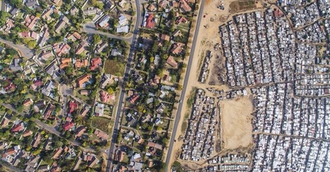
An American used drones to capture the color lines still stark in South African cities. Via Mike Busarello's Digital Storybooks

Richard Aitchison's curator insight,
March 9, 2018 10:13 AM
"I agree with you, I think that the images are chilling. And they communicate so well what is otherwise a very complicated and nuanced issue to discuss—separation, segregation, history, disenfranchisement. But the images cut right to the heart of the matter, which is that these separations are not right" This is a quote in the article from the man that took the pictures (Johnny Miller). These photos show us the lines of segregation that continues even in a post Apartheid South Africa. These are amazing images and really quite unbelievable. We think of different segregation here in America, but what these photos show are unlike anything that I have personally seen. As stated in the article the author hopes to create conversations about these separations. We see planned spatial separations that we created by city planners and we must used these as lessons going forward and as jumping off points to discuss. These shocking images can help inform us as a society that we must improve our social issues and if we don't we will continue to see issues like this grow both here in South Africa and around the world. One can see while tensions would be so high as a clear divide in living standards can rightfully cause anger. Eventually this anger leads to hate and this hate leads to an up rise in the people.

Katie Kershaw's curator insight,
March 31, 2018 4:23 PM
South Africa is one of the few countries that has a similar history in regards to racial segregation as America. What makes their case unique is that the African population was there first and the English came in and created a system in which they were superior. Although they have been officially desegregated for almost 20 years, these photos show that there are still underlying issues that exist. These photos reveal that on one side of a particular area, the homes look like a typical suburban area where right across from that there are areas that resemble slums. The areas that are more developed and wealthy have a majority white population and the poorer, less developed areas have large black populations. The affects of segregation are long lasting and not solved overnight. Just because government policies say that discrimination on a racial basis is illegal, doesn’t mean that society will neatly reorganize itself. I think that the craziest part of this for me was that even the landscaping is vastly different despite the closeness of the two areas. The wealthier part has lush green and the poorer parts have dirt and sand. This an example of physical geography providing evidence for a societal separation.

David Stiger's curator insight,
November 10, 2018 6:22 PM
Just because a formal social construct - an idea in the human mind - changes, does not mean that change, or desire to alter course, is reflected in the real world. While the idea of apartheid in South Africa came to an end, the real world in the form of urban geography has yet to catch up. The urban planning under apartheid still carries the legacy of color codes and demarcated boundaries between "races" in order to cement socioeconomic inequity. This situation in South Africa is similar to the United States after the Civil Rights movement ended the era of Jim Crow. Even though laws were passed, the geography remained largely untouched. Black neighborhoods remained socially and economically segregated - the only difference being that the law did not mandate this. The law never stipulated geographic changes or economic prescriptions like wealth redistribution. It turns out that human geography and philosophical principles can be at odds with each other, as demonstrated by the aerial photographs of South African cities.

Ambre Cooper's curator insight,
June 25, 2015 4:04 PM
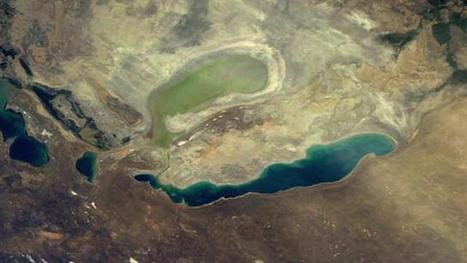
This is a cool little video. It even shows the level of Aral Sea we read about. 
Hamdou Wane's curator insight,
June 29, 2015 7:55 AM
Satellites have been watching us for 40 years. Here's what their images reveal 
Alex Smiga's curator insight,
August 6, 2017 8:45 AM
Seth Dixon's insight:
This video is simple entry point into the various applications of remote sensing as well as various human and environmental interactions. This video highlights 5 examples: 1. Deforestation (Brazil) 2. Water Use (Aral Sea) 3. Urban Sprawl (Las Vegas) 4. Energy (Coal in Wyoming) 5. Climate Change (Ice Shelf in Antarctica)

"60 years has made a big difference in the urban form of American cities. The most rapid change occurred during the mid-century urban renewal period that cleared large tracts of urban land for new highways, parking, and public facilities or housing projects. Fine-grained networks of streets and buildings on small lots were replaced with superblocks and megastructures. While the period did make way for impressive new projects in many cities, many of the scars are still unhealed. We put together these sliders to show how cities have changed over half a century. In this post, we look at Midwestern cities such as [pictured above] Cincinnati, Ohio."

Sierra_Mcswagger's curator insight,
March 10, 2015 10:22 AM
In the above picture of Cincinnati, Ohio it is clear how much change American cities have undergone in 60 years. In the process of urban renewal these cities have been affected tremendously with the addition of new roads, businesses, and most likely the turning of land over to private developers. All previous land has been renovated and changed into the typical urbanized American city. S.S. |


