

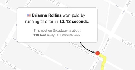
"What would Olympic races look like if they took place near you? Enter your address below to find out, or keep clicking the green button to explore races that begin in where you live."
Get Started for FREE
Sign up with Facebook Sign up with X
I don't have a Facebook or a X account


 Your new post is loading...
 Your new post is loading...
Your new post is loading...
"What would Olympic races look like if they took place near you? Enter your address below to find out, or keep clicking the green button to explore races that begin in where you live." 
No comment yet.
Sign up to comment

From
www

"Two archaeologists, who recently published their findings in the American Schools of Oriental Research, used Google Earth satellite images and drone photography to identify the outline of an enormous monument buried beneath sand and time at the UNESCO World Heritage site in Jordan." --Motherboard

Zavier Lineberger's curator insight,
March 29, 2018 3:38 PM
(Middle East) Using modern technology, archaeologists have discovered a new monument hidden underground in Petra. The find, dated around 150 B.C., is thought to be a ceremonial site with two platforms, pottery. columns, and a staircase carved out of stone. It is amazing that there are still new finds like this in the 21st century, but the history of the Middle East is so incredibly old, with so many extinct civilizations, that archaeologists will probably keep making new breakthroughs.

brielle blais's curator insight,
April 1, 2018 4:40 PM
Physical geography can be really cool as understanding the current land helps to also understand the past. Researchers finding new monuments like this in Petra shows the importance of knowing the land around you, or someplace important like where the UNESCO World Heritage Site.

Flo Cuadra Scrofft's curator insight,
March 21, 2015 9:38 PM
This presentation talks about the misconceptions of geography and about what it really involves. Geographers describe and try to explain how locations interact and relate to one another; are arranged the way they are; and have become what they are now. They also use critical thinking to project what the world might look like in the future. As there's usually so many questions that have to be answered, geography is an interdisciplinary work, meaning that it is a blend of natural sciences, social sciences, and humanities. Geographers also develop other skills, such as mapping and graphing (spatial representation skills) and development of verbal concepts, frameworks and mathematical models (spatial theorizing skills). Geography, therefore, can be used to study many issues, such as climate change, sustainability, human rights, among others. Reflection- as the presentation accurately shows, many people believe that geography is just about memorizing countries and our world's natural resources locations, but in reality, geography goes much deeper than that. Geography is about asking questions and trying to come out with the best answers in order to solve issues that can range from local usage of land to international security. 
Gregory Stewart's curator insight,
August 29, 2015 9:37 AM
Prezi created by students interested in the field of geography. 
Alex Smiga's curator insight,
September 7, 2015 4:26 PM
Seth Dixon's insight:
This Prezi was created by students from theSyracuse Geography Department as part of a Senior Seminar to explain the disciple, the major and its utility. This is a great recap of the discipline, the major and it's utility.
Alex Smiga's curator insight,
September 7, 2015 4:29 PM
Seth Dixon's insight:
This video covers various topics important to mapping and satellite imagery (and alesson from an APHG teacher on how to use this video with other resources). There is so much more to the world and space than what we can see see. Chromoscope, referenced in the video, simulates other forms of energy on the electromagnetic spectrum besides just visible light. This type of information is at the core of the science behind all of our satellite imagery. This video also covers many map projection issues and highlights online resources to understand map distortion including: Google’s Mercator Map PuzzleJason Davies’ interactive map projection websiteInteractive Gnomonic Projectionand the military's live rendering of what the Earth looks like right now. |

How to tell two radically different stories with the same dataset.

Jose Sepulveda's curator insight,
July 29, 2016 1:19 PM
thee precaution should be taken with environmental data published as integrated variable maps

Colleen Blankenship's curator insight,
August 4, 2016 9:12 AM
Maps, like statistics, can tell very different stories using the same information! Read this for some examples!
From
www
"Pisa tests, an international standard for comparing education systems around the world, could include a new measurement of global skills in the next round of tests in 2018. The OECD, which runs the tests in maths, reading and science, is considering adding another test which would look at how well pupils can navigate an increasingly diverse world, with an awareness of different cultures and beliefs. The OECD's education director Andreas Schleicher explains why there is such a need for new rankings to show young people's competence in a world where globalisation is a powerful economic, political and cultural force. Education leaders around the world are increasingly talking about the need to teach 'global competences' as a way of addressing the challenges of globalisation."

Euneos's curator insight,
June 2, 2016 1:23 AM
Kansainvälistyminen nousee uudeksi mitattavaksi asiaksi PISA-tutkimuksissa 2018. Miten mahtaa suomalaisten peruskoulujen käydä? Pystyvätkö ne globaalitaidoissa ja kulttuurienvälisessa osaamisessa yltämään samalle tasolle kuin kansainvälistymisessä pitkälle edistyneet Britannia, Hollanti, Belgia tai Tanska. Oma kokemukseni jo 10 vuotta jatkuneesta Intia-yhteistyöstä (http://www.eumind.net) ei ennakoi Suomen kouluille huipputuloksia. Mutta toivotaan parasta.

"As you may know, Google Maps uses the Mercator projection. So do other Web mapping services, such as Bing Maps and MapQuest. Over the years I’ve encountered antipathy toward the use of the Web Mercator from map projection people. I know of two distinct schools of opposition. One school, consisting of cartographic folks and map aficionados, thinks the Mercator projection is 'bad': The projection misrepresents relative sizes across the globe and cannot even show the poles, they are so inflated. The other school, consisting of geodesy folks, thinks mapping services have corrupted the Mercator projection, whether by using the wrong formulæ for it or by using the wrong coordinate system for it."
"Watch along with Expedition 38 crew members Mike Hopkins and Rick Mastracchio as they look at various cities across the globe from the vantage point of the cupola on board the International Space Station." Tags: mapping, perspective, images, remote sensing, geospatial, unit 1 Geoprinciples.
|


