


A groundbreaking Mapbox project ushers in a new era for online cartography.
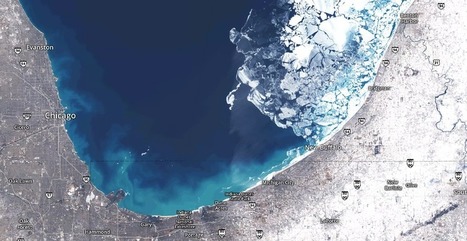
On Google Earth, the seasons rarely change. Most anywhere a digital traveler goes, the sky is cloudless and the grass is green. No snow on the ground in Iowa. No fire in Valparaiso. It's a big gap between the world as it is and as it's mapped.
Launched Thursday,a landmark project from Mapbox has changed the summertime paradigm for online cartography. Landsat-live reveals the planet's surface in real time and in stunning resolution, fed by a constant stream of public-domain imagery from NASA’s Landsat 8 satellite.
Via Mike Busarello's Digital Storybooks


 Your new post is loading...


In this article we are shown the development and evolution of cartography. We can observe the changing geography on the planet and the real time gives us an accurate reading. I feel like this innovation could greatly help us.
Summary: This interesting article talks a lot about modern technologies effect on the popularity of geography. This article talks about how programs like Google Earth have caused a general interest to arise about physical geography.
Insight: This article is significant to unit 1 because it shows how GIS can be so influential to not only geographers but to the rest of society.
unit 1