Notes on an Imagined Plaque to be Added to the Statue of General Nathan Bedford Forrest, Upon Hearing that the Memphis City Counci has Voted to Move it and the Exhumed Remains of General Forrest and his Wife, Mary Ann Montgomery Forrest, from their Current Location in a Park Downtown, to the Nearby Elmwood Cemetery
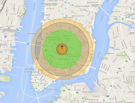
"Maps bring the horror of Hiroshima home -- literally.
Alex Wellerstein, a nuclear historian at the Stevens Institute of Technology, created a NukeMap that allows you to visualize what the Hiroshima and Nagasaki explosions would look like in your hometown. Kuang Keng Kuek Ser at Public Radio International has also developed a version, using slightly different estimates.
Here is what Little Boy, the Hiroshima bomb, would look like on Wellerstein's map if detonated in New York City."
I highly suggest tinkering around with "NukeMap," as I have spent the last 30 minutes seeing how different bombs would destroy my neighborhood and the surrounding areas- it will even adjust for varying casualty rates in areas with higher or lower populations, even just by moving the detonation site a couple of streets away. It's pretty cool at the surface, but to examine the destructive capabilities of some of these weapons is downright terrifying. You view the blast radius encompassing your home, your entire existence, on a computer screen, and its easy to forget the devastation of it all disappearing. For those who survived the atomic bombs dropped at Hiroshima and Nagasaki, there was no simulation to tinker with, but instead a reality more terrible than anything I've ever had to endure in my own personal life. Thousands of lives lost, thousands more left irreversibly shattered, never to be the same again. All because men in government buildings on opposite sides of the ocean couldn't get along. No one wins in war.
People have been farming — and eating — a GMO for thousands of years without knowing it. Scientists have found genes from bacteria in sweet potatoes around the world. So who made the GMO?
Once again, the term GMO has been used without regard for process. We need to make sure our students have a clear understanding of what it means for a crop to be "genetically modified" now. Although I get some eyerolls, this is why I continue to include an origin of agriculture segment in every introductory class I teach..
Yes, the title is somewhat misleading (isn't that almost expected these days?), since humanity has been selectively breeding crops since the first agricultural revolution and genetic alteration can occur independent of human intervention. Humanity has always been using the best technologies available to improve agricultural practices. The term GMO though, is usually reserved for scientific, technological modifications that were unimaginable 100 years ago.
"When tourists visit sub-Saharan Africa, they often wonder 'Why there are no historical buildings or monuments?' The reason is simple. Europeans destroyed most of them. We only have a few drawings and descriptions by travelers who visited the places before their destruction. In some places, ruins are still visible. Many cities were abandoned when Europeans brought exotic diseases (smallpox and influenza) which started spreading and killing people. Most of those cities lie hidden. In fact the biggest part of Africa history is still under the ground."
The issues with poverty and hunger that grip certain parts of Africa- particularly the sub-Sahara- find their roots in the utter subversion and destruction of African societies and states during the Trans-Atlantic Slave Trade and the subsequent colonization of Africa. European traders placed significant strain of existing African states during the 14th and 15th centuries, as the emergence of "slave states" and the extent of the trade completely changed the demographics of much of Africa. Labor shortages lead to technological shortfalls as well as the dissolution of many African states, as predatory states continued to destroy many civilizations and cultures. By the time that the majority of the West had banned the trade in the 19th century, the damage had already been done; many of the great civilizations of Africa had regressed or been entirely wiped out under the pressure of Europe's demand for slaves. The subsequent colonization of the continent only worsened matters for the Africans, as major hubs of civilization were captured, raided, and destroyed. Traditional societies were subjected to European influences and religion and eventually lost, and yet Europeans looked at the destruction and the lack of economic and political progress their actions had caused and blamed it on the inferiority of the Africans themselves. History has not been kind to Africa, and it is important to remember that that is not her fault. Many civilizations, cities, and states were lost as a direct result of contact with Europeans during the slave trade and the subsequent colonization of the continent.
Before European contact, Africa had a number of great urban cities. European arrival foresaw the destruction of those once grand cities. The Europeans brought diseases such as smallpox and influenza to the African continent. Those diseases would hamper the previously unexposed African population. Slavery also drained Africa of millions of people as well. Great African civilizations were brought down by these various calamities. European arrival was the death knell of the great African civilizations. Africa is still living with this legacy of destruction. Africa is the most rural region in the world, because of this legacy.
TELEVISION DOCUMENTARY: Examines the slum areas of Cincinnati, Ohio, and provides extensive views of substandard housing in various parts of the city. Describes the problems of the uneducated and unemployed who cannot escape from poverty, but finds a "ray of hope" in a young school child. Offers no solution for eliminating urban poverty, but states that everyone "must try."
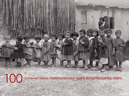
“For most of the world, the Armenian Genocide is the slaughter you know next to nothing about. But every year on April 24, Genocide Remembrance Day, we Armenians remember the injustice of a crime that is rarely acknowledged and often flatly denied. It was April 24, 1915, when the Armenian intellectuals, professionals, editors and religious leaders in Constantinople were rounded up by the Ottoman authorities — and almost all of them executed. During World War I, the Ottoman Empire killed three of every four of its Armenian citizens. The majority of Armenians alive today are descendants of the few survivors.”
Cada año el 24 de abril, día de la conmemoración del Genocidio, nosotros los armenios recordamos la injusticia de un crimen que rara vez se reconoció y a menudo negó rotundamente.
Era el 24 de abril de 1915, cuando los intelectuales armenios, profesionales, editores y líderes religiosos de Constantinopla fueron detenidos por las autoridades otomanas - y casi todos ellos ejecutados. Durante la Primera Guerra Mundial, el Imperio Otomano mató a tres de cada cuatro de sus ciudadanos armenios. La mayoría de los armenios vivos hoy son descendientes de los pocos sobrevivientes ".
I have to be honest, I never knew we had a Genocide Remembrance Day. As I get older, there seems to be a day for everything. This is a horrific act. Unfortunately, as we've seen historically many countries have tried this. There is never a good outcome. It's atrocious that we could ever standby and not do something.
For most of the world, the Armenian Genocide is the slaughter we know almost nothing about. But every year on April 24,Genocide Remembrance Day, Armenians all over the world remember the injustice of a crime that is rarely acknowledged and often flatly denied. It was April 24, 1915, when the Armenian intellectuals, professionals, editors and religious leaders in Constantinople were rounded up by the Ottoman authorities — and almost all of them executed. During World War I, the Ottoman Empire killed three of every four of its Armenian citizens. The majority of Armenians alive today are descendants of the few survivors
Wow. As a history major, I found this map timeline really interesting and really cool. It's a great example of how even though the physical geography of a place can remain the same, its political and economic geography can change so rapidly (or not so rapidly). It was especially interesting to see the brief stints that entities such as the Republic of the Rio Grande or the Confederate States of America did in the dividing up of North America over the last two and a half centuries. For someone who knows nothing about U.S. history, those blips on the radar beg the question, "what happened there?" How can a political entity encompass a geographic region and then disappear just as quickly?
And that ties into what I think this map is really about: colonialism. This map says a great deal about how European (or Western) empires carved up the New World and what some of their political or economic goals were in the times that the map shows. It's also important to note the title of the map: "Non-Native American Nations Control over North America". So as we see the map changing to show European or United States expansion, what we DON'T see is the gradual loss of land experienced by the various Native American tribes that inhabited the continent long before Europeans ever laid eyes on it. This map, therefore, highlights how political and economic geography can change so drastically when groups with a lot of economic, political, and military power are at odds with groups who are severely disadvantaged in these areas.
This map is an excellent resource in show the evolution of colonial claims to North America.. It is fascinating to watch all the political changes that have occurred on the continent in over the past 500 years. The biggest change is the evolutions of the United Sates from a small city state like nation to an empire on both the Atlantic and Pacific oceans. This is also an extremely sad story to be told from this map. The loss and destruction of Native Americans is next to slavery is the greatest sin of America. This map tells the complex story of our Continent.
Most of the world's major religions are made up of multiple sects or denominations, and Islam is no different. Islam's two major sects are the Sunnis and the Shiites, and the division and interplay between the two is a major factor in the geopolitics of the Middle East. How well do you understand Sunni and Shiite Islam? Take our quiz and find out!
After taking this class about Political Islam I thought I knew about Sunni and Shiite Islam. Taking this quiz I definitely mixed up a lot of the information. It seems like it would be simple to understand the differences and the similarities, but they are so parallel its easy to get the information mixed up.
"Muslim Extremists!" "Death to militant Islam!" "Muslims are terrorists!" These cries are often heard from conservative factions of the United States, who are a lot more eager to blindly hate than they are to learn about the lives of the same people they want dead. Islam encompasses some 1.3 billion believers, and there are significant deviations in both the faith and its application among such a wide population of believers. Before this exam, I knew about the Sunni majority and the Shia minority currently in conflict in the Middle East, but my understanding of the distinction between the two faiths was vague at best. I also did not recognize that each of the two main branches are then further split into different denominations, much in the same way that Christianity is today within our own country. As different and "other" we try and make the Middle East out to be, they are not that different in their religious practices (and their fanatics ruining the name of the religion for everyone else) than many conservatives would like them to be. I definitely enjoyed taking this exam, particularly within the context of everything I have been learning about with what is happening in Syria. I had no idea Assad was not just a regular Shia, but instead a member of a much smaller, stricter denomination. Learning about this region has definitely been an eye-opening experience for me, in the sense that I know a lot less about the world than I thought I knew.
I am not very educated on the religion but I do know from my notes in class that religion is what stops Iraq from unifying. That country is made up of three religions Muslims , Sunnis and Shiites.
Mark Twain declared that the Indian city of Varanasi was older than history, tradition and legend. He was, of course, wrong. So which exactly is the world’s most ancient continuously inhabited city?
Since the beginning of civilization, rivers have been communities' main job source. Even before B.C., the only one way to survive was to construct houses close to the nearest body of water. In the case of Crocodile City near the Nile river in Africa,the city was built close to the river due to the fertile soil and water supplied by the Nile. This enabled ancient civilizations to survive. Unfortunately, due to religious conflict between communities, some of these original civilizations were forced to relocate. Another reason for relocation is due to the movement of the bodies of water. As the paths of the rivers change, communities are forced to abandon their homes and start new civilizations so to remain close to the waters. All these communities around the river Nile relied on agriculture for its wealth and power. All these cities are examples of civilizations that have inhabited areas near rivers for centuries, even before B.C. Given their habitat, rivers will provide the necessar resources and tools for current and future generations to be able to survive.
Although the question is misleading, it should say what is the oldest continuously inhabited city in the world, I enjoyed the article as once again I learned quite a bit about ancient history. Seems Aleppo, Syria is the apparent winner. They have dated the city to 6000 BC and nomads were there 5000 years before that. Shows the importance of trade as most of the contenders were on a trade route near a body of water. In fact, the article says that Aleppo was very much involved in trade until the opening of the Suez canal. Let's hope that with all the turmoil in Syria that Aleppo continues to thrive for centuries to come. Constantinople and Damascus were serious contenders but could not show continuous habitation. Aleppo according to the article, was a strong contender for commerce alongside Cairo, Egypt. Another contender, Jericho, dates back to 9000 BC but again was not continually inhabited and thus cannot lay claim to the world's oldest city.
"Nothing unites different nations quite like mutual enemies. But the 'Auld Alliance' between Scotland and France - both historic rivals of England - doesn't mean that the French government favours Scottish independence. Far from it."
Even though in past years France and Scotland have been friendly and wanted the best for each other, Scottish independence is not on the list of things to do for France. They have good blood together, sharing foods, music and alcohol at festivals there is no need to worry about any hatred happening even if the French does not back Scotland's independence. While some think that France would think that areas like Brittany and Corsica would want independence from France that is not the reason. To keep checks and balances in place a strong United Kingdom is needed to keep Germany in line. With the independence of Scotland, the UK gets a little bit weaker and France is not okay with that.
Ninety-five years ago today, European diplomats gathered at a porcelain factory in the Paris suburb of Sèvres and signed a treaty to remake the Middle East from the ashes of the Ottoman empire. The plan collapsed so quickly we barely remember it anymore, but the short-lived Treaty of Sèvres, no less than the endlessly discussed Sykes-Picot agreement, had consequences that can still be seen today. We might do well to consider a few of them as the anniversary of this forgotten treaty quietly passes by.
This 11 minute video from the archives is a great profile of a community in flux. Orange County, Florida was transitioning from an agricultural region off the grid to a largest tourist destination in the United States. Obviously, the community's economic geography completely transformed, but the cultural shift to the region was equally drastic. Since Disney today is such a well-known brand and so many students have been to Disney World, they will enjoy seeing what the community was like before it became an entertainment mecca.
Admittedly, I've got a thing for monuments in the cultural landscape. This is a very nice article for a historical geographer on how memory and heritage are enshrined in the landscape; this process politicizes history in ways that shape the national narrative, and that shapes how we think in past. Using historical geography to understand the debates in the news? No way!! Here James Loewen writes in the Washington Post on the topic for a general audience.
This video is about how a world wide pandemic can occur and has occurred in history. I thought this was interesting because it spoke of many specific events like the black death and the 2010 cholera outbreak in haiti, gave detailed information, and was very informal.
This relates to unit 1 because it shows how pandemics and epidemics occur in a detailed way. It also shows how geography has related to epidemic outbreaks by showing disease spread maps and showing how doctors used this to solve the issue of it.
Beginning in the 1950s, cities demolished thousands of homes in walkable neighborhoods to make room for freeways.
At the time, this was seen as a sign of progress. Not only did planners hope to help people get downtown more quickly, they saw many of the neighborhoods being torn down as blighted and in need of urban renewal. But tearing down a struggling neighborhood rarely made problems like crime and overcrowding go away. To the contrary, displaced people would move to other neighborhoods, often exacerbating overcrowding problems. Crime rates rose, not fell, in the years after these projects. By cutting urban neighborhoods in half, planners undermined the blocks on either side of the freeway. The freeways made nearby neighborhoods less walkable. Reduced foot traffic made them less attractive places for stores and restaurants. And that, in turn, made them even less walkable. Those with the means to do so moved to the suburbs, accelerating the neighborhoods' decline.
It is really interesting to see how urbanization has affected not just us today but our parents and grandparents. Of course with innovation includes consequence whether good or bad it happens. Go America!
Industrialization changed not only the physical face of cities, but also the social. Innovations such as highways have caused transportation to become widely easier, allowing people from all different regions of the city to travel easily back and forth from place to place.
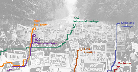
Eleven years after Massachusetts became the first state to allow same-sex couples to marry, the Supreme Court on April 28 will hear arguments about whether to extend that right nationwide. The case comes amid a wave of gay marriage legalization: 28 states since 2013, and 36 overall. Such widespread acceptance in a short amount of time isn't a phenomenon unique to gay marriage. Social change in the U.S. appears to follow a pattern: A few pioneer states get out front before the others, and then a key event—often a court decision or a grassroots campaign reaching maturity—triggers a rush of state activity that ultimately leads to a change in federal law.
We looked at six big issues—interracial marriage, prohibition, women’s suffrage, abortion, same-sex marriage, and recreational marijuana — to show how this has happened in the past, and may again in the very near future.
"Ever since I researched the meanings of monuments in the cultural landscape in Mexico City, I’ve been fascinated by the cultural politics of memory and heritage. The removal of a statue is a cultural 180, acknowledging what was once honored and revered is now something that is not worthy of that distinction. This sort of change is not without protests on both sides and a cultural rearticulation of who 'we' are when 'we' make a public memorial."
The removal of an historical statue, is a broader reflection of what the population of a particular place is thinking. Who a people choose to honor, is a statement of the ideals they hope to espier to. For many people in South Africa, Cecil Rhodes is a symbol of racist colonial tendencies. You can not separate Rhodes from the age of western imperialism. He was one of the leading figures in the scramble for Africa in the late 19th century. In the United States we have seen a similar push to remove statues of historical figures with connections to slavery and racism. Many have called for the removal of statues honoring confederate leaders such as Jefferson Davis or Robert E Lee. The push has even spread to figures beyond those directly connected to the confederacy. The democratic party has removed the names of Thomas Jefferson and Andrew Jackson from there annual party dinners. There connections with slavery and Native American treatment are just too much for some outraged democrats to handle. I am uneasy about the removals of these statues. History can never be erased. It is futile, to even attempt to do such a thing. Historical figures should be judged by the context of the times in which they lived. It is unfair to judge Thomas Jefferson by the standards of our modern age society. The overt political correctness is troubling to say the least. It is a whitewash of history.
The Rise and Fall of the Ottoman Empire can be clearly seen at the beginning and the end. They had a massive territory expansion at 1300 and it bloomed from there. from then to 1900 then only had some minor changes with some changes in territory. At the end, in 1900s was the most significant change with the Empire collapsing with the Republic of Turkey being established in 1923.
A fascinating look into the shifting nature of borders through history. Unfortunately it also reflects many atrocities that also occurred in those years. Geographically the Empire wouldn't last given its difficult to defend borders. Additionally its extremely conservative Political and Cultural nature made it nearly impossible for it to adapt to changing times in technology. Which is ironic in a way because it was their innovation that sparked the Empire and the seizure of Constantinople to begin with. Also it should perhaps be mentioned that the current nation of Turkeys borders are an unnatural creation on the part of the Turks when they were aware their Empire would collapse. This unfortunately also means this map hides events such as the Armenian Genocide to try and purify Anatolia so that the Turks could claim it as its sole homeland while abandoning the rest of the Empire (so in effect they consolidated to try and keep as much land as possible).
This is a very simple GIF map, but one that we can look at using other outside materials and really used to our advantage of seeing the every changing Middle Eastern Area. The Rise and Fall of the Ottoman empire is a key geographical and political fallout from the 1300's until what is now present day Turkey. When you examine the map and see how big the Empire eventually got and what lands it covers we can use this map to interpret some current conflicts like the one in Syria. Also nowadays we do not think of Turkey as a world power or even a regional power. However, it shows there past history as a world power and that can drive a country (see Russia) to wanting to regain that power. Will Turkey look to regain that power as well? What could they possibly to do to regain this power and how would that effect other Middle Eastern countries. We also can look at the map and realize that the region probably contains many people of Turkish acenstory and what effect does that have on political polices in certain countries that had previously been under the power of the Ottoman Empire.
In the 19th century, London was the capital of the largest empire the world had ever known — and it was infamously filthy. It had choking, sooty fogs; the Thames River was thick with human sewage; and the streets were covered with mud. But according to Lee Jackson, author of Dirty Old London: The Victorian Fight Against Filth, mud was actually a euphemism. 'It was essentially composed of horse dung,' he tells Fresh Air's Sam Briger. 'There were tens of thousands of working horses in London [with] inevitable consequences for the streets. And the Victorians never really found an effective way of removing that, unfortunately.'"
London has come a far way from the industrial town it was in the 19th century, and is now cleaner than ever. But pollution led to many issues in London at the time. This is also evident in the developing world today, such as in China, Africa, and South America.
This article is about London, UK during the time of Industrial Revolution. The city of London expanded so rapidly, that there wasn't enough time for urban planning. Factories and houses were going up everywhere, and thousands of people migrated to London for jobs. This led to an influx of filth. The air was polluted and there wasn't adequate irrigation systems or waste systems. Everything dirty could be found on the streets like horse dung, and the water would get polluted and unsanitary.
I liked this article, because it really created an image in my head how terrible and filthy the Industrial Revolution was at the start.
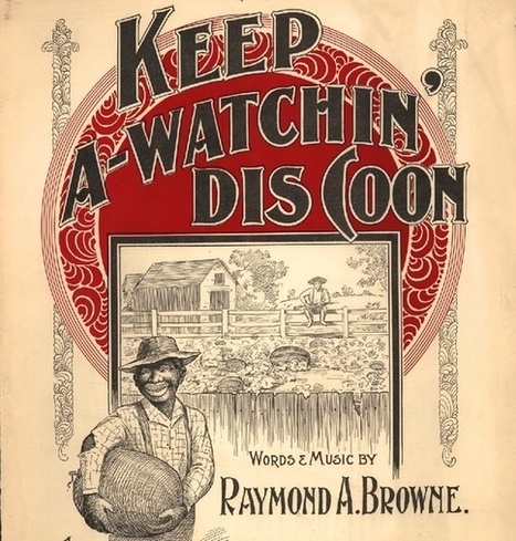
Before its subversion in the Jim Crow era, the fruit symbolized black self-sufficiency.
The stereotype that African Americans are excessively fond of watermelon emerged for a specific historical reason and served a specific political purpose. The trope came into full force when slaves won their emancipation during the Civil War. Free black people grew, ate, and sold watermelons, and in doing so made the fruit a symbol of their freedom. Southern whites, threatened by blacks’ newfound freedom, responded by making the fruit a symbol of black people’s perceived uncleanliness, laziness, childishness, and unwanted public presence. This racist trope then exploded in American popular culture, becoming so pervasive that its historical origin became obscure."
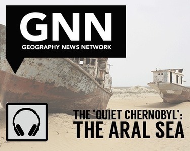
"Prior to the 1960’s, the Aral Sea was the fourth largest lake and approximately the size of Ireland. Fed by both the Amu Darya and Syr Darya rivers carrying snowmelt from the mountains to the southeast, the Aral Sea moderated the climate and provided a robust fishing industry that straddled the present-day border between Kazakhstan and Uzbekistan. For the map savvy, that Aral Sea would be almost unrecognizable—it has long appeared as two basins known as the North and the South Aral Sea since the rivers were diverted for crops, leading to the Aral Sea’s alarming shrinkage. Recent NASA satellite imagery shows the decline that the Aral Sea has undergone since 2000, leaving the South Aral Sea completely dried up in 2014. "
Both this podcast and its title are very interesting. Describing the Aral Sea crisis as a "Quiet Chernobyl" highlights the seriousness of what has happened to the Aral Sea over the previous decades. Though the Aral Sea was not the site of a catastrophic nuclear meltdown, what has happened there is just as harmful to the environment and the population in the surrounding area. The difference between what happened with the Aral Sea and what happened at Chernobyl, however, is that the Aral Sea crisis was avoidable. Chernobyl was an accident, the Aral Sea was not. The warnings of what was to come were clearly present at the Aral Sea, but they were ignored.
This shows how the balance between man and nature is a precarious one that must be monitored closely and heeded constantly. As an oasis in one of the world's driest deserts, the Aral Sea had vast amounts of potential to help facilitate farming and generally help to make life in the area possible. People saw this potential and made use of it. This was not wrong in and of itself. What was wrong was that this potential was overused, with no regards for the long-term effects that it would have on the ecosystem, the climate, and the way of life in the region. The natural geography of a place is very important and can be used by human beings to achieve great things, but as soon as we stop caring about sustainability and future generations, those tools fail and disappear, causing long-term problems that can never be fixed.
The Aral Sea is just one example of an alarming trend happening worldwide, as ill-advised irrigation efforts continue to distort natural geographical formations, climate, and ecosystems. The loss of the Aral is damaging on so many fronts; the loss of an entire ecosystem within its waters, the damages done to the surrounding ecosystems as a result of climate changes and reduction in the food chain directly related to the Sea's disappearance, and the economic repercussions for the people who live in the region. Once a bustling maritime community of trade, the region now lies dormant, the economic realities for the people who once relied on the Sea's waters as dire as the land is dry. Ship hulls line the ground like animal carcasses, the remains of centuries of human life- a stark reminder that man often takes his power too far, too fast. With other large bodies of water facing the same fate in other regions, it is best hoped that the Aral and its ghost crews that now dominate the landscape serve as a reminder to human civilization that, for all our advances, we cannot play "God" and face no consequences.
To get content containing either thought or leadership enter:
To get content containing both thought and leadership enter:
To get content containing the expression thought leadership enter:
You can enter several keywords and you can refine them whenever you want. Our suggestion engine uses more signals but entering a few keywords here will rapidly give you great content to curate.


 Your new post is loading...