


If you could go back in time to the 1980s, you would find a city that is drastically different than today’s Shanghai.
Via Mike Busarello's Digital Storybooks
Get Started for FREE
Sign up with Facebook Sign up with X
I don't have a Facebook or a X account


 Your new post is loading...
 Your new post is loading...
Your new post is loading...
If you could go back in time to the 1980s, you would find a city that is drastically different than today’s Shanghai. Via Mike Busarello's Digital Storybooks 

Mr Mac's curator insight,
June 13, 2017 10:17 AM
Unit 7 - Urban Sprawl

Kelsey McIntosh's curator insight,
May 3, 2018 10:12 PM
Shanghai os growing at an incredibly rapid rate. As more and more people begin to inhabit the city, the neighboring towns have morphed into one large city. However, the city's amazing population increase has taken a toll on its ecosystem. With the rapid growth, Shanghai's temperature has increased dramatically. Similarly, the wild and plant life has declined in the region as well.
Sign up to comment
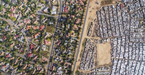
An American used drones to capture the color lines still stark in South African cities. Via Mike Busarello's Digital Storybooks

Richard Aitchison's curator insight,
March 9, 2018 10:13 AM
"I agree with you, I think that the images are chilling. And they communicate so well what is otherwise a very complicated and nuanced issue to discuss—separation, segregation, history, disenfranchisement. But the images cut right to the heart of the matter, which is that these separations are not right" This is a quote in the article from the man that took the pictures (Johnny Miller). These photos show us the lines of segregation that continues even in a post Apartheid South Africa. These are amazing images and really quite unbelievable. We think of different segregation here in America, but what these photos show are unlike anything that I have personally seen. As stated in the article the author hopes to create conversations about these separations. We see planned spatial separations that we created by city planners and we must used these as lessons going forward and as jumping off points to discuss. These shocking images can help inform us as a society that we must improve our social issues and if we don't we will continue to see issues like this grow both here in South Africa and around the world. One can see while tensions would be so high as a clear divide in living standards can rightfully cause anger. Eventually this anger leads to hate and this hate leads to an up rise in the people.

Katie Kershaw's curator insight,
March 31, 2018 4:23 PM
South Africa is one of the few countries that has a similar history in regards to racial segregation as America. What makes their case unique is that the African population was there first and the English came in and created a system in which they were superior. Although they have been officially desegregated for almost 20 years, these photos show that there are still underlying issues that exist. These photos reveal that on one side of a particular area, the homes look like a typical suburban area where right across from that there are areas that resemble slums. The areas that are more developed and wealthy have a majority white population and the poorer, less developed areas have large black populations. The affects of segregation are long lasting and not solved overnight. Just because government policies say that discrimination on a racial basis is illegal, doesn’t mean that society will neatly reorganize itself. I think that the craziest part of this for me was that even the landscaping is vastly different despite the closeness of the two areas. The wealthier part has lush green and the poorer parts have dirt and sand. This an example of physical geography providing evidence for a societal separation.

David Stiger's curator insight,
November 10, 2018 6:22 PM
Just because a formal social construct - an idea in the human mind - changes, does not mean that change, or desire to alter course, is reflected in the real world. While the idea of apartheid in South Africa came to an end, the real world in the form of urban geography has yet to catch up. The urban planning under apartheid still carries the legacy of color codes and demarcated boundaries between "races" in order to cement socioeconomic inequity. This situation in South Africa is similar to the United States after the Civil Rights movement ended the era of Jim Crow. Even though laws were passed, the geography remained largely untouched. Black neighborhoods remained socially and economically segregated - the only difference being that the law did not mandate this. The law never stipulated geographic changes or economic prescriptions like wealth redistribution. It turns out that human geography and philosophical principles can be at odds with each other, as demonstrated by the aerial photographs of South African cities.

Rapid growth in several cities along the Pearl River Delta has made a Chinese megacity larger and more populous than any other urban area in the world.

Tanya Townsend's curator insight,
November 16, 2015 8:50 PM
Already this image is showing a clear impact that the massive increase in population is having on the landscape. The delata has narrowed and so has the major rivers. As population grows in mega cities like this so doesnt the increase for resources such as water, also when it increases this quickly sanitation practices decrease. One can only imagine the inpact on water quality this is also having. 
Benjamin Jackson's curator insight,
December 13, 2015 7:46 AM
It is amazing how fast a modern city can come about when there is no historical city to base the subsequent growth on. 
Nicholas A. Whitmore's curator insight,
December 16, 2015 3:39 PM
It is astounding the amount of growth this one city has had in one decade and reminds me of some of the rapid development within the Middle East since the 70s which transformed cities like Dubai. Ecologically like most of what China does it is a disaster but fascinating from a development one. Unfortunately the article doesn't offer a population so that it could be compared to Tokyo's since a size comparison was done in terms of land use. Hopefully China will find a sustainable method of growth because if city continue to grow like this it will be surprising if they could maintain stability. I personally thing this rapid growth is dangerous and like India they likely won't be able to keep up. Additionally since China's economy is very reliant on this type of growth it is concerning to think of what may happen to many of these cities when the growth they rely on stops.
"By moving the slider, the user can compare 1990 false-color Landsat views (left) with recent true-color imagery (right). Humans are increasingly transforming Earth’s surface—through direct activities such as farming, mining, and building, and indirectly by altering its climate."

James Piccolino's curator insight,
March 24, 2018 9:46 AM
Wow. This is depressing. I knew of the Aral sea thanks to class, but the others I had no idea. They were so green and lush way back in the day. Now they are dead and seriously in a sad state. There is nothing wrong with development and advancement, but this is just a lot when it comes to impact.

othni lindor's curator insight,
October 20, 2018 4:01 AM
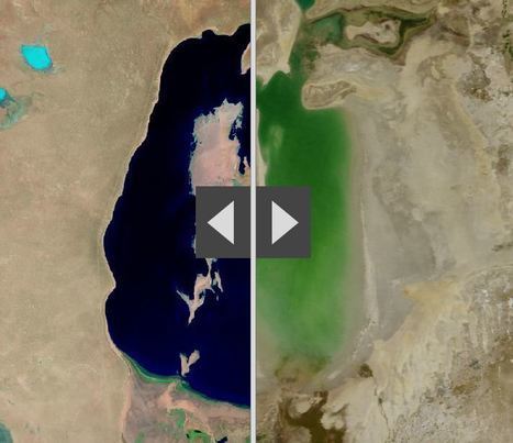
This map shows how human activities like farming has shaped the Earth's surface. The example they show is the Aral Sea. It is a
regional environmental problem. It is located between the Southern part of Kazakhstan and Northern Uzbekistan. It used to be the world's fourth largest saline lake. Human activities have caused the lake to be almost completely dried up. Over the years, the Aral Sea became polluted with pesticides and chemicals. 
Stevie-Rae Wood's curator insight,
October 28, 2018 9:51 PM
The Aral Sea is a severe environmental issue in Central Asia. This map that we are looking at shows how human activities such as farming have destroyed a natural wonder. The Aral Sea USED to be the fourth largest saline lake but has dried up. The Aral Sea has five times less volume and is five times more saltier than it once was. This occurred because people surrounding the area used more water and used it more intensely. The soviets thought it would be a good idea to use more water projects such as planting cotton, and rice which are water intense crops. This severely dried up the Sea. The area that the sea once was that is now dry land in uninhabitable because of the levels of salt left behind. As well the rivers that connected to the Aral Sea have either dried out or are on the verge of drying out causing many economic problems for those that depended on that water.
"How deep is that icy blue water on Greenland's ice sheet? Dr. Allen Pope, of the National Snow and Ice Data Center, is using data from the NASA/USGS Landsat 8 satellite to find out. In this video, Dr. Pope shares what he sees when he looks at a Landsat image of the Greenland ice sheet just south of the Jakobshavn Glacier. Tags: physical, geomorphology, landforms, erosion, climate change, Greenland, remote sensing, geospatial. Via Mike Busarello's Digital Storybooks

"Here’s a winning question for your next trivia night: Where is the world’s largest island-in-a-lake-on-an-island-in-a-lake-on-an-island? According to stories published here and here, the distinction currently goes to a nameless isle within Victoria Island in Canada’s Nunavut Territory. On August 21, 2014, the Operational Land Imager (OLI) on Landsat 8 captured this natural-color view of the “sub-sub-sub-island.” The top image shows a close-up view of the unnamed island, while the bottom image shows a wider view of Victoria Island’s lake-littered landscape (download large image here)."
Tags: Canada, trivia, remote sensing, geospatial. Via Mike Busarello's Digital Storybooks

"Lake Urmia in northwestern Iran was once one of the largest saltwater lakes in the Middle East, but it has diminished dramatically. Diversion of water from local rivers for agricultural use is one likely cause. Since 1996, drought has further contributed to the decline. The lake now covers about 10 percent of the area it covered in the 1970s. In the 2014 image, the entire southern portion of the salty lakebed is exposed. Also see this set of images." Tags: Iran, remote sensing, geospatial, unit 1 Geoprinciples, land use, food, food production, environment.

We've dammed mighty rivers, built hundreds of artificial islands, and made the world's fourth-largest lake disappear.

Courtney Barrowman's curator insight,
May 21, 2015 10:02 AM
Summer reading KQ2, How have humans altered Earth's environment? key concepts- remote sensing, land use

The new 550 megawatt facility in California produces enough electricity to power 180,000 homes. The modules are part of Topaz Solar Farm, one of the largest photovoltaic power plants in the world. At 9.5 square miles (25.6 square kilometers), the facility is about one-third the size of Manhattan island, or the equivalent of 4,600 football fields. Construction at Topaz began in 2011. The plant was mostly complete by November 2014, when it was turned on and began to generate electricity. Tags: energy, resources, unit 6 industry, California, images, remote sensing.

Maricarmen Husson's curator insight,
March 24, 2015 4:01 PM
GRANJA SOLAR TOPAZIO EN CALIFORNIA. PROVEE ELECTRICIDAD A 180.000 HOGARES. PLANTA DE ENERGÍA SOLAR

María del Sol Guerra martín's curator insight,
April 4, 2015 7:23 AM
In this text you will find information about a photovoltaic power plant. Could you find information about photovoltaic plants in Spain? 
Aleena Reyes's curator insight,
April 8, 2015 7:20 PM
Seeing America taking steps in use solar power makes me incredibly happy. The US, in my opinion, needs to adopt multiple ways of utlizing various types of energy sources. The quote, "BHE estimates, that is enough to displace about 407,000 metric tons of carbon dioxide per year, the equivalent of taking 77,000 cars off the road" is impressive. However, I do feel that the auto industry is the environmental scape goat. The textile industry produces much more waste, especially with all of the advancements the auto industry has gone through.

A school that lays in ruins, hospitals and refugee camps under attack, and a city center with the size of Manhattan destroyed by shelling — these are some of the shocking details of a new United Nations report on the conflict in Syria, four years after in began. Tags: Syria, MiddleEast, conflict, political, remote sensing.

Shane C Cook's curator insight,
May 27, 2015 8:57 AM
Due to the current terror war in Syria, it has caused many people to flee to surrounding countries or countries where there is no terror and discrimination. This has caused them to be refugees or internally displaced persons. 
Gene Gagne's curator insight,
November 4, 2015 4:42 PM
The stupidity of this whole thing is the reparations and its cost. Its the injury and death tolls during the conflicts followed by the high cost to rebuild. One must ask is the war or conflicts worth it.
Benjamin Jackson's curator insight,
December 13, 2015 7:20 PM
from the air the war looks like many historical photographs of bombings, and in this age of precision warfare it is somewhat disturbing that warfare can still look like this. this is a destruction of infrastructure on a scale unseen in the middle east since the Iran-Iraq war.

Canada is a massive country, yet it has one of the lowest population densities in the world. Despite this, Canadians have made a wide impact on their land, much of it visible from aerial and satellite photography. Hydroelectric facilities, roads, mines, farms, ports, resource exploration, logging, canals, cities, and towns have altered much of the landscape over the years.

Michael Amberg's curator insight,
May 26, 2015 11:28 PM
This shows how even small populations can make a big impact on the world from the changes in urbanization.

"Please join us in voting for DigitalGlobe’s fourth annual Top Image contest. From the trillions of pixels captured by our satellites this year, we need your help to decide which image showcases DigitalGlobe’s unique ability to solve important problems from space. Just follow these three easy steps:
"Watch along with Expedition 38 crew members Mike Hopkins and Rick Mastracchio as they look at various cities across the globe from the vantage point of the cupola on board the International Space Station." Tags: mapping, perspective, images, remote sensing, geospatial, unit 1 Geoprinciples.
|


Colleen Blankenship's curator insight,
January 4, 2017 3:41 PM
With a new president on our horizon, how will this affect our relationship with China?

From
www

"Two archaeologists, who recently published their findings in the American Schools of Oriental Research, used Google Earth satellite images and drone photography to identify the outline of an enormous monument buried beneath sand and time at the UNESCO World Heritage site in Jordan." --Motherboard

Zavier Lineberger's curator insight,
March 29, 2018 3:38 PM
(Middle East) Using modern technology, archaeologists have discovered a new monument hidden underground in Petra. The find, dated around 150 B.C., is thought to be a ceremonial site with two platforms, pottery. columns, and a staircase carved out of stone. It is amazing that there are still new finds like this in the 21st century, but the history of the Middle East is so incredibly old, with so many extinct civilizations, that archaeologists will probably keep making new breakthroughs.

brielle blais's curator insight,
April 1, 2018 4:40 PM
Physical geography can be really cool as understanding the current land helps to also understand the past. Researchers finding new monuments like this in Petra shows the importance of knowing the land around you, or someplace important like where the UNESCO World Heritage Site.
Benjamin Jackson's curator insight,
November 9, 2015 5:40 PM
The impact of the Three Gorges Dam on the residents upstream is amazing. I cannot imagine anything like this happening in the US, mostly because of the impact on the people both upstream and downstream. Ecological damage from this dam may not phase the Chinese government, but I think any North American or European government would shudder at the thought of the backlash among their citizens this would create. 
Matt Ramsdell's curator insight,
December 14, 2015 9:27 PM
Three Gorges damn in China is the largest dam ever constructed. This was created to save on power by creating hydroelectric power for the people of the land. One of the issues with this was the the flooding of the land up streams displacing millions of people. It created a larger up stream area and very small down stream. A lot of the people that lived up stream had to be relocated further inland and faced changing climatif weather. The banks of the river are carved out between what seems like mountainous regions so as you move more uphill the weather and temperature will be a whole new category of life (Depending on how far you relocated).
Stevie-Rae Wood's curator insight,
December 9, 2018 6:09 PM
From the animation that NASA has created of the construction of the Three Gorges Dam it is apparent that land has been lost. The Three Gorges Dam was created to generate more energy for Chinas growing economy. It is known as the largest hydroelectric project ever costing around 40 billion dollars and requiring 20,000 workers. There is a good and bad side to the creation of this dam. It has helped Chinas economy grow however to the expense of the people that were displaced because the dam took away land as we can see In the animation. It also effected people downstream negatively as we can see as well because there water supply was depleted. Like most things that take place today the people that benefit from something usually live far away from the problem while those that live closest pay the more costly price.

"A new census that shows that Earth is host to a staggering 3.02 trillion trees — more than scientists expected.The most recent estimate only counted 400 billion trees, reports Rachel Ehrenberg. Because prior studies used satellite technology alone instead of including data from on-the-ground tree density studies, writes Ehrenberg, they missed the mark. They also estimate that since human civilization began, 45.8 percent of all trees been lost."

Felipe Rengifo's curator insight,
September 16, 2015 10:49 AM
Censo de árboles está en 3.02 trillones de arboles
Suena como mucho, pero con en realidad son pocos para tanta gente.
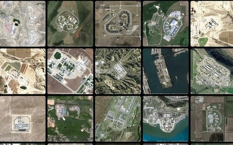
America has more than 5,000 prisons. This is what they look like on our landscape.
Begley’s images capture the massive scale of this entire industry and the land that we devote to it (America has less than 5 percent of the world’s population but houses a quarter of the world’s prisoners). His website, in fact, includes only about 14 percent of all of the prisons he’s captured (each one is scaled to the same size).
Tags: remote sensing, land use, geospatial, landscape. Via Dawn Haas Tache

Bob Beaven's curator insight,
January 29, 2015 2:27 PM
This article is interesting from a geographic and social perspective, because the overhead pictures show just how much we alter the land with our prisons. What is really interesting is how the US has less than five percent of the world's population but has one quarter of its prisoners. Because of this, it can be inferred that the country has many prisons. Yet, what astonished me about the prisons is that they seem to be out in the middle of nowhere. The buildings seem expansive on the landscape and dominate it. It just makes me wonder, how much does the United States spend on building and up-keeping these complexes. 
Incarceration's curator insight,
May 8, 2015 1:11 AM
This article explores a graphic representation of the quantity and volume of prisons throughout the United States. The project has no figures, statistics, or words - the pictures stand on their own as statements about the growing amount and size of prisons across the country. The photos show many rural prisons that house prisoners from urban areas, which changes both the areas where the prisons are and the areas that the inmates came from.
The photos are an intriguing visual of the money and materials put into prison systems in the United States. The photographer (Josh Begley) noted that upon seeing all the images together, the thing that stood out to him was that there were baseball fields in almost all of them. He says, "the baseball field mimicked the form about these buildings as well. There was something very American about it when I first saw it."
It's surprising to see how much material is necessary to, as the article described it, "warehouse" people. While prisons do more than just house inmates, seeing a visual representation of all the money put into prisons in the United States makes me wonder whether it could be better spent on reformed versions of prisons, rather than on maintaining the ones we already have and the new ones just like those that are currently being constructed.
- K 
Lydia Tsao's curator insight,
May 26, 2015 2:43 AM
These picture demonstrate the power of satellite imagery and technology perfectly. While I am amazed by the sheer beauty in spatial organization and design by these prisons, I am horrified at the maps incarcerations that are occurring in America, especially the mass incarceration of poverty stricken minorities in America. Prisons demonstrate a larger social issue than what I previously thought. I never knew that such a thing as prison-based gerrymandering could even exist. Prisons demonstrate economic and political problems as well. With more prisons, state must allocate more of their budget to supporting these facilities. The fact that so many prisons are being built demonstrate a larger problem in the political world, and that maybe there is an issue with the justice system. Fixing the system would allow for states to allocate more money that would have been use on supporting prisons to supporting education and helping those who are less privileged.

"Ross McNutt has a superpower — he can zoom in on everyday life, then rewind and fast-forward to solve crimes in a shutter-flash. But should he? Tags: governance, remote sensing, geospatial.

Ambre Cooper's curator insight,
June 25, 2015 4:04 PM
This is a cool little video. It even shows the level of Aral Sea we read about. 
Hamdou Wane's curator insight,
June 29, 2015 7:55 AM
Satellites have been watching us for 40 years. Here's what their images reveal 
Alex Smiga's curator insight,
August 6, 2017 8:45 AM
Seth Dixon's insight:
This video is simple entry point into the various applications of remote sensing as well as various human and environmental interactions. This video highlights 5 examples: 1. Deforestation (Brazil) 2. Water Use (Aral Sea) 3. Urban Sprawl (Las Vegas) 4. Energy (Coal in Wyoming) 5. Climate Change (Ice Shelf in Antarctica)
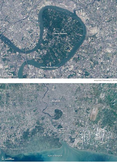
"In the heart of Thailand’s most populous city, an oasis stands out from the urban landscape like a great “green lung.” That’s the nickname given to Bang Kachao—a lush protected area that has escaped the dense development seen elsewhere in Bangkok. The city is built on the alluvial plain of the Chao Phraya River. Toward the southern end, near the Gulf of Thailand, is an old meander that never quite formed an oxbow lake. That meander traces the boundary of Bang Kachao, which TIME magazine once called the 'best urban oasis' in Asia. According to a travel story in The New York Times, Bang Kachao is gaining popularity among tourists lured by bike tours, a floating farmers’ market, and the relaxed atmosphere." Tags: physical, fluvial, remote sensing, land use, Thailand, Southeast Asia, urban ecology. Via GTANSW & ACT

Savannah Rains's curator insight,
May 27, 2015 1:51 AM
This scoop shows an example of built environmental space. The highly urban and crowded Thailand has little green space. So why is this massive green park looking landmass there? Its a strictly environmental section of land to help water flow into the ocean. The people call it the "green lung" because its plants give off oxygen and provide a contrast from its urban sprawl. This article shows the importance that should be placed on having more strictly environmental places in big cities. 
Chris Costa's curator insight,
November 9, 2015 2:06 PM
It's interesting to see the mixture of natural and manmade landscapes in this image. Humans have an enormous influence on the world around us- we have moved entire rivers for our own purposes, reshaped entire regions. In China, we have literally made it rain. Therefore, it's nice to see remnants of the rich environments that used to cover the urban sprawls of many of the world's largest cities, like Central Park in New York. Bang Kachao in Bangkok is another example of this, a reminder of the richness of the region before it was overwhelmed by the urban development that has characterized Bangkok over the previous century. The oasis serves as a valuable tourist attraction, as Westerners come to enjoy the bike trails and small farming community within Thailand's green lung. Leave it to hipsters to travel halfway across the globe just to enjoy nature within the confines of one of the world's largest cities.
brielle blais's curator insight,
May 3, 2018 3:55 PM
This showcases how important physical geography is. This "green lung" breaks up the high urbanized Bangkok. This helps the environment thrive and helps to cut down of emissions that affect climate change which is a problem in some areas.
A groundbreaking Mapbox project ushers in a new era for online cartography.
On Google Earth, the seasons rarely change. Most anywhere a digital traveler goes, the sky is cloudless and the grass is green. No snow on the ground in Iowa. No fire in Valparaiso. It's a big gap between the world as it is and as it's mapped. Launched Thursday,a landmark project from Mapbox has changed the summertime paradigm for online cartography. Landsat-live reveals the planet's surface in real time and in stunning resolution, fed by a constant stream of public-domain imagery from NASA’s Landsat 8 satellite. Via Mike Busarello's Digital Storybooks

Jacqueline Garcia pd1's curator insight,
March 22, 2015 12:47 PM
In this article we are shown the development and evolution of cartography. We can observe the changing geography on the planet and the real time gives us an accurate reading. I feel like this innovation could greatly help us. 
Seth Forman's curator insight,
March 23, 2015 4:34 PM
Summary: This interesting article talks a lot about modern technologies effect on the popularity of geography. This article talks about how programs like Google Earth have caused a general interest to arise about physical geography.
Insight: This article is significant to unit 1 because it shows how GIS can be so influential to not only geographers but to the rest of society.

Stunning images taken from space put the world's crises into context. U.N. satellite imagery has tracked the evolution of the camp since its creation. The exponential growth is remarkable. The refugee camp is rapidly taking the shape of a real city — structured, planned and even separated into neighborhoods and subject to gentrification. Tags: refugees, migration, conflict, political, war, squatter, urban, unit 7 cities, remote sensing, geospatial.

Norka McAlister's curator insight,
March 15, 2015 8:00 PM
I definitely think that it would. It is impressive to see how a urban planning affected the land designed by the refuges. Within a few years through satellite imaging, we can witness and appreciate how the Zaatarie refugee campus went from a few refugees to a total urbanized area receiving and distributed more than 85,000 refuges in the area. Urban planning plays a big role in regards to how display all populations. However, we have to take in consideration that when a massive population in one area is displayed, urban area is also relevant in terms of disciplines, public healthy, collaboration to live under a community rules. On other hand, natural disasters and destruction by war can wipe out entire cities within seconds. The satellite images were able to show the destruction that took place in the Syrian city of Hamas after natural diasters devastated the region and the wartorn afternmath of Gaza city. Natural disasters and war trigger a massive migration of refugees in search for better a life and opportunity. 
Max Minard's curator insight,
March 21, 2015 9:26 PM
This report refers to the Zaatari refugee camp in Jordan which is experiencing rapid growth in population with 85,000 citizens and is even starting to look as a "city built form scratch". The reason geographers think that satellite imagery can save refugee lives is because it allows them to view areas of the camp in which they are unable to reach on ground. This information will help health workers pinpoint these certain hidden areas and tend to the people who are there. This use of satellite imagery centers around the camps rapid growth in population, making it quite a challenge to scale on ground.

"60 years has made a big difference in the urban form of American cities. The most rapid change occurred during the mid-century urban renewal period that cleared large tracts of urban land for new highways, parking, and public facilities or housing projects. Fine-grained networks of streets and buildings on small lots were replaced with superblocks and megastructures. While the period did make way for impressive new projects in many cities, many of the scars are still unhealed. We put together these sliders to show how cities have changed over half a century. In this post, we look at Midwestern cities such as [pictured above] Cincinnati, Ohio."

Sierra_Mcswagger's curator insight,
March 10, 2015 10:22 AM
In the above picture of Cincinnati, Ohio it is clear how much change American cities have undergone in 60 years. In the process of urban renewal these cities have been affected tremendously with the addition of new roads, businesses, and most likely the turning of land over to private developers. All previous land has been renovated and changed into the typical urbanized American city. S.S.

What do you do when presented with a new satellite image? Here's what the Earth Observatory team does to understand the view. Via dilaycock
|


